Downloads
Overview
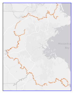
The Long Distance Trails line data layer represents trails that are longer than 25 miles. The data were created for the purpose of regional planning and mapping by the Massachusetts Department of Environmental Management (DEM), now the Department of Conservation and Recreation (DCR) and was modified for the DEM by the University of Massachusetts in 1997. DCR updated most of the trails with more accurate source data in June 2015.
This line feature class is named LONGDISTTRAILS_ARC.
Production
GPS data was obtained from various sources, e.g. DCR and trail organizations, where available, and merged to create this summary data layer. The Warner Trail is the only trail without GPS data; it was digitized from paper maps.
Attributes
The line attribute table contains the following fields:
| Field name | Description |
|---|---|
| NAME | Name of trail |
| NAME2 | Additional trail name information. |
| SOURCE | Source of trail data |
| GIS_MI | Length of each trail segment, calculated in miles. |
Maintenance
DCR is maintaining this data layer. An update in August 2015 restored the Midstate Trail to the layer.
Also see: