Background
In 2008, the Massachusetts Department of Fish and Game requested that MassDEP, the Division of Marine Fisheries, and the Department of Conservation and Recreation review reports completed by the United States Geological Survey (USGS) on the Lower Neponset River. The goal of the USGS studies was to provide environmental programs with information on the quality of water and sediments, so that informed decisions could be made regarding proposed river-restoration efforts.
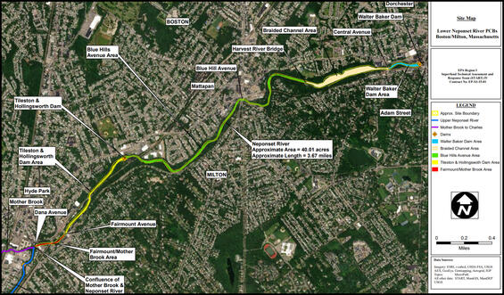
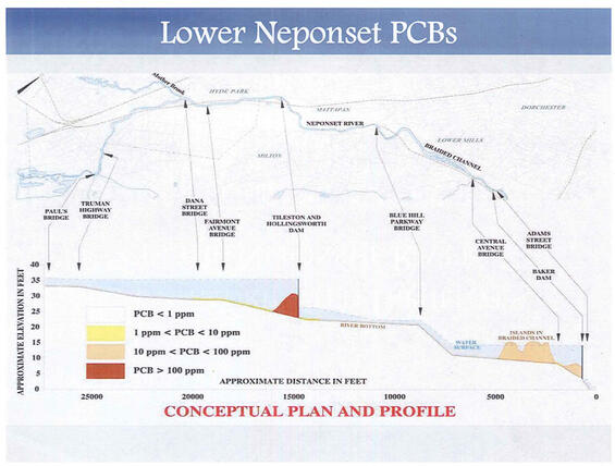
The USGS concluded that, “although enriched compared to background concentrations, sediment quality in the Lower Neponset River was generally better than that of other urban rivers in the United States, except with respect to PCBs.” The PCBs are bound to sediment particles and have settled out within the Neponset River behind the Tileston and Hollingsworth Dam (“T&H Dam”) and the Walter Baker Chocolate Dam (“WBC Dam”). Significant PCB contamination is also present in sediments in the mid-channel island area of the Lower Neponset River known as the Braided Channel. This area is located directly upstream of the WBC Dam in the vicinity of the former Jenkins Dam.
The PCB contamination is the result of industrial operations located along the river and its tributaries that date back to the 1930’s. The PCB contamination from these facilities is bound to sediment particles, which flowed downstream and ultimately settled out behind the dams.
Additional Resources
MassDEP Investigation – Neponset River/Mother Brook
MassDEP completed a review of PCB waste sites within the Neponset River Basin. A total of 34 sites were identified that had PCBs as a contaminant of concern, and were located in the vicinity of the Neponset River or one of its tributaries.
The largest volume and highest historical concentration of PCB contaminated sediment was located in the downstream section of Mother Brook, within ¼ mile of the confluence with the Neponset River. The concentrations of PCBs in the sediments of the Neponset River increase dramatically at the Mother Brook confluence, and the chemical signature of the PCBs in the Lower Neponset River is consistent with that of PCBs in Lower Mother Brook.
Mother Brook Remediation
From 2007 through 2011, the Thomas & Betts Corporation (having acquired the L.E. Mason Company in 1999) removed PCB-contaminated sediments from Mother Brook. The sediment removal operation at the Former L. E. Mason Site extended from the former facility to the confluence of the Neponset River, a length of approximately 1,400 feet. Sediment excavation was as deep as 34 feet below the riverbed adjacent to the former facility, and to a minimum depth of 3 feet below the riverbed along the remainder of the Brook.
Additional Resources
USEPA Actions
In November 2017 and September 2018 the USEPA completed two studies of the PCB concentrations of the sediments of the Lower Neponset River, in order to collect sufficient data to determine if this area would qualify for listing on the National Priorities List (NPL). The results of the USEPA studies confirmed the previous findings of the USGS and MassDEP; specifically, that a sediment plume containing significantly elevated concentrations of PCBs is present throughout the 3.7 mile riverbed segment of the Lower Neponset River from the confluence of Mother Brook with the Neponset River, downstream in the Neponset River to the WBC Dam.
EPA is currently preparing the documentation, called a Hazard Ranking System (HRS) package, to make a final determination regarding the Lower Neponset River’s eligibility for inclusion on the NPL. Following proposal to the NPL, a public comment period is held before a site is finalized to the NPL.
SUPERFUND- NATIONAL PRIORITIES LIST (NPL):
The (NPL) is a list of sites EPA determines require further detailed investigation and potential cleanup under the Comprehensive Environmental Response, Compensation and Liability Act (CERCLA), often referred to as Superfund.
- Sites on NPL subject of detailed investigation, and cleanup where warranted.
- Only sites on the NPL are eligible to receive federal Superfund resources for comprehensive cleanup.
- Federal resources can include monetary support, as well as expertise/staffing.
- Absent the use of federal resources, comprehensive cleanup strategies may not be able to be pursued.
Additional Resources
More Information
““The serious nature of contamination in the Lower Neponset River warrants its inclusion on the National Priorities List,” said former Governor Baker. “We look forward to continuing to work closely with our federal and local partners on the coordinated effort to clean up this site in order to protect the environment and public health.” ”