How will climate change make things worse?
Sea level rise resulting from the melting of arctic ice appears to be accelerating. Sea levels rose about 9 inches during the 20th century. By 2030, sea level is projected to rise by 0.6 to 1.1 feet above 2000 levels. By 2070, some projections estimate a rise in sea level of 2.3 to 4.2 feet over 2000 levels. Sea level rise combined with more intense hurricanes and winter storms present a serious threat to people residing in coastal areas of Massachusetts.
Who is exposed to sea level rise?
In coastal areas, rising sea levels may erode shorelines, threaten coastal drinking water supplies with salt-water intrusion, and displace residents. Sea level rise also contributes to higher storm surges and flooding during coastal storm events. “Tidal flooding” (very high tides not associated with storms) may damage beaches, roadways, and buildings. Flooding may expose individuals to physical hazards, contaminated flood water and drinking water, and may displace residents, leading to permanent relocation.
What are the health effects?
Storms and sudden inundation from rising seas pose a physical danger to those caught in their path. Health effects include increases in water-borne illness from contaminated drinking water supplies, complications of existing diseases, and increases in respiratory diseases due to mold from flooding. Property damage and displacement of homes and businesses can lead to loss of livelihood and long-term mental stress for those facing relocation or living in a deteriorating community. Some coastal communities may experience frequent road closures due to increased tidal flooding, impeding access to medical and emergency services. Individuals may also experience post-traumatic stress, anxiety, and depression following an extreme weather event and/or relocation.
Who is vulnerable to sea level rise?
Identifying populations most vulnerable to the health burdens of climate change is an important step in developing state and local adaptation plans. Publicly available data can be used to assess the health-related vulnerability for sea level rise. Some examples of vulnerability data for Massachusetts are provided below.
- An average of 21% of residential land in MA cities and towns is in a FEMA 100- or 500-year flood plain1
- 79 cities and towns in Massachusetts have MEMA coastal storm surge zones1
- In 2016, 10.3% of MA residents had active Asthma2
- 14.7% of MA residents are age 65 or older, and 29.2% of older adults live alone1
- 12.9% of coastal residents live below the poverty line3
How can we assess vulnerability to climate hazards?
Climate vulnerability is a function of:
- Potential impacts from exposure (contact with the climate hazard) and sensitivity (e.g., age, pre-existing health conditions, social disparities) that may increase or decrease health impacts
- Adaptive capacity – factors that influence the ability to respond and recover from climate impacts
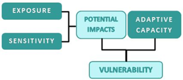
This page provides information to assess exposure, sensitivity, and adaptive capacity to reduce climate change impacts. This information should be considered when planning actions to reduce health risks from sea level rise in Massachusetts communities.
What are the factors that influence vulnerability to sea level rise?
Assessment of community-specific vulnerabilities will inform adaptation planning efforts. By considering these factors, communities can increase health equity and resilience to climate change impacts. The Massachusetts Environmental Public Health Tracking website provides helpful tools and community-specific vulnerability data.
- Sociodemographic
- People over age 65
- People over age 65 and living alone
- Children under age 5
- People of Color
- People who are living below the poverty line
- People experiencing homelessness
- People with limited knowledge of English
- Environmental
- Degraded water quality
- Coastal erosion
- Ecosystem damage
- Damage to aquatic and agricultural resources
- Loss of shoreline and recreational land
- Pre-Existing Health Conditions
- Adults with respiratory disease (e.g., asthma, COPD) and cardiovascular disease
- Children with respiratory disease (e.g., asthma)
- People using medical equipment that requires electrical power or medications that require refrigeration
- People with physical disabilities or special needs
- People with mental health challenges
- Infrastructure
- Interruption of utilities (e.g., electric, phone, internet)
- Failure of wastewater treatment systems
- Loss of safe drinking water
- Disruption of transportation and communication systems
- Loss of access to medical services
- Property damage and displacement of homes and businesses
Intervention Strategies for Reducing the Health Impacts of Sea Level Rise
- Identify vulnerable populations and health issues in your community using the DPH Community Profiles, and other tools available on the EPHT website
- Increase the use of climate and weather information in managing storm water/flood risk and individual events
- Identify and map vulnerable locations and populations using DPH’s Climate Change Vulnerability Mapping Tool
- Identify critical facilities and infrastructure at risk from flooding (e.g., water and sewer facilities susceptible to intrusion) and implement modifications that decrease potential flood damage and/or relocate critical infrastructure from vulnerable areas
- Assess capability to deploy power generators and water pumps to medical facilities
- Encourage preparedness in the home, schools, workplace, and healthcare facilities
- Develop communication and outreach plans to raise awareness of evacuation routes, flood zones, and response plans
- Support implementation of DPH’s Mass in Motion and other Wellness programs to increase community resilience
- Implement actions to prepare for storms from DPH’s Division of Environmental Health Regulations and Standards (EHRS)
- Implement actions to prepare for extreme weather from DPH’s Office of Preparedness and Emergency Management’s (OPEM) website
- Promote actions to address and prevent water damage and address mold growth following a storm or routine tidal flooding
- Incorporate information on sea level rise into coastal planning, transportation, and public works projects
- View the 2023 ResilientMass Plan for information on adaptation strategies
- View the Massachusetts Climate Change Adaptation Report, Chapter 6: “Human Health and Welfare” for health adaptation strategies
References
- Massachusetts Emergency Management Agency Surge Maps for Massachusetts Communities
- Massachusetts Department of Public Health Asthma Statistics
- 5-Year US Census American Cities Survey, 2018. For data, visit MassMapper.
Who can I contact to learn more?
Specialists at the Massachusetts Department of Public Health, Bureau of Climate and Environmental Health, are available to answer your questions. Contact us at 617-624-5757 (TTY: 617-624-5286).
Additional Resources
-
Open PDF file, 344.75 KB, Climate Hazard Assessment Profile: Sea Level Rise (English, PDF 344.75 KB)
-
Open DOCX file, 820.99 KB, Climate Hazard Assessment Profile: Sea Level Rise (English, DOCX 820.99 KB)