- Massachusetts Department of Environmental Protection
Media Contact
Edmund Coletta, MassDEP – Director of Public Affairs
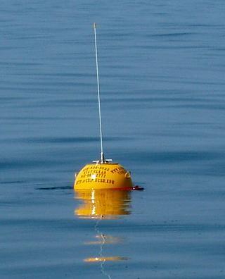
BOSTON — In an effort to expand marine safety in Buzzards Bay, the Massachusetts Department of Environmental Protection (MassDEP) has partnered with the Northeastern Regional Association of Coastal Ocean Observing Systems (NERACOOS) and the National Oceanic and Atmospheric Administration (NOAA) to support the long-term operation of a new high-tech wave-monitoring buoy. MassDEP will provide $905,988 in funding through the Oil Spill Prevention and Response Trust Fund for the costs associated with the purchase and installation of the new Buzzard Bay buoy, a replacement buoy in case of vessel collision, and five years of operation and maintenance of the Cape Cod PORTS marine safety monitoring system, which consists of the Cape Cod Bay buoy, Cape Cod Canal current-profiler, and the Buzzard Bay buoy.
“The waters of Buzzards Bay and Cape Cod Bay are precious natural resources in Massachusetts and we must continue to make strong efforts to protect them for both the public and marine species to benefit from,” said Energy and Environmental Affairs Secretary Kathleen Theoharides. “Adding this new buoy in Buzzards Bay will expand Cape Cod’s marine safety network and help ensure safe passage for mariners traveling through these important waters.”
“The Oil Spill Trust Fund has helped coastal communities protect their shorelines in the event of a spill; however, these wave-sensor buoys will aid in the prevention of spills and marine emergencies from even happening,” said MassDEP Commissioner Martin Suuberg. “With more than a billion gallons of petroleum products moving through Buzzards Bay and the Cape Cod Canal every year, this navigational aid will join a vital network that provides mariners with critical environmental and safety information.”
The buoy will be deployed by scientists from the Woods Hole Group approximately four nautical miles southwest of Cuttyhunk Island. Importantly, the buoy will improve safety and efficiency of marine transportation by providing sea-state information to mariners transiting the bay, in addition to expanding the online marine monitoring systems currently operating in the area.
Following the April 2003 grounding of the B-120 barge and subsequent oil spill into Buzzards Bay, the Oil Spill Prevention and Response Act established the trust fund to increase the Commonwealth’s ability to prevent and respond to marine oil spills. The Act allows the trust funds to be used for vessel navigational safety improvements, such as buoys and current-profilers.
“The data generated by the new buoy will help pilots determine best boarding arrangements to safely climb aboard ships bound for Massachusetts waters and give ship captains real time weather conditions,” said Captain Richard Astles, President of the North East Marine Pilots Association.
The buoy’s data will be integrated into NERACOOS’s buoy network map and added to the NOAA PORTS (Physical Oceanographic Real Time System) site for the Cape Cod area, which currently includes a buoy in Cape Cod Bay that was installed in 2016 and an ocean current-profiler at the west entrance of the Cape Cod Canal that was installed in 2019.
“Cape Cod PORTS is a model of effective collaboration in support of coastal communities and ocean-dependent industries,” said Jake Kritzer, PhD, Executive Director of NERACOOS. “We are excited to begin the next phase of partnership with MassDEP and NOAA to strategically deploy a portfolio of technologies to promote navigation and operational safety.”
“As maritime commerce continues to grow, real-time data provided by NOAA PORTS is increasingly vital for maritime safety,” said Richard Edwing, Director of NOAA’s Center for Operational Oceanographic Products and Services. “Integrating this new buoy into our Cape Cod PORTS will expand the information available to mariners, improving their ability to make timely, accurate, and informed navigational decisions.”
The buoy measures wave height, wave period, wave direction and surface water temperature every 30 minutes. The National Weather Service and the U.S. Coast Guard use these observations to help improve marine forecasts and to plan and conduct critical missions like search-and-rescue efforts. Data from the buoy will also help improve boater safety as users can verify current wave conditions before leaving the dock.
“The high-quality wave data generated by this buoy is a welcome addition to the weather data currently available to the many mariners utilizing Buzzards Bay,” said Captain Clint Prindle, Commander of the U.S. Coast Guard Sector Southeastern New England. “This additional information will help provide a clear picture of sea conditions to commercial mariners, the recreational boating community, and the many Coast Guard, state, and local vessels that conduct vital search-and-rescue efforts within this heavily trafficked area.”
Real-time observations from the buoy will be available on several websites, including www.neracoos.org, the Cape Cod PORTS page, and https://tidesandcurrents.noaa.gov/ and it will eventually be available on many boating and buoy websites and apps. Mariners are cautioned not to moor or tie their vessels to the buoys for any reason, as doing so may ruin the data transmitted by the buoy or damage the buoy or mooring. For more information on the Oil Spill Prevention and Response Act, turn here.
About NERACOOS: NERACOOS is the Northeastern component of the U.S. Integrated Ocean Observing System (IOOS®). The mission of NERACOOS is to produce, integrate and deliver high quality information that helps ensure safety, economic and environmental resilience, and sustainable use of the coastal ocean. NERACOOS and its partner organizations operate a system of data buoys, ocean sensors and ocean forecast systems that deliver real-time observations and predictions of ocean conditions available at www.neracoos.org
About NOAA: NOAA’s mission is to understand and predict changes in the Earth’s environment, from the depths of the ocean to the surface of the sun, and to conserve and manage our coastal and marine resources.
MassDEP’s mission is to protect and enhance the Commonwealth’s natural resources – air, water and land – to provide for the health, safety and welfare of all people, and a clean and safe environment for future generations. In carrying out this mission, MassDEP commits to address and advance environmental justice and equity for all people of the Commonwealth, provide meaningful, inclusive opportunities for people to participate in agency decisions that affect their lives, and ensure a diverse workforce that reflects the communities served by the agency.
###