Overview
The I-495 Andover-Lawrence Bridge Replacements Project includes six bridges on I-495. The structures are on I-495 where it follows the Andover-Lawrence border.
I-495 is a vital connector linking eastern Massachusetts to Cape Cod and southern New Hampshire. Private vehicles and heavy trucks delivering freight across the Commonwealth travel this interstate. Route 28 is a regional road that connects homes, businesses, medical care, and educational opportunities. Within the project area, on average, I-495 north and southbound each carry 57,000 vehicles each per day. Route 28, north and southbound each carry an average of 14,700 vehicles per day.
Beginning in the spring of 2024, MassDOT will fully replace all six bridges. This project allows MassDOT to provide the following improvements to all users:
- New bridges with fewer supports and expansion joints; meaning less impacts to roadway users from maintenance activities.
- Wider bridges that meet modern safety standards with more space on their decks will help to accommodate future maintenance activities.
- Safer acceleration and deceleration lanes for traffic entering and exiting I-495.
- Wider sidewalks and new bicycle lanes on Route 28.
Traffic and construction updates
Work anticipated for the week of June 28 through July 3
The project is now in its stage two traffic configuration. This includes a shift of all three lanes of I-495 northbound (towards Haverhill) into the median between Corbett Street in Andover and Route 114 in Lawrence and changes to exit ramp geometry at Ramp 99A (I-495 northbound to Route 28 southbound – towards Andover), Ramp 99B (I-495 northbound to Route 28 northbound – towards Lawrence) and the on-ramp from Route 28 northbound to I-495 northbound.
Motorists are reminded to reduce speed and pay close attention to all signage and the directions of police details and construction personnel while the traveling public acclimates to the new northbound configuration of I-495. A speed limit of 25 miles per hour is to be observed on all three of the ramps connecting to or from I-495 northbound within the project limits.
There will be no night work on Thursday, July 2nd or Friday, July 3rd in recognition of Independence Day.
I-495 Mainline
Activities
- There are no activities planned for the week addressed by this lookahead, but construction vehicles may be entering or exiting the median work zone to or from nearby ramps. Motorists are reminded that the mainline remains an active work zone and to reduce speed, exercise caution, and pay close attention to temporary signage and direction from police details while passing through the project area.
Surrounding interchanges
Activities
- There are no activities planned for the week addressed by this lookahead.
Route 28
Activities
- Demolition of the bridge carrying I-495 northbound (towards Haverhill) over Route 28 northbound (towards Lawrence).
- Clean-up of demolition debris and set-up work for nighttime demolition work.
- Excavation associated with the installation of soil stabilization devices for the new bridge which will carry I-495 northbound over Route 28 southbound (towards Andover).
Traffic Impacts by Time of Day
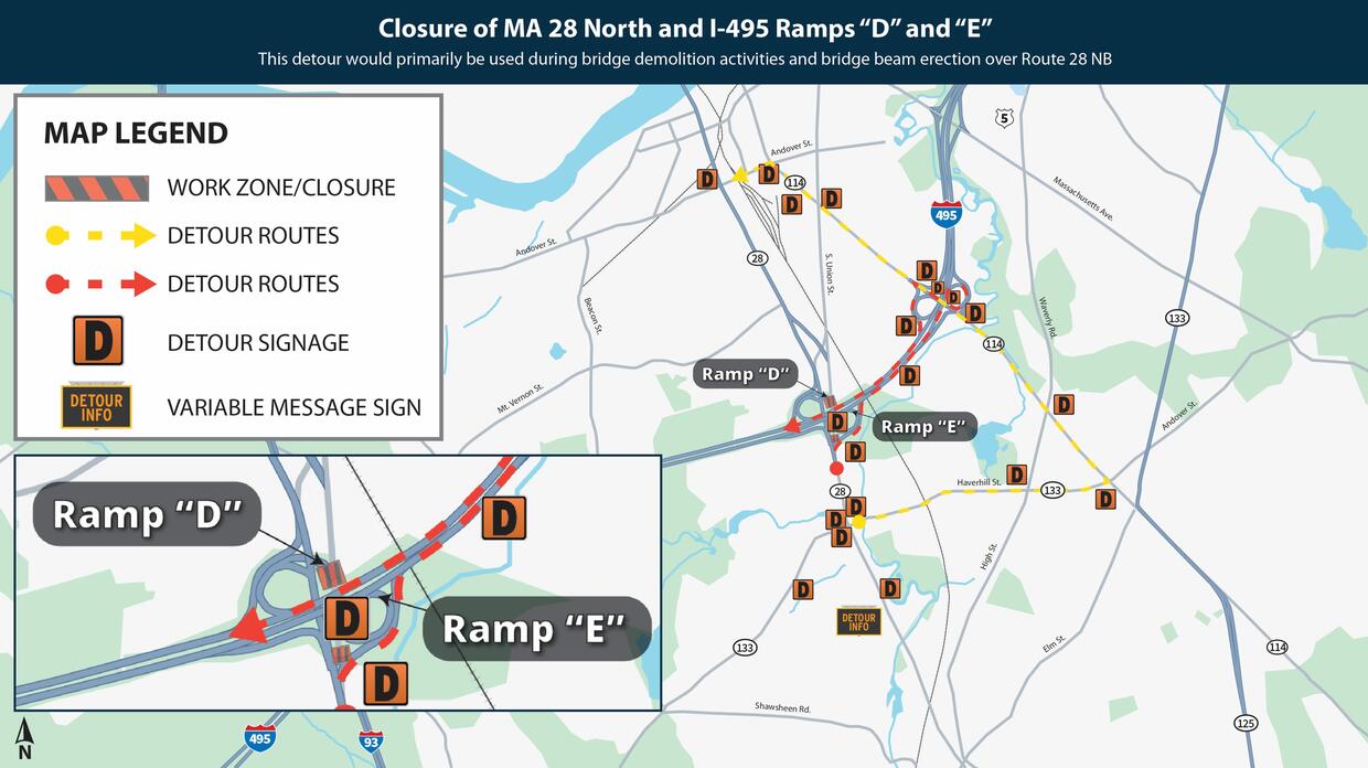
- For the demolition of the bridge carrying I-495 northbound over Route 28, full closure of Route 28 northbound where it passes below I-495, Ramp D (Route 28 northbound to I-495 southbound) and Ramp E (I-495 northbound to Route 28 northbound – towards Lawrence), beginning at 10:00 PM on Sunday June 28th with normal traffic conditions restored by 4:00 AM on Monday, June 29th. These closures will repeat during the same overnight hours, Monday, June 29th through Wednesday, July 1st. These closures will cause the following detours:
- Motorists seeking to travel south on I-495 from Route 28 northbound (ramp D) may:
- Enter I-495 northbound Haverhill Salisbury
- Remain in the right lane on I-495
- Take Exit 100 B 114 West S. Lawrence
- Prepare to merge left at the bottom of the ramp
- Use the signalized left lane to enter I-495 southbound Lowell Marlboro
- Motorists seeking to access Route 28 northbound from I-495 northbound (ramp E) may:
- Remain on I-495 northbound
- Take Exit 100 B 114 West S. Lawrence
- Take Route 114 north towards Lawrence
- Turn left off Route 114 (locally Winthrop Avenue) onto Andover Street
- Turn right off Andover Street onto Route 28
- Motorists seeking to continue north on Route 28 may:
- Turn right off Route 28 onto Haverhill Street
- Turn left off Haverhill Street onto Route 114 (locally Winthrop Avenue)
- Turn left off Route 114 onto Andover Street
- Turn right off Andover Street onto Route 28
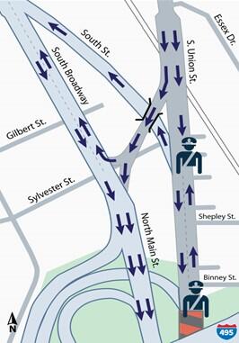
- During the closure of Route 28 under I-495, traffic that would normally travel along Route 28 southbound and then reverse direction to access destinations on Binney or Shepley Streets will not be able to do so. To maintain access to these residential areas, the section of Route 28 locally known as South Union Street will operate in a two-way condition under control of police details between 10:00 PM and 4:00 AM each night of the closure. One police detail will be stationed approximately just to the south of Binney Street, the other approximately where Route 28 splits into South Union Street and South Street.
- Motorists seeking to travel south on I-495 from Route 28 northbound (ramp D) may:
- For clean-up of demolition debris, set-up work for nighttime demolition work and excavation associated with the installation of soil stabilization devices, work will generally be behind barrier without impact to the traveling public, Monday to Friday, 7:00 AM to 3:00 PM for the period covered by this lookahead. Single vehicles may enter or leave the work zone to remove or deliver materials and personnel. Motorists are reminded that the area below the demolition zone on Route 28 remains an active work zone during daylight hours and to exercise caution while traversing it.
Noise impacts:
- Nighttime noise levels will be significantly elevated above normal traffic operations using hoe rams to demolish the bridge above Route 28 northbound during the overnight hours.
- Daytime noise levels will be roughly the same as normal traffic operations with trucks and excavators working in the area around the bridge being demolished.
Lay-down area
Activities
- Receipt of materials, equipment, and a point to gather for work crews and Massachusetts State Police details before entering the I-495 mainline.
Traffic Impacts by Time of Day
- Single vehicles entering and exiting the lay-down area under yield control from 7AM-3PM throughout the period covered by this look-ahead. This now includes Friday and Saturday.
- Multiple vehicles entering and exiting the lay-down area under State Police control during the overnight hours, between 7:00 PM and 5:00 AM depending on the exact date within the period covered by this look-ahead.
Noise Impacts
- None
MBTA Haverhill Commuter Rail Line
Activities
- There are no activities planned for the week addressed by this lookahead.
Completed work
- Shift from stage one to stage two traffic pattern: 95%.
- Demolition of the bridge carrying I-495 northbound over Route 28 southbound: complete.
Construction timeline
Construction will be staged to reduce impacts on abutters and commuters. The project is expected to run roughly four years and is broken into four, broad stages:
- Stage 1: Summer 2024 – Fall 2025
- Work in the median to create new roadway and bridge deck space.
- Construction of median crossovers.
- Stage 2: Fall 2025 – Fall 2026
- Northbound lanes of I-495 shifted into the median
- Work to rebuild bridges takes place in the vacated northbound lanes.
- Stage 3: Fall 2026 – Summer 2027
- Southbound lanes of I-495 shifted to the median
- Northbound lanes of I-495 shifted to the final alignment
- Work to rebuild bridges takes place in the vacated southbound lanes.
- Cycling and pedestrian improvements open on Route 28
- Stage 4: Summer 2027 – Fall 2027
- Traffic shifted to the final alignment in both north and Southbound directions.
- Improved acceleration/deceleration lanes in place.
- Median area vacated.
Project-associated detours and periodic lane closures
Some short-term, overnight detours are part of this project. These detours use main roads such as Haverhill Street (Route 133) and Turnpike Road (Route 114) to keep traffic off local streets and help maintain quality of life for area residents and access for area businesses. There will times when two-way traffic will run temporarily on normally one-way sections of Route 28 in the vicinity of Binney and Shepley streets. Homes and businesses on these streets will receive flyers in advance of the change of direction.
All detours and lane closures will be noticed using the project’s website and mass email system. The project will avoid lane closures and detours during peak commuting hours to help keep traffic flowing.
Committed to being good neighbors
The bridges over Route 28 and MBTA are closely surrounded by the community. Some homes in Andover are less than 400 feet from I-495. MassDOT is committed to minimizing, managing, and communicating construction impacts effectively while it completes this needed work.
To help the project be a better neighbor we will:
- Stage construction to provide a normal, simple configuration on I-495 with three lanes in each direction. During the design process, community members may have seen plans that split the lanes of one direction of the highway up with a work zone between them. By creating a work zone in the median of the highway first, we can create adequate space to build the new bridges and keep each direction of the highway as it normally is with three travel lanes together in each direction. This helps to prevent driver confusion and allows a smoother traffic flow.
- Provide real time traffic monitoring on I-495 to help keep regional traffic on the highway and off local streets.
- Avoid lane closures on Route 28 and I-495 during commuting peaks.
- Implement detours which rely on larger roadways such as I-495 itself, Route 133, and Route 114.
- Wet the old bridge’s supports during demolition to prevent dust from reaching nearby homes and businesses.
- Communicate real time traffic information changeable message signs. These signs are solar powered, making them quieter and better for the environment.
- Issue weekly email and web-based updates to keep all users informed about project progress, detours, and other roadway conditions. We will send emails to subscribed individuals, but also to partners who can help us get our message out ranging from local officials to local transit provider MEVA, area schools, social service organizations and more.
- Offer a project hotline in English, Spanish, and Vietnamese. MassDOT will activate the hotline in the spring of 2024.
Additional Resources
-
Open PDF file, 10.36 MB, MassDOT PIM presentation - Andover-Lawrence 4/24 meetings (English, PDF 10.36 MB)
-
Open PDF file, 322.49 KB, MassDOT PIM minutes - Andover-Lawrence 4/23/24 (English, PDF 322.49 KB)
-
Open PDF file, 335.59 KB, MassDOT PIM minutes - Andover-Lawrence 4/8/24 (English, PDF 335.59 KB)