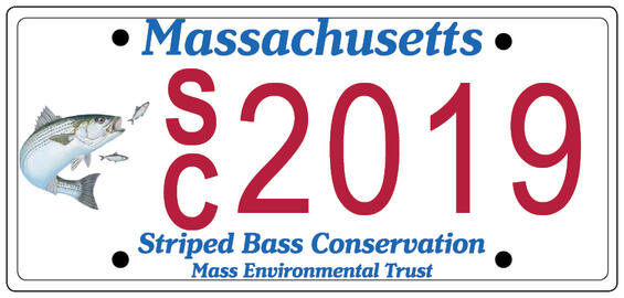
Striped Bass Conservation License Plate Coming
Massachusetts motorists will soon be able to display their passion for striped bass and river herring with a new specialty license plate issued by the Registry of Motor Vehicles. Created by the Massachusetts Environmental Trust (MET) and DMF, the new plate (once established) will support grants focused on:
- Studies of striped bass populations, stock structure, movements, and local ecology;
- Habitat improvements to enhance passage of diadromous fish (e.g., river herring, eels), thereby enhancing forage for striped bass;
- Studies of angler practices to improve hook-and-release survival; and
- Angler education to improve the conservation of marine fisheries resources.
This new plate, entitled “Striped Bass Conservation,” received strong support from former Energy and Environmental Affairs Secretary Matthew Beaton and the Trust’s Board of Trustees led by Chairman Bob Durand. The Trust commissioned Cape Cod artist Janet Biondi to create the custom image for the plate that depicts a striped bass in pursuit of alewives, one of its favorite forage species.
DMF and MET are now busy promoting the plate to fishing groups and the general public. The response has been excellent. To ensure adequate interest in a new plate, the Department of Transportation (DOT) requires us to receive at least 750 pre-orders before the plate will be printed. Applicants for the plate are filling out a standard form and writing checks for $40, which are being held by DMF until we reach the threshold when we will submit them all to the DOT.
Like all specialty plates, the cost to the motorist every two years is an additional $40 above the cost of a normal plate ($60). However, the disbursement of the funds for the striped bass plate will be unique because it will be overseen by a Review Panel including striped bass experts from DMF, academia, a conservation group, and recreational and commercial fishermen. Funds will not be used for any existing programs but instead will fund new studies and conservation initiatives. This model of oversight is similar to that which DMF receives from a citizen’s committee established by the Legislature to review our spending of recreational saltwater permit revenues.
This new plate will look great on any passenger vehicle and allow fishing advocates all over the state to make a strong statement to conserve marine fisheries resources.
By Dan McKiernan, Deputy Director
Additional Resources
White Shark Research Continues: Examining Feeding Habits and Study Area Expansion into Cape Cod Bay
As another summer is upon us, white sharks are returning to feed in Massachusetts waters. Since 2009, DMF biologists have been examining the movement ecology, behavior, natural history, and population dynamics of this species through its Shark Research Project. To date, agency staff have tagged more than 170 white sharks with a variety of high tech devices to study their fine- and broad-scale movements. Most of these sharks (93%) were tagged off Cape Cod, but others were tagged off New York, Florida, New Jersey, and South Carolina. The sharks ranged in total length from 4.0-17.5 ft and were comprised of juveniles, subadults, and adults of both sexes.
The agency has also been working with UMass Dartmouth’s School for Marine Science and Technology to examine the relative abundance and population size of white sharks off the coast of Massachusetts using spatial capture-recapture models. The objective of this project has been to estimate the abundance and relative density of white sharks off Cape Cod from photographic mark-recapture, aerial line survey, and acoustic telemetry data. To date, we have identified more than 350 individual white sharks over the last five years. The field component of this study was completed in 2018 and subsequent analyses are ongoing.
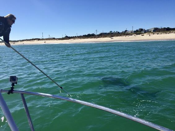
Building on its past work and in light of the growing presence of this species in our nearshore waters, DMF is intensifying its research to understand the predatory behavior of this species with particular emphasis on public safety. The aggregation of white sharks off the coast of Cape Cod is one of only a handful of hotspots in the world and unique along the east coast of the US. As such, Massachusetts and the towns on Cape Cod in particular are faced with a growing potential for negative interactions between this species and people utilizing our coastal waters. This potential has already been manifested in an increase in attacks on humans—the most recent causing fatal injury to a boogie boarder off Wellfleet in September 2018. Therefore, intensive research on the local movements and behavior of white sharks while in Cape Cod waters is warranted. Specifically, we need to know where, when, and how these sharks hunt seals, the frequency of feeding events, and environmental factors that drive the behavior of these animals. With adequate information related to these topics, we can develop, for the first time anywhere, predictive models that can be used to forecast the presence of this species so as to enhance public safety.
Fine-scale Behavior
Using a suite of tagging technologies, we are going to examine white shark residency, habitat selection, site fidelity, local offshore distribution, social interactions, and foraging behavior. The high-resolution data collected by these tags will be used to better understand fine-scale movements in areas of high shark/human overlap and will be used to identify factors correlated with both alongshore and onshore-offshore movements, which will better inform public safety practices. In doing so, we will be expanding our tagging efforts to include Cape Cod Bay, an area of increased white shark activity in recent years.
Coupled with these efforts, we will be developing a near real-time white shark forecast based on sightings, real-time detections from acoustic buoys, and the results of habitat models currently being developed. We envision the development of weekly forecast maps that could be disseminated to beach managers and posted at public beaches to alert beachgoers when conditions indicate a high likelihood of white shark presence.
In addition, data from these tags will be used to derive estimates of feeding frequency, which will provide a basis for assessing the intensity of white shark predation on gray seals. This is of certain interest to both commercial and recreational fishermen, as well as beach managers. Given our current assessment of the white shark population size, we will be able to estimate how many seals may be consumed by this species annually and the extent to which white sharks may potentially control seal population growth.
This research, when strengthened by strong collaborations such as the Atlantic White Shark Conservancy, will produce new, revelatory information about the white shark in the North Atlantic and, specifically, off the coast of Massachusetts. This information will not only provide the basis for sustainable conservation and management of this species, but also produce viable information for science-based decision making as it relates to public safety.
By Greg Skomal, PhD, Recreational and Diadromous Fisheries Program Leader
Helping Recreational Anglers Catch Haddock…and Avoid Cod
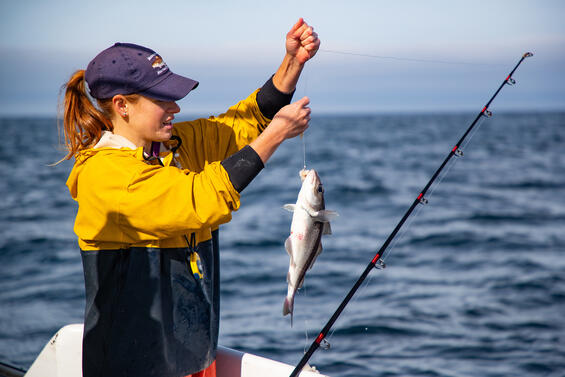
The current record-high biomass of the haddock stock has created outstanding recreational fishing opportunities for Massachusetts anglers in recent years. Unfortunately, the same cannot be said for the cod stock, which remains at a very low level. Even though the possession limit for cod has been set at zero for the past couple of years, cod are still caught as bycatch by recreational anglers targeting haddock, and a fraction of these fish die after they are released. DMF found in a previous study (conducted in partnership with the New England Aquarium, the University of New England, and the University of Massachusetts Dartmouth) that approximately 15% of cod bycatch dies after being released, resulting in the largest estimated source of mortality for cod in the Gulf of Maine currently. For this reason, there continues to be limits on the recreational haddock fishery, even though that stock is abundant and far from overfished. Looking at recent recreational survey data, it’s clear that charter and party vessel captains have been able to find areas to take anglers haddock fishing where there is less cod bycatch. However, it appears that recreational anglers fishing for haddock from their own boats haven’t had the same success in avoiding cod.
To counteract this issue, DMF is again teaming up with the New England Aquarium to develop a series of recreational fishing maps that will guide anglers on where to find good haddock fishing while avoiding high cod bycatch. The maps are informed by DMF’s Industry-Based Survey, which used bottom trawls to intensively sample the groundfish populations in the western Gulf of Maine over the past three years. By comparing the catch rates of cod and haddock to environmental variables such as depth, temperature, and habitat, we have created a spatial model that predicts the recreational catch of both species. This summer (May through September), we are testing the model predictions through standardized fishing aboard 40 charter trips. Once the guidance maps have been validated, we will publish full-color, waterproof map booklets to be freely distributed at tackle shops, permit offices, and sportsman’s shows. The maps will also be available for download to be used with a location-aware smartphone app. Through this effort, we hope to assist recreational anglers in finding some great haddock fishing while avoiding cod, and prevent the need for further restrictions on this abundant resource.
By Micah Dean, Marine Fisheries Biologist
Fluke Quota on the Rise
After bottoming out in 2017, the Commonwealth’s commercial fluke quota is on the rise. The cause is two-fold. Starting this year and continuing through 2021, the coastwide catch limits were increased significantly based on a new assessment showing a healthier stock than previously estimated. Beginning in 2020 or more likely 2021, changes to the manner in which the commercial quota is allocated amongst the Atlantic coastal states are also expected to take effect.
Last fall, fluke and striped bass were the first two species to be re-assessed using a newly revised time series of recreational catch estimates as produced by the Marine Recreational Information Program (see DMF News Volume 42 for details on how the survey methodology was changed). For fluke, these new estimates increased the total annual catch (1982–2017) by an average of 29%, the major effect of which was to scale up the assessment model’s estimates of spawning stock biomass, or “SSB.” Whereas the last stock assessment’s estimate of SSB in 2015 was just 16% above the overfished threshold, the new assessment estimated SSB in 2017 to be 56% above its threshold (and 78% of its target level). It is notable however that SSB has generally declined since the early 2000s, most appreciably from 2012 onward due to poor juvenile recruitment into the population in recent years.
Fishing mortality estimates were not largely affected by the new recreational data, but the threshold level for overfishing was increased by the changed biomass estimates. As a consequence, the stock is no longer considered to be experiencing overfishing (as it was after the last assessment), rather the stock is considered to have been fished at a sustainable level since 2001. Another outcome, and one of interest to discussions about quota reallocation, was a continued northward and eastward shift in the species’ spatial distribution.
The Atlantic States Marine Fisheries Commission and Mid-Atlantic Fishery Management Council reviewed these results in March and set three-year specifications of catch limits based on projections from the stock assessment. The trend of below average recruitment in recent years was factored into how these projections were developed, building in a bit of a safety net. To provide for more stability in the fishery, the management bodies set the commercial quota and recreational harvest limit at constant levels for 2019–2021. The resulting commercial quota of 11.53 million pounds is a 74% increase from 2018. However, the actual 2019 coastwide quota was reduced to 10.98 million pounds to account for a catch limit overage in 2017.
After applying our current 6.82% share of the coastwide quota and accounting for a Massachusetts quota overage in 2018, the Commonwealth’s fluke quota for 2019 is 741,532 pounds. That’s an increase of 83% from our overage-adjusted 2018 quota of 404,742 pounds. DMF did not amend Massachusetts’ commercial fluke rules for 2019, in part due to timing but also with an interest to let the directed summertime fishery regain the season length it had lost under the prior years’ restricted quota levels. We can make in-season adjustments to the trip limits and open days to fully-utilize the quota if necessary. DMF will be proposing to increase the landing limit for the offshore fishery that operates February to late April for 2020, due to the 2019 fishery utilizing well below its 30% target allocation of the state’s quota. Changes to the inshore directed fishery that begins in late June could also be considered for 2020 depending on how the 2019 fishery performs.
Barring any state or coastal overages, Massachusetts quota will increase a little in 2020 (i.e., to 6.82% of 11.53 million pounds). This assumes that NOAA Fisheries does not implement the quota reallocation strategy selected by the Council and Commission in March until January 1, 2021, which the agency has said is a more likely timeline than in time for the 2020 fishery. For several years, the so-called Commercial Issues Amendment has been under development, with quota reallocation being the most contentious item.
As with many reallocation discussions, this one sought to balance preserving historic access and the infrastructure built up around it with providing additional access where it is needed. In this case, the shift in the species distribution to the north and east, as documented again in the latest assessment, was at the heart of the matter, causing a largely north vs. south split in the opinions on if and how to reallocate the quota. The existing allocation formula is based on the states’ landings during 1980–1989, and has not been updated in response to how the species, and the vessels that pursue them, have redistributed.
The revised approach to quota reallocation maintains the current shares for quota up to 9.55 million pounds. Quota above this 9.55-million pound trigger will be allocated in equal shares of 12.375% to all states except ME, NH, and DE which share a 1% allocation. The New England states heartily opposed the trigger approach as an inappropriate response to the species’ shift in distribution, both in terms of its equal shares to states regardless of regional resource access and its singular implementation despite a likely continuum of shifting resource distribution.
Nonetheless, Massachusetts will see an increase in quota from what it otherwise would have been—so long as the quota remains above 9.55 million pounds. This is because the 12.375% share is greater than MA’s existing 6.82% share. The same cannot be said for a state like Rhode Island, which despite seeing increased availability of fluke like MA, will lose access when the quota is above the trigger because its existing allocation is 15.68%.
At an 11.53 million pound coastwide quota, the 9.55-million pound trigger approach reallocates 1.98 million pounds of quota per the new formula, providing Massachusetts with 896,113 pounds. This amounts to 7.77% of the coastwide quota. (Note that this de facto share is not static but changes depending on the quota level above 9.55 million pounds.) This quota can be compared to 786,253 pounds without a change from the current allocations, amounting to a 14% benefit to our fishery from the trigger-based approach at a quota level of 11.53 million pounds.
The Council and Commission have now initiated similar discussions about commercial quota reallocation for black sea bass. This is a species that is surging in southern New England waters to the point of becoming a nuisance in some instances of targeting other fish. A trigger-based approach would appear the likely outcome again, given the New England states’ disadvantage in voting for Mid-Atlantic Council managed species. But, we also learned a few things from the experience with fluke that may be useful in attempting to achieve an alternative outcome that more accurately pairs the problem with a solution.
By Nichola Meserve, Fisheries Policy Analyst
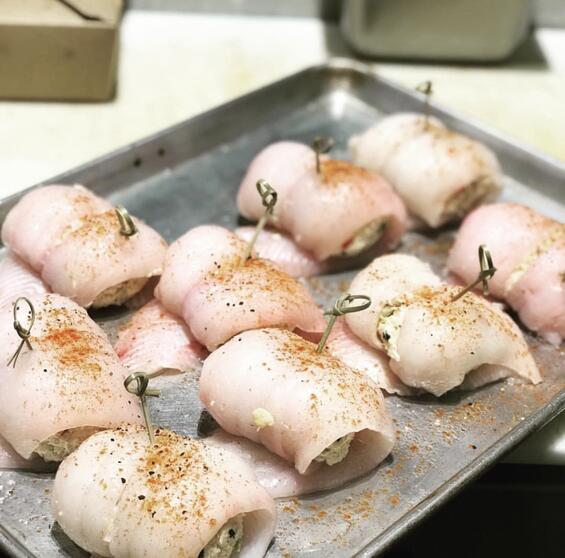
The Dish on Fish: Fluke Florentine
Summer flounder, also known as fluke, is a flatfish available in our nearshore waters from late spring into the fall. It is also landed here February–April from offshore waters. This fish is one of the most popular commercial and recreational fish along the Atlantic coast. It’s a delicate flavor white meat, with a flaky and fine texture. Local wild-caught fluke is a sustainable seafood choice, as it is responsibly managed and harvested under federal, interstate, and state regulations.
Ingredients:
- 5 tablespoons butter (divided)
- 1/4 cup onion (minced)
- 1 pound fresh or frozen spinach (chopped, cooked, cooled, and squeezed dry)
- 1/2 teaspoon oregano
- 2 pounds flounder fillets
- 1/2 cup white wine (dry)
- 3 tablespoons flour
- 1/2 teaspoon dry mustard
- 1 cup milk
- 1/4 cup parmesan cheese
Directions:
Melt 2 tablespoons butter in skillet, and saute onion until translucent. Stir in spinach, oregano, and salt and pepper to taste. Put about 1 1/2 tablespoons spinach mixture on each flounder fillet; roll up. Put the fish rolls in baking dish, seam side down. Add wine. Cover and bake 25 minutes at 350 F. Drain and reserve 1/2 cup of the liquid. Melt remaining 3 tablespoons of butter in a saucepan over medium-low heat; add flour, salt, pepper, and mustard. Add reserved liquid and milk and stir until thick and bubbly. Pour over stuffed flounder rolls. Sprinkle with parmesan and paprika just before serving.
Enhanced Protection for Spawning Sea Herring
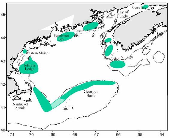
Sea herring, the important forage and bait fish that caught the region’s attention after a 2018 stock assessment indicated a sharp decline in the population, has received additional protections focused on spawning. The lack of a recent strong year class and historically low recruitment over the last five years prompted the Atlantic States Marine Fisheries Commission (ASMFC) to enhance protections for spawning herring in the Gulf of Maine and collaborate with the New England Fishery Management Council (NEFMC) to develop protections for Georges Bank.
Atlantic herring spawn in the northern portion of their range, from Cape Cod to Newfoundland. Within this northern region, there are three known spawning areas—coastal Gulf of Maine, offshore Georges Bank, and Nantucket Shoals—each of which consists of smaller, discrete spawning sites (e.g., Jeffreys Ledge in the western Gulf of Maine). During spawning, herring deposit eggs that stick to pebbles and cobbles on the seafloor, typically in depths of 50–150 feet. A single female herring can produce up to 200,000 eggs. Schools of spawning herring can produce dense mats of eggs that cover the ocean bottom. Eggs hatch 10–12 days after spawning and the pelagic larvae can be found throughout the Gulf of Maine, Georges Bank, and southern New England.
Gulf of Maine Spawning Protections
Herring spawn in the late summer and fall, typically starting in the more northern regions of the eastern Gulf of Maine in August and continuing south in waters off New Hampshire and Massachusetts through October and November. However, the start and length of the spawning season is variable from year to year, and commercial fishing in Herring Management Area 1A overlaps with spawning times and locations. To protect the spawning fish, there are three closure areas within the Gulf of Maine that prohibit directed herring fishing during the spawning season. The timing of the closures is based on a protocol developed in 2016 that uses a measurement of fish reproductive status calculated from herring samples from each area. Models are then used to forecast the date when herring in each area will be in spawning condition and the areas will close.
In response to documented low herring recruitment over the last several years, ASMFC assessed the spawning closure protocols and made improvements to further protect spawning herring. Previous regulations closed the spawning areas for four weeks when the forecast model predicted that ~25% of herring in the region were in spawning condition. The areas could be reclosed for an additional two weeks if samples showed significant numbers of spawning herring remained in the region. The new regulations, called Addendum II to Amendment 3 of the Atlantic Herring Fishery Management Plan, lower the threshold for closure to 20% of herring in spawning condition, extend the closure to 6 weeks, and reclose the area if 20% or more herring have not yet spawned. In addition to allowing more herring time to spawn without disturbance from the fishery, these measures may also reduce uncertainty in managing the fishery since it will be less likely that a reclosure will be needed. The new protocols were voted into place in April and will be effective to protect spawning herring in the Gulf of Maine this year.
Georges Bank and Nantucket Sound Spawning Research
The importance of the Georges Bank and Nantucket Shoals spawning grounds is well known, but details about offshore herring spawning are less understood than the inshore component. It is generally agreed that offshore spawning occurs around the same time as inshore spawning, but the precise timing and locations are not known. The overall offshore spawning area is quite expansive, and determining the spatial extent of discrete spawning grounds would require extensive sampling efforts prior to and during the spawning season. Additionally, the potential economic impacts of a fishery closure on Georges Bank would need to be considered. A further challenge is that the relationship between fish size and maturity may be different for the offshore spawners. Research is needed to inform the models that forecast spawning time based on reproductive status. These challenges require new research and funding to determine how best to enact offshore spawning protections.
ASMFC and NEFMC recently committed to addressing some of the challenges associated with trying to protect the offshore spawning grounds, and research to improve general understanding of the offshore herring resource is underway. In October 2018, ASMFC’s Herring Board initiated Addendum III to consider the establishment of a spawning protection program for Herring Management Area 3 (Georges Bank and the backside of Cape Cod). Additionally, the ASMFC Executive Committee committed funds to collect samples of offshore spawning herring in 2019 to identify discrete spawning locations and timing.
Following suit, the NEFMC solicited for an independent contractor to develop a Discussion Document on offshore spawning. The Gulf of Maine Research Institute was awarded the contract, which began in May. The purpose of the document is to support ASMFC and NEFMC deliberations about potential management measures that may be considered to minimize impacts on offshore spawning herring. Specifically, the Discussion Document will include a review of historical and current research on herring spawning, maps showing historical and current spawning locations and egg beds, and all available information about location, season, condition, and trends in spawning activity. The document will be completed in late summer for NEFMC deliberation in September 2019, and the joint efforts of the ASMFC and NEFSC may result in management actions as soon as 2020.
By Cate O’Keefe, PhD, Marine Science and Policy Analyst
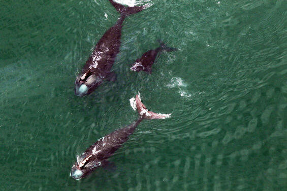
Right Whales Continue to Visit Cape Cod Bay in Large Numbers
Cape Cod Bay continues to be a vital habitat for the imperiled North Atlantic right whale, which has struggled in recent years with a declining population trend, high mortality, low birth rates, and changes in their food supply. In 2019, approximately 65% of the known right whale population was documented in the bay, including four of the mere seven calves born in 2019.
The bay appears to be an increasingly important seasonal feeding habitat for right whales. Zooplankton resources in this area have not been as sensitive to temperature-related changes, unlike habitats in the eastern Gulf of Maine which have seen significant declines in zooplankton. Right whales have largely abandoned those habitats as a result. While the right whale’s preferred food of Calanus copepods didn’t show up in their typical huge numbers in Cape Cod Bay in 2019, a variety of other zooplankton species were also present for them to forage on.
Aerial surveys found a season-high of 129 individuals at the beginning of April, after which the numbers slowly dwindled. Some animals stuck around into the first week of May, including mother/calf pairs. With such a large portion of the right whale population aggregating in Cape Cod Bay, it is critical to protect them from entanglement and vessel collision while in our waters. DMF achieves this through a seasonal fixed gear closure and speed restriction on small vessels (complementing a federal restriction on large vessels) in Cape Cod Bay and surrounding areas. Both of these measures can be extended beyond their April 30 termination due to continued right whale presence, which was the case in 2019, resulting in about another week’s worth of these measures being in place.
As the season for right whales in Cape Cod Bay was winding down, the Atlantic Large Whale Take Reduction Team met in Providence to discuss ways to further protect the whales from entanglement in fishing gear. The Team expressed broad support for reducing the number of endlines in the water and for reducing the breaking strength of those endlines to around 1,700 pounds. New England states will be conducting industry scoping meetings this summer to discuss potential ways to accomplish this goal.
Another interesting feature of the 2019 season took place outside of Cape Cod Bay. The National Marine Fisheries Service documented aggregations of right whales south of Nantucket and Martha’s Vineyard from November through May. It’s unclear at this time if this is a new trend or something previously undiscovered.
DMF collaborates with the Center for Coastal Studies and the National Marine Fisheries Service on the aerial surveillance program that collects information on the demographics, distribution, and abundance of the right whales that visit our waters. The timely and accurate reports and forecasts of whale distribution and abundance that the survey provides allow DMF to responsibly manage the area. A combination of federal funds from National Marine Fisheries Service and state funds from the Massachusetts Environmental Trust support the survey program’s continued success.
By Erin Burke, Protected Species Specialist
River Herring Counts on the Rise for Four MA Rivers
DMF is heavily invested in monitoring, restoring, and managing populations of sea-run fish. These are the fish that feed many species of wildlife including stocks of commercially and recreationally important marine resources. The iconic river herring is the most abundant and best known diadromous fish. Our staff cycles through the seasons to monitor and restore spring spawning runs, juvenile emigration, and habitats, and to construct fishways during low-flow.
With over 100 river herring runs in coastal Massachusetts, there is something to cheer about each spring. While not all run count data have been fully processed yet, 2019 stands out for producing several larger herring runs with the highest spawning run counts seen in many years. Though numerous small runs continue to post spawning counts near historical lows, at least four rivers will exceed a half million fish in the spawning run: the Mystic River in Medford, the Nemasket River in Middleborough and Lakeville, the Monument River in Bourne, and the Herring River in Harwich. This year is projected to have the highest count for the Monument River in 19 years. The Herring River is the first run with a count of over 1 million fish in 17 years (since the Nemasket River in 2002), and it’s only the second time that threshold has been exceeded in over 30 years of spawning run counts in Massachusetts. At no point in this period have more than two monitored runs exceeded a half million fish.
Runs elsewhere in Herring Brook, Pembroke and in Town Brook, Plymouth are also surging this spring after years of steady restoration activity. The Pembroke run will fall just short of a half million fish and Town Brook should post the highest count in its data series. All these spawning adults mean many more millions of juvenile herring to feed the masses.
A common theme with most of these larger runs has been dedicated local stewardship and close coordination between the DMF Fishway Crew and project partners to identify passage improvements needed along the migratory route and chip away at these tasks. Here are two recent projects that are helping to bring more fish to the Commonwealth’s rivers.
Pilgrim Lake, Orleans. The Fishway Crew teamed up with the Town of Orleans last fall to reconstruct the outlet fishway at Pilgrim Lake. The existing fishway was originally built in 1935 and its replacement had been a high regional priority for a decade. This activity follows seven years of cooperative work with Orleans to address several antiquated features downstream of the outlet. We upgraded the weir and pool fishway design from a two-weir to a seven-weir to improve passage and maintenance efficiency. The town’s Harbormaster and Water and Public Work departments lent their equipment, labor, and local knowledge to the project. It is an excellent example of the efficient and inexpensive partnerships that DMF forms with towns to keep the passageways open for these spring migrants. The site included a new electronic fish counter that documented about 15,000 spawning adults in 2019. When restoration began at Pilgrim Lake in 2011 the spawning run was posting counts of just a few thousand fish. Since 2017, the run has increased to 15–30 thousand fish.
Forge Pond Dam, Kingston. After years of discussions, this winter DMF signed an agreement with the City of Brockton to provide fish passage at their Forge Pond Dam in the Jones River watershed. The Fishway Crew fabricated and installed a custom wood fish ladder at the dam on April 22. Soon after, river herring and other fish species were observed using the fish ladder to enter Forge Pond and migrate further to the 640-acre Silver Lake. This marks the first time in well over 100 years that river herring could complete this native pathway to spawning and nursery habitat. It also comes in the wake of years of downstream restoration activities and support from the Town of Kingston, project partners, and local advocates. Other sea-run fish, such as white perch, lamprey, and American eel have been seen below the dam and are expected to move into Silver Lake. Our work is not done here. More coordination is needed with the City of Brockton to develop fishway operations compatible with their water supply operations and to design and permit long-term fish passage facilities at Forge Pond Dam.
By Brad Chase, Diadromous Fisheries Project Leader
Horseshoe Crab Stock Status in the Northeast Improves
Once considered a nuisance species for preying on shellfish, Atlantic horseshoe crabs are now the subject of a valuable fishery, with a Fishery Management Plan designed to conserve and protect their populations. A recently completed stock assessment will be the subject of upcoming interstate management discussions as to whether that FMP requires further revision. Massachusetts is unlikely to face any new requirements given a favorable trend in our regional stock status for horseshoe crabs.
Found from Maine to the Yucatan Peninsula in Mexico, horseshoe crabs are most abundant in the Delaware Bay region where their eggs provide an important food source for migratory shorebirds. They are harvested to provide bait for the whelk and eel fisheries as well as blood for the biomedical industry which uses it to make Limulus amebocyte lysate (LAL), a test for bacteria on products that are injected or implanted into the human body (e.g. insulin, pacemakers, knee replacements, vaccines).
The horseshoe crab population is assessed and managed by the Atlantic States Marine Fisheries Commission (ASMFC), which finalized the 2019 Benchmark Stock Assessment this past May. The stock assessment divides the horseshoe crab population into four regions and uses data from fisheries-dependent sources (including landings) as well as from scientific surveys to characterize stock condition. Regional stock status (“poor,” “neutral” or “good”) was determined based on the percentage of surveys within a region that had fewer crabs in 2017 (the most recent year of data included in the assessment) than 1998 (the year horseshoe crab management was enacted).
For the northeast region, DMF’s Fall Trawl Survey (south of Cape Cod) and the Rhode Island Monthly Trawl Survey (fall months only) were used to assess stock status. These two surveys showed conflicting trends, with the Rhode Island index decreasing in recent years while the DMF index has been increasing. Stock status for the northeast region was determined to be “neutral,” which is an improvement from previous assessments (2009 and 2013) when horseshoe crab status was characterized as “poor.” This improvement in stock status is largely due to a recent increase in the number of crabs in Massachusetts.
The increase in horseshoe crab abundance observed in Massachusetts could be due to many factors, including changes in conservation strategies. In the mid-2000s, DMF responded to the very low numbers of crabs found in the trawl survey by introducing a number of regulatory changes. These regulations included a moratorium on issuing new harvest permits, a reduction in the daily harvest limits, a minimum legal size, and the prohibition of harvesting crabs for bait in Pleasant Bay. DMF also instituted five-day harvest closures around spring new and full moons, specifically to protect spawning crabs and enhance reproductive success during this time period of peak spawning activity. In addition to these state regulations, the federal government closed areas around Monomoy Island and the Cape Cod National Sea Shore to the harvest of horseshoe crabs.These regulations may be partially responsible for the increase in the number of crabs seen in Massachusetts.
Additional items of interest from the 2019 assessment include the assessment team’s examination of mortality rates associated with biomedical and commercial discards. Crabs harvested to produce LAL are generally returned to the water after they are bled.The assessment team conducted a thorough review of the literature regarding mortality in crabs bled for the biomedical industry, and concluded that the previously used discard mortality rate of 15% is scientifically sound. The team also reviewed data on commercial discards for the Delaware Bay region, and concluded that horseshoe crabs caught and discarded in commercial fisheries from that region could be an important source of mortality and additional work should be conducted to better understand this issue.
The full stock assessment and peer review report can be found on ASMFC’s website.
By Derek Perry, Invertebrate Fisheries Biologist
Additional Resources
Seafood Marketing Grant Program Update
DMF announced $116,034 in funding for three research projects that will provide insight on the Commonwealth’s seafood sector through the Seafood Marketing Grant Program, a program in its third year that was created to enhance the viability and stabilize the economic environment for our local commercial fishing and seafood industries and communities. The research reports generated by the grant recipients will be spread statewide and beyond to inform the work of organizations, advocates, municipalities, and others about our port infrastructure, consumer preference of local seafood, and fishermen’s approach to traceability technology. The stakeholder engagement, literature reviews, and surveys done by the awardees will advance the efforts of those with similar goals as DMF. The following applicants received grants:
$25,000 - Fishing Partnership Support Services: Involving MA Fishermen in Seafood Traceability Programs
The Fishing Partnership will research current seafood traceability programs and present the information to fishermen and stakeholders across the Commonwealth to inform them of opportunities and technologies. The Fishing Partnership will conduct roundtable discussions to gather feedback concerning the most effective ways to increase participation in traceability programs so that fishermen can receive a premium price for their catch thus improving the economic security of Massachusetts fishing families.
$41,034 - Urban Harbors Institute at University of Massachusetts Boston: Developing Port Profiles and a Commercial Fishing Infrastructure Assessment for MA Coastal Harbors
Urban Harbors Institute will gather information for each fishing harbor in Massachusetts by conducting a survey, interviews, an analysis of existing data, and research to develop unique port profiles to ensure that the space, infrastructure, and amenity needs of the commercial fishing communities are met, and that decision-makers are informed about existing inventory so that municipalities and communities can have a benchmark and improve upon current conditions.
$50,000 - Michael T. Carroll and Josh Weirsma: Assessing MA Consumer Preferences to Purchase Local and Fully Traceable Seafood
The awardees will create a survey tool to assess consumer preferences for local, fully traceable seafood to better understand the purchasing decisions and attitudes towards Massachusetts seafood products and attributes. The research will be administered to seafood shoppers at major supermarkets across different regions of the state to inform stakeholders about the New England groundfish market.
DMF at the Seafood Expo North America
The Seafood Marketing Program, in partnership with the Massachusetts Department of Agriculture (MDAR), organized a first-ever “Massachusetts Avenue” at the Seafood Expo North America this year. “Massachusetts Avenue” features a collection of eight of the state’s seafood companies presenting together at the show to highlight the sustainability, diversity, and economic impact of the Commonwealth’s fisheries. MDAR worked with the businesses to directly access USDA funds to offset 50% of eligible costs, and DMF promoted their presence at the show. A ceremonial ribbon cutting on March 18 by former Secretary of Energy and Environmental Affairs Matt Beaton marked the launch of the space. The 2019 “Massachusetts Avenue” included: Aquacultural Research Corporation Hatchery, Dennis; Cape Seafoods, Gloucester; Intershell International, Gloucester; John Nagle Company, Boston; North Atlantic Pacific Seafood, Gloucester; Pangea Shellfish Company, Boston; Plymouth Rock Oyster Company, Plymouth; and Red’s Best, Boston. In addition, there were over 40 other Massachusetts businesses promoting and selling their seafood and aquaculture products at the event.
By Wendy Mainardi, Seafood Marketing Program Coordinator
Additional Resources
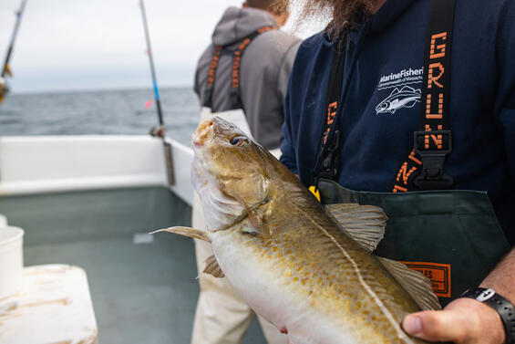
New Technique to Distinguish Cod Sub-Populations in the GOM
Recent genetic studies have shown us that there are two distinct sub-populations of cod that live in the Gulf of Maine. Although these groups spawn in opposite seasons (“spring cod” in May–June; “winter cod” in November–December), they intermix for much of the year and both are caught by Massachusetts fishermen. The lack of a practical tool to discriminate between the two groups has, to date, prevented us from addressing this complex population structure in fishery management plans and stock assessments.
In response to this need, DMF biologists have developed a technique that uses internal measurements from cod otoliths to reliably distinguish between the two sub-populations. Because of their spawning time, winter cod have a six-month head start in growth before laying down their first otolith growth ring, or annulus. By looking at this natural marker on otoliths taken from adult spawning cod, we accurately assigned individuals to their sub-population 81% of the time and could estimate the sub-population mixture of a sample of fish within 1%.
As a demonstration of its utility, we applied this technique to over 1,600 cod captured from DMF’s industry-based bottom trawl survey, which intensively sampled the cod populations of the Western Gulf of Maine during two separate periods (2003–2007 and 2016–2019). We found that the system of closed areas has mostly favored spring cod in recent decades, which caused the fishery to harvest predominantly from the winter sub-population. This difference in mortality rates has allowed spring spawners to live longer and achieve larger sizes than their winter-spawning counterparts. Currently, nearly all cod over eight years old are from the spring sub-population.
Interestingly, this survival advantage has not resulted in more spring cod over time. In fact, the spring sub-population currently represents only 14% of the Gulf of Maine cod stock, compared to 50% some 15 years ago. It appears that the spring spawners have been unable to create a strong year class in recent years. This pattern is corroborated by a distinct lack of spring cod juveniles in our inshore trawl survey, which covers the cod nursery grounds. In addition to these sub-population differences in survival and productivity, we also found that winter spawners grow and mature at a significantly faster rate.
We are hopeful that this simple new method will be applied broadly to federal archives of cod otoliths collected from the fishery and regional resource surveys. This will allow for a greater understanding of how changes in sub-population mix of Gulf of Maine cod impact our efforts to manage the fishery and assess this key stock. This study was recently published in the ICES Journal of Marine Science.
By Micah Dean, Marine Fisheries Biologist
How DMF Preserves Angler Access to Fishing
The angling public has become accustomed to purchasing their saltwater fishing permit. What many may not know is that one-third of the $10 permit fee is dedicated to preserving and enhancing public access to saltwater recreational fishing opportunities. All of the public access projects that DMF funds go through a vetting process to ensure that revenue from permit sales is being spent wisely, including oversight by a citizen advisory panel.
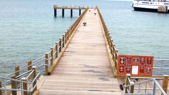
Since securing this source of revenue, DMF has strived to distribute funds equitably, both geographically and socio-economically. To date, we have completed projects from our northern border with New Hampshire to our southern border with Rhode Island, including Cape Cod and the Islands. In all cases, project dollars have only been spent in places that have equal access to all persons, regardless of their residency. All the structures that permit fees have funded are also Americans with Disabilities Act (ADA) compliant, with notable architectural features being the inclusion of railings that are lower than typical with extended planking for wheelchair-bound anglers and benches on our longer piers for those needing a rest along the way.
Many people have seen pictures of what has come to be called the most photographed spot on Martha’s Vineyard, the Oak Bluffs Fishing Pier. Since this flagship pier was completed, DMF has funded a new fishing pier at Wilbur Park in Yarmouth on the Bass River. Rumor has it that this is a great early season spot to catch schoolie striped bass. In addition, public access funds have paid for the rebuilding of the fishing pier at the mouth of the Bass River at South Shore Drive in Yarmouth and the fishing pier at Cashman Park in Newburyport. Angling at the South Shore Drive pier often results in catches of striped bass, summer flounder, scup, black sea bass, and many other fish. Cashman Park is a great place to catch striped bass and witness the occasional jump from one of the resident sturgeon in the Merrimack River. This August, we will be breaking ground on Deer Island in Boston Harbor for a new 260-foot long fishing pier that will be a phenomenal spot to catch striped bass and winter flounder.
To complement our large infrastructure projects, DMF funds a small projects grant program. Through this program, municipalities and other non-government entities can apply for funds to pay for projects costing up to $15,000 to improve opportunities to fish in saltwater. To date, DMF has awarded 24 grants equaling $300,000. Projects that have been awarded include lighting at launch facilities, landscape architecture to improve pathways, fish cutting stations, floats to fish or launch kayaks from, and more. Most recently, we awarded $50,000 in grants to saltwater fishing access projects in the following four coastal communities:
- City of Beverly: A $15,000 grant is funding maintenance on the existing pier abutting the harbormaster’s office that allows recreational fishing. This pier is a popular location to fish for striped bass, squid, winter flounder, and mackerel.
- City of Lynn: A $15,000 grant is funding the installation of a solar pathway and overhead lighting on the pier at the Lynn Heritage State Park. This popular fishing location is managed cooperatively between the City of Lynn and the Department of Conservation and Recreation. This project will make it safer for nighttime fishing.
- City of New Bedford: A $15,000 grant is funding the installation of overhead lighting at the Gifford Street Boat Ramp. This city-owned and managed ramp will be a safer place to launch and retrieve boats at night. The ramp is protected from wind and waves inside the New Bedford Harbor dike, making it a preferable boat launching location when conditions make other New Bedford boat ramps less desirable.
- Town of Marshfield: A $5,000 grant is funding the addition of kayak racks at Green Harbor and Peter Igo Park. These amenities will enable overnight and seasonal storage of kayaks, complementing improvements that have taken place at the Green Harbor State Ramp, the Green Harbor Walkway, Harbor Park, and Peter Igo Park in the Green Harbor area over the past decade.
Division staff facilitates public access in a number of ad hoc situations as well. For example, we occasionally get calls that municipalities want to close down fishing in public areas for one reason or another. In these instances, we work with the municipalities to keep the area open if possible, often with very little money. In one town, all it took was the purchase of garbage pails and liners for just over $100 to keep a pier open! The public is encouraged to call DMF with any questions, concerns, or suggestions regarding public marine fishing access in the Commonwealth.
By Ross Kessler, Public Access Coordinator
Additional Resources
2019 Northeast Regional Shellfish Conference Hosted by DMF
On April 9 and 10, DMF and the MA Department of Public Health (DPH) hosted the 2019 conference for our region’s Northeast Shellfish Sanitation Association (NESSA). Over 100 participants representing state and federal regulatory bodies, the shellfish industry, scientific research institutions, and NGOs from the six northeastern states from New Jersey to Maine attended the event in Plymouth. This regional meeting is held every year by a member state and is an important tool providing regional stakeholders the opportunity to discuss shellfish sanitation issues and develop consensus on issues of mutual interest.
Regional consensus from these annual meetings is critical, as member states attend the Interstate Shellfish Sanitation Conference (ISSC) every two years. At these biennial meetings, members take up proposals to amend and update the National Shellfish Sanitation Program’s (NSSP) Guide to meet emerging public health challenges and changing industry needs. The NSSP Guide sets forth the regulatory framework and guidelines by which states must control and manage the harvest, handling, and sale of molluscan shellfish in order to be deemed suitable for public consumption and interstate commerce. As a cooperative program, the standards in the Guide are voted on and adopted by member states with the US Food and Drug Administration (FDA) concurrence. State compliance with the NSSP is evaluated by the FDA. The NSSP is the federal/state cooperative program recognized by the FDA and the Interstate Shellfish Sanitation Conference (ISSC) for the sanitary control of shellfish produced and sold for human consumption in the US.
DMF Director David Pierce provided welcoming comments to the conference. He pointed out that DMF Shellfish Program’s priorities and actions are influenced by many factors that have evolved over the multi-decadal history of the program. Looking forward over the next five years, the Shellfish Program will be addressing the following ongoing and emerging issues:
Increased public demands to assist communities in identifying pollution sources and to conduct more frequent sanitary surveys for re-classification of waters for harvest;
Changing ocean conditions effecting the abundance of shellfish, the threat of shellfish disease, and the risk to public health;
Coastal development coupled with flooding and sea level rise placing nearshore shellfish at risk of more frequent closures especially if sanitary infrastructure gets overwhelmed as has been seen in recent years; and
Competing ocean uses and concerns related to growth in marine aquaculture (both shellfish and non-shellfish) reducing access to open waters for traditional wild capture fisheries.
The Director pointed out that to be successful the Shellfish Program must work simultaneously with other entities at five levels: federal mandates from FDA, state officials from DPH, municipal officials from each of the coastal communities, industry members, and partner New England state shellfish authorities.
Throughout the two-day conference, attendees were provided an update on ISSC issues and a review of the FDA’s approach to creating uniformity while conducting NSSP Program Element Evaluations. Shellfish regulatory authorities from the six participating states provided summaries of key management and research activities undertaken within their home state, focusing on the sanitary control of shellfish produced and sold for human consumption.
There were also panel discussions relating to key aspects of the Guide that will be addressed at the upcoming 2019 ISSC Biennial Meeting being held in San Diego in October. Panel discussions included: classification of mooring fields and marinas; NSSP evaluation criteria for growing area classification; shellfish cleansing studies related to growing area classification; aquaculture and public health issues; regulatory changes to the offshore clam fishery; and biotoxin management and contingency planning.
Two ISSC training sessions were provided to conference attendees by DPH staff. Training sessions included instructions related to documentation of time/temperature monitoring upon receiving and transporting shellstock, and on proper record keeping and trace back methods in the event of a shellfish recall. To wrap up the conference, two field trips were offered which included tours of Island Creek Oyster’s new facility in Duxbury and Seawatch International’s clam processing facility in New Bedford.
DMF received many compliments on our organizing an informative and productive NESSA conference. The success of this year’s meeting was in part due to the thoughtful comments and responses raised by the NESSA membership during Q&A sessions. In response to multiple requests received since the meeting, the agenda and most of the presentations (PDF format) can be found on the DMF website (https://www.mass.gov/lists/2019-northeast-shellfish-sanitation-association-annual-meeting).
By Tom Shields, South Shore Regional Shellfish Supervisor & 2019 NESSA President
Additional Resources
Your Recreational Saltwater Fishing Permit Fees at Work
One of the more common questions we get here at DMF is “how is the money from my recreational saltwater fishing permit used?” The most straightforward answer is that all funds are used to promote and protect the recreational saltwater fishing community of Massachusetts, so it truly does come right back to all permitted anglers! The more intricate answer is that all revenue from the permit goes into a dedicated Marine Recreational Fisheries Development Fund, which was created by legislation in 2011 when the permit was established. This “Saltwater Act” mandates that these funds can only be used for the purposes of improving recreational saltwater fishing in Massachusetts.
Thanks to this dedicated and protected fund, numerous projects are supported by your permit fees. This includes enhanced data collection on recreational catch, restoration of fish runs for species that utilize freshwater pathways for spawning, the construction and placement of artificial reefs, and saltwater angler education.
The largest expenditure from the Fund is used for projects designed to increase public access to saltwater fishing opportunities. The Saltwater Act further directs on the use of funds, requiring one third of the revenue be spent on these fishing access improvements. Your funds are directly responsible for building and maintaining public access fishing piers, repairing and improving boat launches and ramps, and securing and maintaining shore-side fishing areas. We also provide money in the form of small grants to municipalities and other entities for improvements to fishing access such as lighting, shore side brush clearing, float replacement, and installation of fillet stations.
Spending from the Fund is overseen by the Marine Recreational Fisheries Development Panel. This panel is composed of five individuals that are closely allied with recreational saltwater fishing. Current members are Patrick Paquette (President of Massachusetts Beach Buggy Association), Mike Moss (President of the Massachusetts Sportsmen’s Council), Mike Pierdinock (charter captain), Kalil Boghdan, PhD (saltwater fishing enthusiast), and Kevin Blinkoff (Executive Editor of On The Water Media Group). The Panel serves recreational saltwater anglers in Massachusetts by providing input on how permit money is spent through regularly scheduled meetings and communications with DMF.
We take pride that the recreational saltwater fishing permit program was implemented as a “user-pays, user-benefits” model. All permit fees are dedicated to improving the Massachusetts recreational saltwater fishing experience, and we hope you agree that it is money well spent. We’ll see you out on the water!
By Michael Armstrong, PhD, Assistant Director
Additional Resources
Offshore Wind Update
Activities for offshore wind development started to pick up the pace in 2018 (see DMF News Volume 41). Progress has continued at a steady rate this year—the 10th in which DMF has been involved in reviewing offshore wind activities. Here’s the latest on recent project development in the Northeast.
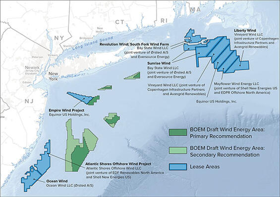
The Massachusetts Wind Energy Area
- The Mass Wind Energy Area has a total of five lease blocks, one of which has been leased to Vineyard Wind, LLC who is proposing to build a project called Vineyard Wind, and one to Ørsted who has partnered with Eversource to propose to build a project called Bay State Wind. The three remaining lease areas were auctioned off in December of 2018 to Equinor, Mayflower, and Vineyard Wind. The lease sale generated $405 million.
- The Vineyard Wind project south of Martha’s Vineyard is furthest along in planning and permitting. Many project details have been determined in the past year. The current plan includes developing 84 turbines, 1 electrical service platform, and two offshore export cables coming ashore to Covell’s Beach in Barnstable. The cables are scheduled to be laid across Nantucket Sound in the fall of 2020 and through Muskeget Channel in the spring of 2021. Construction is expected to begin at the end of 2019 and finish by the end of 2021. The turbines are planned to be in organized rows with an average distance of 0.8 nautical miles apart with 1 nautical mile transit corridors crossing the area. Future build-out is expected to follow an East-West orientation with a minimum of 1 mile spacing between turbines.
- Vineyard Wind received its Rhode Island federal consistency certificate in March, in which fisheries mitigation commitments were laid out. The project is now in the final stages of state permitting in Massachusetts, having received a Secretary Certificate for the Final Environmental Impact Report in February 2019 and the Energy Facilities Siting Board final decision in May 2019. Decisions for the Massachusetts federal consistency certificate and MA DEP combined Ch. 91/401 Water Quality Certificate are expected this summer. For federal permitting, the Final Environmental Impact Statement is also expected this summer.
- The Bay State Wind project submitted their Construction and Operations Plan this spring but it is still in completeness and sufficiency review with the Bureau of Ocean Energy Management (BOEM) and is expected to be available soon. Initial plans are for a wind farm with about 100 wind turbines with cable landfall at Brayton Point in Somerset. The turbines will be laid out in an East-West orientation with a minimum of 1-mile spacing between turbines. They will be doing survey work this summer, and expect to be producing power in 2023.
The Rhode Island-Massachusetts Wind Energy Area
- To the west, the RI-MA Wind Energy Area was leased by Orsted (formerly Deepwater Wind). Two wind farms are in the planning and permitting stages and are co-owned by Eversource: South Fork and Revolution Wind.
- Orsted-Eversource has a Power Purchase Agreement for 90 MW of South Fork wind energy with Long Island Power Authority. The Draft Environmental Impact Statement is expected soon and construction on South Fork is expected to start in 2021.
- Revolution Wind is a 400 MW project (about 50 turbines) expected to start permitting in 2019 and begin offshore installation in 2021.
New York Bight
- In New York, the state is supporting the development of 9,000 MW of offshore wind by 2035.
- Equinor Wind (formerly Statoil Wind) was the winner of a lease auction held in December 2016 and is proposing to build Empire Wind, with about 100 turbines in the 10–15 MW size range. Their Site Assessment Plan was approved by BOEM in November 2018.
- The planning process for wind energy areas is still ongoing in the New York Bight, and Draft Wind Energy Areas are being discussed.
Other
- New Hampshire has requested an Intergovernmental Task Force be developed to start the planning process for wind energy areas in the Gulf of Maine.
- The USCG has initiated a Port Access Route Study for the MA Wind Energy Area. Public meetings were held in the spring of 2019 and the study is expected to be finished in early fall 2019.
- Massachusetts Clean Energy Center and BOEM have committed $400,000 each for regional research focused on fisheries. Rhode Island Department of Environmental Management has committed $200,000. Two Massachusetts Fisheries Working Group meetings and one public comment period have been held to scope these studies. The Request for Proposals is expected this summer.
For more information, please contact Kathryn Ford (kathryn.ford@mass.gov, 508-742-9749).
By Kathryn Ford, PhD, Fisheries Habitat Program Leader
DMF’s 2019-2023 Strategic Plan Now Available!
DMF’s Strategic Plan for 2019-2023 ensures the work of the Massachusetts Division of Marine Fisheries remains focused on its mission and vision. It emphasizes marine fisheries leadership that DMF brings to the region on behalf of the Commonwealth. It stresses the protection of the marine environment and habitats; preservation and enhancement of commercial and recreational fishing opportunities; improving the science on which marine fisheries policy and management decisions are based; and confronting new challenges and requirements for our increased involvement with early 21st century state and federal initiatives, such as promotion and expansion of marine aquaculture and responsible offshore wind energy development.
To read the entire plan using the link below.
By David Pierce, PhD, Director
Additional Resources
-
Open PDF file, 1.84 MB, DMF Strategic Plan 2019-2023 (English, PDF 1.84 MB)
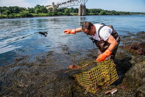
Ghost Gear Clean Up at the Cape Cod Canal
This July, DMF divers suited up to help protect our fisheries from ghost fishing gear in partnership with the Army Corps of Engineers. Ghost fishing happens when gear like lobster traps are lost or abandoned, but still continue to catch marine life. Even though the ghost traps aren’t pulled out regularly, lobsters still find their way in to the traps and can’t get out. Trapped lobsters often fight and kill each other or are eaten by predators that follow the lobsters into the trap, becoming trapped themselves.
Because of strong currents and lack of buoys, ghost fishing gear can easily end up in the Cape Cod Canal. The divers from DMF waded into the water below the Sagamore Bridge and pulled out nearly two dozen illegal and derelict traps in under an hour. The illegal traps were removed because of a key problem that causes even more ghost fishing. Lobster traps have escape vents, which are covered while the traps are in use, but are designed to allow lobsters to escape if the trap becomes lost or abandoned. The cover is required to be held on using a metal that will degrade over time, so that it can release if the trap becomes ghost gear. The illegal traps used zip ties and stainless steel fasteners that don’t degrade enough over time to allow ghost-fished lobsters to escape, making those traps dangerous ghost gear. Several other traps lacked their identification tags.
Many of the traps were also wrapped up with recreational hook and line gear, which often gets caught among the rocks as well as on the traps themselves. The divers pulled out dozens of jigs and lures that fishermen had cut from their lines after getting stuck.
By removing the illegal lobster traps and ghost gear, DMF and the Army Corps of Engineers are helping to secure a future for lobsters and lobstermen alike. Using stainless steel fasteners can seem like a good idea in the short run for lobstermen, but it can easily lead to needlessly dead lobsters, hurting the fishery overall. Preventing ghost gear helps keep our lobster stock healthy to support fishermen, the ecosystem, and lobster lovers across Massachusetts.
By Tim Briggs, Seafood Marketing Intern
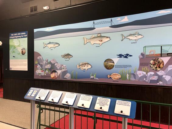
New Marine Fisheries Exhibit at the Sandwich Visitor Center
This spring, DMF installed an educational marine fisheries exhibit at the Army Corps of Engineers Cape Cod Canal Visitor Center. The exhibit focuses on the canal as a highway for marine species, as well as fishing in the canal. Opening of the exhibit coincided with the center’s 14th annual Water and Boating Safety Day. We are excited to be a part of the Army Corps of Engineers Visitor Center, which sees about 35,000–40,000 visitors each year! We are also looking forward to expanding our interactive display over the next year.
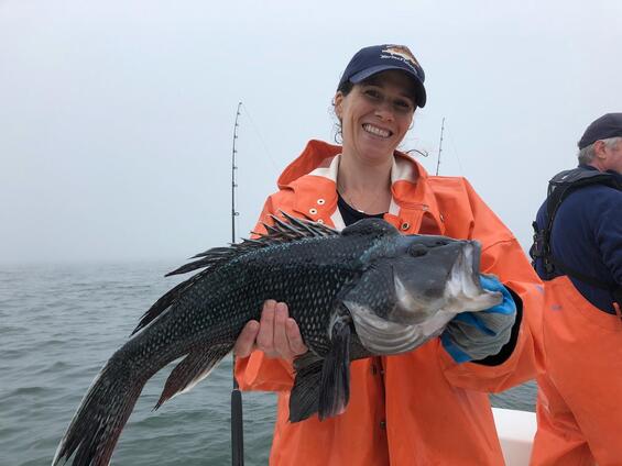
Creature Feature: Black Sea Bass (Centropristis striata)
Description
The black sea bass is a member of the family Serranidae, which includes the true sea basses and groupers. Although this species is closely related to the Goliath grouper, which can weigh several hundred pounds, it is much smaller and rarely grows bigger than five or six pounds. Black sea bass are stout-bodied with a long dorsal fin and large pectoral and pelvic fins. Be careful when handling these fish because of their very sharp dorsal fin spines and opercula (gill covers). Unlike striped bass, black sea bass have one continuous dorsal fin, which is notched between the forward spiny section and the soft rays of the rear section. The dorsal fin is also marked with a series of white spots and bands. The tail is rounded and sometimes has a long streamer at the top edge. As the name implies, their body coloration is blackish to grayish, but the center of the scales is white. However, during the spawning season, dominant males turn bright blue colors and have a large hump on their heads. Juveniles are brown in color and have a dark lateral stripe running down the body.
Distribution and Habitat
The black sea bass is a temperate fish and can be found along the U.S. east coast from Maine to Florida. They winter in deep water off the coast of the mid-Atlantic states. In the spring, large schools migrate northward and inshore, generally arriving in Massachusetts waters sometime in May. Adult sea bass then take up residence over rocky bottoms or anywhere some structure can be found in depths of less than 150 feet. They are abundant in Massachusetts waters until October, with the largest concentrations found in Buzzards Bay and Nantucket and Vineyard Sounds. Juvenile and young-of-the-year sea bass tend to prefer estuaries, where they feed and avoid predators.
Life History
Black sea bass are protogynous hermaphrodites, meaning most fish start life as females and change into males (generally once they reach 9–13 inches). This change takes place over the fall and winter after spawning has ended, and is thought to be based on visual rather than chemical cues. Black sea bass are fast growing and most are sexually mature by age three. Males attract a group of females to mate, often referred to as a harem, and aggressively defend their territory. Spawning in Massachusetts occurs in late spring and early summer in relatively shallow water. Large females are capable of producing up to half a million eggs. Sea bass eggs are buoyant and float in the water column for only a few days before hatching into larvae that then settle in nearshore waters. After settling, the young juveniles migrate to estuaries where they grow and develop throughout the summer and early fall.
Like striped bass, black sea bass have large mouths but lack any large teeth. Also similar to striped bass, black sea bass don’t bite their prey but swallow it whole. They are aggressive feeders and generally stay close to the bottom though it is not uncommon to see them feeding on baitfish at the surface. Black sea bass are opportunistic predators and feed on a variety of small fishes as well as crustaceans and squid. They grow up to 25 inches and can live 10–12 years. Large specimens can exceed 8 pounds, but the majority of fish caught weigh less than 4 pounds. The current Massachusetts Saltwater Derby record is 8 pounds 14 ounces, caught in 2007 (https://www.mass.gov/saltwater-fishing-derby).
Management
Black sea bass are highly sought after by both commercial and recreational fishermen. They are managed by the Atlantic States Marine Fisheries Commission and the Mid-Atlantic Fishery Management Council. The management plan divides the total annual quota between the recreational fishery (51%) and the commercial fishery (49%). Recreational regulations, including an open season, bag limit, and minimum size, vary by state and are adjusted annually to achieve the harvest limit. Anglers participating in Massachusetts’ 2019 recreational fishery are limited to 5 fish per day and a minimum size of 15” during the open season of May 18–September 8. The coastwide commercial quota is divided into annual state-by-state quotas based on historical harvests (MA=13%), with specific management measures set by each state. In Massachusetts, the commercial fishery is limited entry and commercial fishermen are regulated by an open season and open fishing days, a daily possession limit, and a minimum size. In 2018, Massachusetts recreational anglers harvested an estimated 1.8 million pounds of black sea bass (the highest among all states), while commercial fishermen harvested over 480,000 pounds (105% of our quota).
The most recent stock assessment of black sea bass was conducted in 2016. The spawning stock biomass (abundance of mature males and females) was estimated to be roughly 2.3 times the target spawning biomass level in 2015. This led to a significant coastwide quota increase in 2017. Both recreational and commercial fisheries are achieving their limits which has provided for largely status quo regulations since. An update to the stock assessment is planned for this year, which will include a new time series of recreational harvest estimates based on improvements made to the survey that produced these data. The results of this assessment will be used to set the catch and landings limits for the next few years. Managers will take into account many different factors including recruitment, year class strength, and a shift in biomass northward. Massachusetts has experienced some excellent black sea bass fishing for the past several years; with proper management, we should have a great fishery for years to come.
By John Boardman, Recreational Fisheries Biologist
Regulatory Updates
During the period of January 1, 2019 through June 30, 2019 the following regulatory changes were enacted by DMF after public hearings and Marine Fishery Advisory Commission (MFAC) approval or by the Director under his declaratory and emergency authorities.
Cape Cod Bay Seasonal Speed Limit Restricted Area
To reduce the risk of mortality to right whales by ship-strikes, a 10-knot speed limit has been established for vessels operating within Cape Cod Bay during the period of March 1 – April 30. The affected area includes those waters of Cape Cod Bay south of 42° 08’ north latitude and north and east of Cape Cod that are west of 70°10’west longitude. The state rule applies to all vessels with an overall length of less than 65’; vessels measuring 65’ and greater are subject to a similar federal speed limit regulation. The regulation includes a provision to adjust the timing of speed limit restriction in response to the presence or absence of right whales in the Bay. The speed limit was extend through May 9th to account for the continued presence of right whales in the area.
Commercial Groundfish Closures
The waters under the jurisdiction of the Commonwealth between Plymouth (42°00’ north latitude) and Marblehead (42°30’ north latitude) that are west of 70°30’ west longitude are closed to commercial groundfish fishing during the month of April. This closure is designed to realign the state-waters groundfish fishery’s landings with the federally allocated state-waters set-aside targets. The regulation includes a provision that allows for the closure to be rescinded if data demonstrates that the set-asides will not be exceeded nor federal conservation goals jeopardized for that fishing year. For 2019, the closure was rescinded.
Commercial Groundfish Endorsement Control Date
A December 31, 2018 control date has been established for the regulated fishery permit endorsement for state-waters groundfish. Subject to future rule making, this control date may be used to limit entry and participation in the state-waters groundfish fishery based on prior history.
Large Whale Seasonal Trap Gear Haul-Out Extension
In response to the continued seasonal presence of endangered right whales in the waters of Cape Cod Bay, DMF temporarily extended the large whale trap gear haul-out period from April 30th through May 9th for certain waters of Cape Cod Bay and the Outer Cape. This included those waters under the jurisdiction of the Commonwealth within Cape Cod Bay south of 42°8.42’ north latitude, as well as those waters under the jurisdiction of the Commonwealth east of Cape Cod north of 41°51.5’ north latitude. During this closure extension, the setting and abandoning of trap gear in these areas remained prohibited.
Mobile Gear Regulations
The state’s mobile gear fishery regulations were amended by updating the mobile gear closure rules to describe the closure boundaries using latitudinal and longitudinal coordinates. This rule change also specified that chafing gear may be used on the bottom of trawl nets and net strengtheners may be used in exempted small mesh fisheries. Lastly, the night closure was extend to include purse seine fishing, which was previously established through permit conditions.
Recreational Fishing Limits for Black Sea Bass
The recreational black sea bass season was adjusted so that it would occur during May 18 – September 8, rather than May 19 – September 12. By allowing the season to continue to open on the third Saturday in May four days in September were removed from the open season. The bag limit and size limit remained status quo at 5-fish and 15”.
Recreational Fishing Limits for Cod
The moratorium on the recreational retention of Gulf of Maine cod was lifted. Recreational anglers are now allowed to retain 1-fish measuring 21” during the period of September 15 – September 30. For Georges Bank cod, the minimum size was reduced from 23” to 21”. The year-round open fishing season Georges Bank cod remained status quo, as did the 10-fish bag limit.
Recreational Fishing Limits for Gulf of Maine Haddock
The recreational Gulf of Maine haddock season was adjusted to rescind the September 17 – October 31 closed fishing season, thereby allowing anglers to retain Gulf of Maine Haddock from April 15 through the last day of February. The bag limit was also increased from 12-fish to 15-fish. The minimum size stayed status quo at 17”.
Recreational Fishing Limits for Scup
The recreational fishing season was made less restrictive by rescinding the January 1 – April 30 closed fishing season to allow year-round opportunities to fish for scup. The May 1 – June 30 for-hire bonus-season bag limit was also increased from 45-fish to 50-fish. The minimum size and open season bag limit remained status quo at 9” and 30-fish.
Shellfish Recodification
The state’s shellfish regulations were re-codified to ensure explicit compliance with the National Shellfish Sanitation Program’s Model Ordinance. These new regulations describe shellfish growing area classifications; explain how growing areas are classified and harvest statutes are published and amended; establish rules governing the sanitary harvest, handling and transport of shellstock; explicitly allow for the bulk tagging by grower/dealers; and sets forth the shellfish relay program and statutorily mandated relay fee. Technical corrections were also made to the Vibrio management regulations.
Small Mesh Trawler Bycatch Limits for Scup
Vessels fishing with trawl nets with mesh measuring less than 5” diamond in the cod end were authorized to possess and land up to 1,000 pounds of scup from October 1 – April 14; 2,000 pounds of scup from April 14 – June 15, and 200 pounds of scup from June 16 – September 30. This change in bycatch limits is consistent with federal regulations and designed to increase the retention of market sized scup caught during the spring small mesh trawl fishery for squid. The prior limits allowed for 1,000 pounds of scup to be retained from October 1 – April 30 and 200 pounds of scup to be retained from May 1 – September 30.
Small Mesh Trawl Squid Seasonal Extension
DMF extended the season when trawlers may fish for squid using small mesh trawls in the waters south and west of Cape Cod by one week. Rather than closing on June 10th, the fishery remained open through June 16th to provide additional access to the large, market-sized squid that remained in the area.
Striped Bass Conservation
Two new striped bass conservation measures were implemented. Effective in 2019, fishermen are prohibited from gaffing any undersized striped bass or releasing any fish that has been gaffed. Effective in 2020, all private recreational anglers fishing with natural baits will be required to use circle hooks. The circle hook mandate will not apply to fishermen fishing with natural baits affixed to artificial lures (e.g., tube and worm) or using the snag and drop technique.
Striped Bass Importation
The rule restricting the importation of non-conforming sized striped bass during Massachusetts’ commercial striped bass season has been rescinded. Provided the fish are properly tagged and were lawfully caught in the jurisdiction of origin, they may be imported into Massachusetts at sizes smaller than 34”.
Whelk Minimum Gauge Size Increases
A 10-year schedule has been implemented to increase the minimum gauge width for knobbed and channeled whelks from 2 7/8” to 3 5/8”. The first gauge width increase occurred in 2019 with the gauge width being increased to 3”. The gauge will then be increased by 1/8” on a biennial basis until the terminal size is reached. The terminal 3 5/8” gauge width represents 50% size at maturity for female whelks. This action was taken to enhance spawning stock biomass protections, particularly as the recent stock assessment for channeled whelk found that they are overfished with overfishing occurring in Nantucket Sound, the principal harvest area.
Additional Resources
Adjudicatory Proceedings
Under state law, DMF may sanction commercial and recreational fishing permits for violations of the state’s marine fishery laws and regulations subject to a due process adjudicatory proceeding. These adjudicatory proceedings are held before a magistrate. They may be initiated by the agency, the Environmental Police, or municipal officials (constables) authorized to enforce the marine fishery laws of the Commonwealth.
From January 1, 2018 through June 30, 2019, DMF initiated 17 adjudicatory proceedings. These proceedings were initiated based on incident reports for violations of the state’s marine fishery laws and regulations. The violations to be adjudicated were: sub-legal sized whelk; angler non-compliance on for-hire vessels; possession of egg bearing and scrubbed lobsters; possession of v-notched and mutilated v-notched lobsters; possession of undersized and oversized lobsters; removal of shellfish from areas closed to commercial shellfish fishing; contaminated shellfish and the sanitary harvest of shellfish; non-conforming surf clam bycatch; sub-legal sized striped bass, black sea bass and tautog; striped bass, black sea bass and tautog over the limit; and failure to remove lobster trap gear from the Large Whale Seasonal Closure Area.
Of the 17 proceedings that were initiated, 13 were disposed of by June 30, 2019. The final decisions include determinations by the Director to: revoke a commercial lobster permit for failure to remove gear during the wintertime haul-out period to protect endangered whales; revoke two commercial shellfish permits for the harvest of contaminated shellfish; revoke a commercial fishing permit for black sea bass violations; suspend the commercial and/or recreational fishing permits of four individuals for striped bass violations with suspensions of one-to-three years; suspend a commercial fishing permits for black sea bass violations; suspend one for-hire permit from participating in the fall tautog fishery for a period for three years; and issue three sets of permit conditions to enhance angler compliance on head boat, and compliance with lobster and surf clam management regulations.