Habitat description
Gently-sloping cool rivers are characterized by large drainage areas and average summer water temperatures ranging between 18-22°C (stream order > 4, slope < 2%). Generally found in areas with wide floodplains at mid-elevations and upstream of larger warmwater rivers. Substrates in these systems are dominated by sand and gravel.
Characteristic communities and species
Fish communities typically include white sucker, fallfish, common shiner, longnose dace, tessellated darter, and creek chub, although not all species may be found at all sites. Popular game fishes include rock and smallmouth bass. Freshwater mussels can include creeper, triangle floater, eastern elliptio, eastern lampmussel, eastern pearshell, and at a few stream segments the state endangered brook floater. Trypical dragonfly species include stream and Swift River cruisers, twin-spotted spiketail, fawn and springtime darners, species of snaketails, hanging, bantam and American clubtails, and black-shouldered spinylegs, shadowdragons, Uhler's sundragon among others.
View a complete list of Species of Greatest Conservation Need associated with this habitat.
Associated habitats
Ecological Processes
As smaller tributaries come together to form larger rivers, stream channels get deeper and wider. The cooling effect from groundwater and shaded banks weakens, resulting in warmer water temperatures, although colder pockets still often exist. Large trees falling into the channel continue to be important for the creation of habitat complexity, but primary productivity begins to shift from being largely dependent on riparian vegetation inputs to also being supported by within channel components such as algae and aquatic vegetation. At mid-elevations, coolwater river floodplains are set further back from the river channel than upstream and meanders in the channel begin to form. These gently-sloping rivers can experience significant sedimentation after large storms from high rates of erosion so changes in channel structure are not uncommon. In undammed rivers, sediment flush through the system during subsequent storms.
Threats
- Climate change: Continued changes in precipitation patterns due to climate change are strengthening the impact of floods and droughts. Channel scouring will likely become more significant in winter and spring. Water depth is likely to decrease significantly in summer and fall, with decreased pool depths. Shallower depths combined with warmer summer and fall temperatures may turn cool water reaches into warmwater habitats at least seasonally.
- Invasive species: Other threats include invasive species that have changed fish community composition in some rivers. For example, cutlip minnow, native to more southerly states, is now the most abundant species surveyed in the West Branch Farmington River.
- Dams and urbanization: Dammed reservoirs, road drainage and wastewater can become warmwater inputs. Dams can become barriers to species migrations, alter streamflow regimes, and disrupt sediment and nutrient cycles. Sand from roads can impact substrates. Land use changes and vegetation clearing in the floodplain, and channel and bank alteration are also threats.
Conservation actions
- Proactive habitat protection: Protect buffers adjacent to gently sloping cool rivers, control stormwater inputs, and minimize siltation and erosion. Protect mature gently sloping cool rivers and other associated, interconnected habitats to maintain healthy and resilient landscapes for people and biodiversity conservation. Prioritize sites supporting SGCN, as well as other protection priorities identified in BioMap and other conservation planning tools.
- Habitat restoration and management: See recommendations below.
- Law and policy: Regulate and limit the impacts of shoreline development, pollutants, and water withdrawals on these waters. These rivers need more of a watershed approach to regulation and conservation and the cooperation of agencies, partners, and municipalities to bring about restoration. Incentivize the protection and maintenance of gently sloping cool rivers on private and public lands. Regulate and limit the impacts of development and consider innovative approaches to incentivizing compatible development where applicable.
- Conservation planning: Include gently sloping cool rivers in conservation planning efforts at multiple spatial scales. (See BioMap as an example.)
- Surveys, monitoring, and research: Monitor the health and trends of SGCN populations, plant communities, and other wildlife. Monitor the effectiveness of habitat management efforts and conduct targeted research to improve habitat and population management.
- Public outreach and education: Educate state residents about the ecological nature of gently sloping cool rivers including climate change impacts. Educate and inform the public about the values of gently sloping cool rivers for biodiversity and water resource conservation through agency publications and other public outreach.
Restoration & management recommendations
- Water quality restoration: Treatment of wastewater and limited use of road sand and salt next to rivers can help protect their water quality. However, restoration of hydrologic and morphological processes is only relevant within the context of the upstream watershed. Coordinated, comprehensive restoration efforts will benefit from watershed-scale conservation planning.
- Dam removal: Dams affect all large coolwater rivers in the state, both directly when located in river or indirectly when located in tributaries.
- Invasive plant control:Prevention is the best management strategy for reducing the introduction of invasive species into large coolwater rivers.
- Floodplain restoration: Conditions in large, coolwater rivers benefit from connections to their floodplains. Floodplain restoration actions may include “daylighting” of tributaries in urban areas, channel and shoreline restoration, replacement of paved surfaces with permeable materials, and removal of invasive species. Whenever possible, road surfaces should allow infiltration into the ground rather than divert directly to stream channels. Improvements to channel function can be made at local scales, for instance through installation of instream habitat structures.
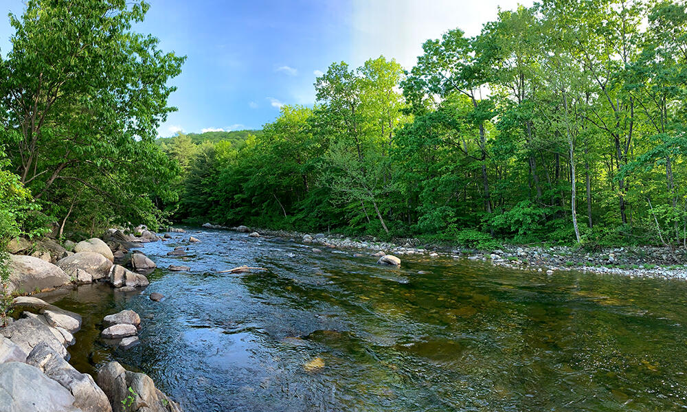
Examples
Examples of gently-sloping cool rivers in Massachusetts include the North Nashua, Westfield (downstream of Russell), Millers (between Winchendon and South Royalston; pictured above) and West Branch Farmington Rivers (between Otis and the northern boundary of the Sandisfield State Forest).