Overview
The project’s primary end goal is to improve safety along the corridor for all roadway users.
After reviewing safety issues, the RSA provides a list of short-term (<1 year), mid-term (1-3 years), and long-term (>3 years) improvements along the corridor. The full list of recommendations can be found in the RSA reports; MassDOT has been coordinating internally to accomplish as many of the short-term enhancements as possible in the next year.
Following the RSA, the next task at hand was to perform data collection along the entire corridor. Traffic counts were taken at all signalized intersections in spring/summer 2022 to determine what improvements could be made with signal timing updates.
First Tier Implementation – Fall 2022 Through Spring 2023
The first tier of improvements will be implemented in a “quick-build” manner, and these are limited to improvements that do not require any right-of-way impacts, new conduit trenching, or private business access impacts to be able to implement within this construction season.
The major scope of work will include new pavement markings, signage updates, speed feedback signs, and signal phase timing improvements to accomplish the following from the RSA:
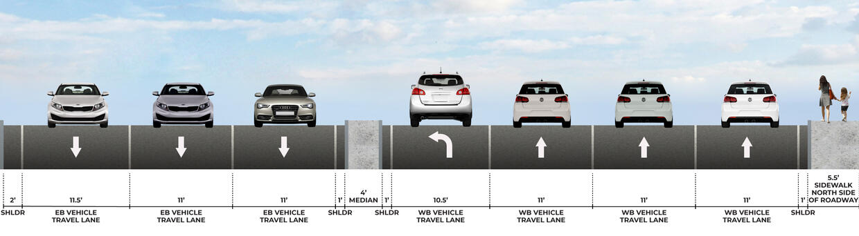
- Provide speed reduction measures for the entire corridor through a narrowing of lanes from 12+ feet wide to 11 feet wide in the outside lane, as well as speed feedback signs.
- Evaluate the best location for two-way left-turn lane and create visual breaks in the two-way left-turn lane to discourage excessive travel within it.
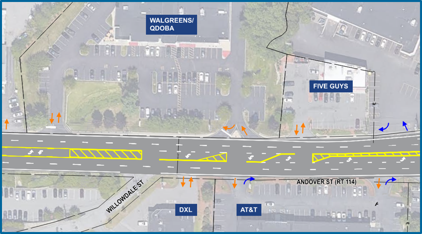
- Consider where signage needs to be supplemented or replaced to reduce driver confusion.
- Evaluate the best location for two-way left-turn lane and create visual breaks in the two-way left-turn lane to discourage excessive travel within it.
- Consider where signage needs to be supplemented or replaced to reduce driver confusion.
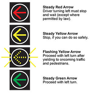
- Evaluate permissive left-turn lanes and provide a protected phase for drivers to take lefts without conflicts with through travel in the other direction; when protected phases are not possible, provide “Left Turn Yield on Flashing” to clarify permissive movements.
- Provide retroreflective backplates to signals.
- Check all clearance times (yellow and red times) for the signalized intersections.
- Refresh pedestrian crossing pavement markings and provide additional signalized pedestrian crossing where necessary crossing Route 114 based on pedestrian desire lines.
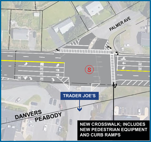
- In Tier 1, new crosswalks will be provided across Route 114 at Garden Street and Palmer Avenue based on the presence of adequate right-of-way and traffic signal equipment to connect to.
- Existing crosswalks across side streets and across Route 114 at Brooskby Village and Loris Road.
Signal phase timing was specifically evaluated for the following:
Review Pedestrian Clearance Times toReduce pedestrian collisions
Review Yellow Clearance Times to Reduce rear-end collisions
Review All-Red Clearance Times to Reduce angle and head on collisions
Review Left Turn Phasing to Reduce angle and head on collisions
Review need for three through lanes for consistency along the corridor to Reduce sideswipe collisions at merge points
No Turn on Red Signs to Reduce angle collisions
Additionally, the traffic analysis performed revealed excess capacity on the corridor in certain locations. The Tier 1 Improvements will remove these extra lanes using pavement markings to reduce crashes associated with weaving, merging, and turning due to the additional conflict points. The reclaimed space may be reclaimed for multi-modal uses in future reconstruction projects.
Lane Removal Evaluation
The traffic analysis performed during design of the First Tier Implementation suggested that the third lane between Sylvan Street and the 128 ramps could be removed without adding significant delay to the corridor. Since the "pilot" removal of this lane in mid-October, MassDOT has been evaluating the traffic impacts to determine what should be implemented in the final condition. MassDOT has sent out staff to perform spot observations and run test travel times, as well as utilized probe data from our Regional Integrated Transportation Information System (RITIS). Public feedback has also been used to evaluate the pilot lane removal, which has come through emails and the feedback survey posted on the website, which will be closed at the end of January. Currently, there is a disconnect between the delay being reported by residents versus what has been witnessed during MassDOT field visits and summarized from regional data. Video units were deployed in December to allow for 24/7 monitoring of the corridor to bridge this gap.
The pilot lane removal has only been in place for a few months, which has not given drivers time to adjust to the new lane configuration, which was exacerbated by holidays. MassDOT plans to continue evaluation of the lane removal for a few more months to feel comfortable that impacts are understood and an informed decision can be made. There will be a public meeting to discuss the full evaluation when it is complete, and to discuss the Second Tier of Implementation. This date is TBD.
Second Tier Implementation – Spring/Summer 2023
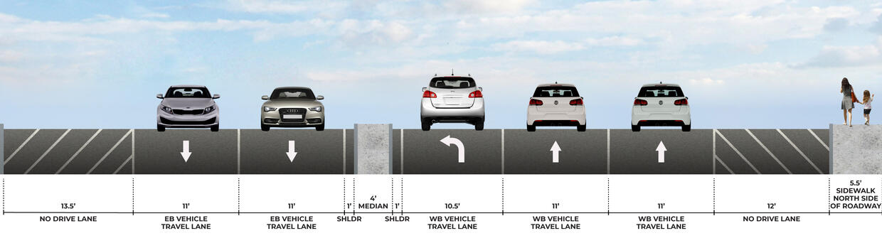
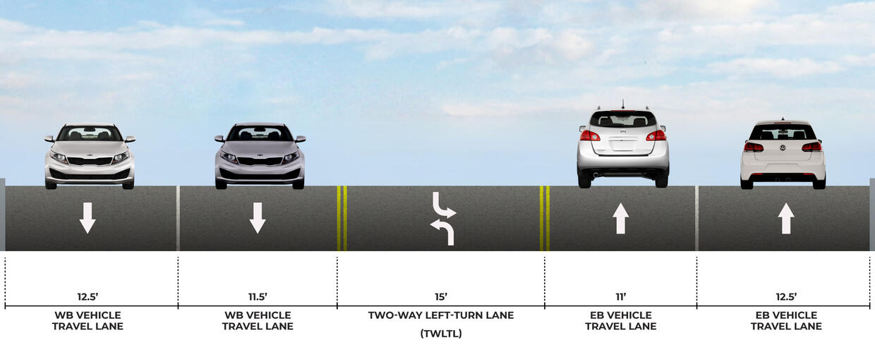
The next planned phase of implementation will be in Spring/Summer 2023 when there has been ample time to verify right-of-way, coordinate with stakeholders and the community, and plan for more significant construction as needed. These improvements will target more of the safety associated with access management and provide more opportunity for pedestrian enhancements. Most notably, the corridor will be micro surfaced to allow for all new pavement markings, including a change to the cross section as shown below.

Other improvements may include the following from the RSA list:
- Restricting left-turns from unsignalized full-access driveways using signage and pavement markings.
- Restricting left-turns from unsignalized full-access driveways using channelizing delta islands.
- Provide a pilot median using flex posts along the corridor at locations with high potential for conflict and/or significant crash history from the RSA.
- Consider the need for additional u-turn locations throughout the corridor in coordination with any left turn restrictions to provide adequate access.
- Address roadway lighting and replace or upgrade where necessary.
- Evaluate existing sidewalk conditions to ensure ADA compliance and improve sidewalk conditions.
Long-Term Improvements
Other improvements as recommended in the RSA require a more long-term approach due to the needs for right-of-way acquisition, significant geometric changes and reconstruction, and permitting. These may include:
- Consolidate driveway access for businesses close in proximity to reduce conflict points.
- Consider aligning the intersections at a 90-degree angle which are at acute angles.
- Provide sidewalk along the south side of Route 114.
- Evaluate the potential for bicycle accommodations along Route 114 (ex. Buffered bike lanes and shared use paths).
- Consider locations where the two-way left turn lane could be replaced with a raised median along Route 114.
- Perform a study and consider a signal at the Route 114 at Mt Pleasant Drive intersection.
- Construct a roadway connecting Lowell Street to Route 114 in Peabody to reduce the amount of cut-through traffic using Mt Pleasant Street.
- Perform a signal warrant study for the intersection of Route 114 at the I-95 northbound ramps and consider implementation of a signal to reduce potential angle collisions.
- Where necessary, provide smaller radii and realignment of ramps to improve driver visibility when merging.
Next Steps
- Fall 2022: Resurfacing and pavement markings for lane diet, signal updates, existing crosswalk improvements, curb ramp improvements, targeted new crosswalks
- Coming Soon! Public Information Meeting about Spring/Summer Improvements
- Spring/Summer 2023: Construction for increased access management, more pedestrian crossing opportunities, some sidewalk construction to connect to destinations on south side of Route 114