The Challenge
The Commonwealth’s historic system of parkways is vulnerable to the effects of climate change. A Parkways Climate Vulnerability Assessment can provide the first step into planning-level flood risk information specific for the DCR Parkways system by identifying risks from flooding under future climate scenarios, aligning with the 2022 Massachusetts Climate Assessment. Such an assessment would supplement the 2020 DCR Parkways Master Plan to add long-term considerations in the context of the exposure to extreme weather and climate effects, and adaptive capacity.
Project Scope
This project consisted of developing a methodology to analyze climate change exposure, sensitivity, and vulnerability risk for the DCR Parkways System, based on the 2022 DCR Statewide Climate Change Vulnerability Assessment, the 2022 MA Climate Assessment, the 2023 ResilientMass Plan, and the most up-to-date and best available statewide climate change projections including but not limited to the data, metrics, and algorithms in the Resilient MA Action Team’s Climate Resilience Design Standards and Guidelines (RMAT Tool), MassDOT MA Coast Flood Risk Model, the 2021 EEA Climate-Hydrology Risk Projections for precipitation and temperature, and the Federal Highway Administration Vulnerability Assessment and Adaptation Framework.
The assessment considers damage and repair costs, time estimates for repairs, and the consequences from loss of service. In addition to the recreational value, this study estimates the “do nothing” costs and qualitative consequences of at-risk transportation assets under future conditions assuming no intervention. Part of the scope also includes developing traffic counts, outreach materials including an ArcGIS Online viewer, and public meetings to inform and engage staff and the public in the development of this product and the results of the project.
The project end date was December 2023. The final report is under DCR review and will be made available under separate cover. However, project results are summarized in the result section of this document. Please see below.
Goal and Intended Resilience Benefits
The assessment seeks to inform DCR’s planning efforts to make our parkways resilient to the effects of climate change, specifically increased flooding from sea level rise and increased precipitation. This information can be used during the capital planning process to prioritize investments that avoid or reduce long-term climatic impacts associated with flooding.
Metrics
The effectiveness of this project can be evaluated over time by the extent in which the main projects funded by DCR Capital for the Parkways program incorporate an adaptation technique or recommendation from the Parkways CCVA.
Results
The 200 miles of DCR Parkways traverse 8 watersheds, 44 municipalities, and are used by 1.8 million daily users (2023 data) to get to work, home, or to arrive to a myriad of recreation destinations along the Greater Boston area. Average Daily Traffic (ADT) volumes were obtained for all parkways in the study area during summer 2023. These counts were folded into the vulnerability assessment and economic study that informed the assessment. Vulnerability scores are a function of exposure, sensitivity, and adapted capacity and the indicators within each of these categories across 2030 and 2070 scenarios:
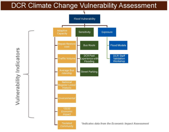
A complete writeup of the methodology and indicators is included in Section 2 and Appendix A of the Final Report that is under review and will be shared under separate cover.
The analysis showed that the most vulnerable parkways in the study area are located near coastal areas as they are impacted by both precipitation based and coastal flooding. In general, the vulnerability across the study area increased from 2030 to 2070, with a total of 112 miles of parkways (59%) with medium or high vulnerability by 2070 as shown in Figure 11 below. Nearly 20% of parkways have a high vulnerability to flooding by the same time period.
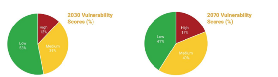
Figure 11. Overall DCR Parkway Vulnerability to Flooding.
The analysis also identified the top 10 most vulnerable parkways to flooding in 2070, as well as hot spots within each of the twenty Focus Areas in the project study area that will help DCR prioritize resources for future adaptation interventions.
| Parkway Name | 2070 Average Vulnerability Score | Rank | Focus Area |
|---|---|---|---|
| Nantasket Avenue | 3.1 | 1 | 18 |
| Winthrop Shore Drive | 3.0 | 2 | 1 |
| Lynnway | 3.0 | 3 | 1 |
| Ocean Avenue | 3.0 | 4 | 1 |
| Nahant Circle / Nahant Road | 2.9 / 2.6 | 5 | 1 |
| Hull Shore Drive | 2.8 | 6 | 18 |
| Broad Sound Avenue / Winthrop Parkway | 2.7 / 2.6 | 7 | 1 |
| Revere Beach Boulevard | 2.7 | 8 | 1 |
| Sozio Rotary, Alewife Brook-Concord Ave Rotary, and Concord Avenue | 2.6 | 9 | 20 |
| William T Morrissey Boulevard | 2.6 | 10 | 19 |
The “Top 10” designation is based on the 2070 average vulnerability scores. Shorter parkways are more likely to have a higher average vulnerability, so parkways less than 0.5 miles were screened out for this top ten list. Additionally, parkways adjacent to one another with similar vulnerability scores were grouped into the same ranking.
As part of the Economic Impact Assessment, eight isolated communities (towns) were determined based on the flooding scenarios where a flooded Parkway is the only transportation route into and out of these eight areas. A flooded Parkway that creates an isolated community has a greater disruption to the transportation network and cascading economic impacts to these communities and the people living and working there.
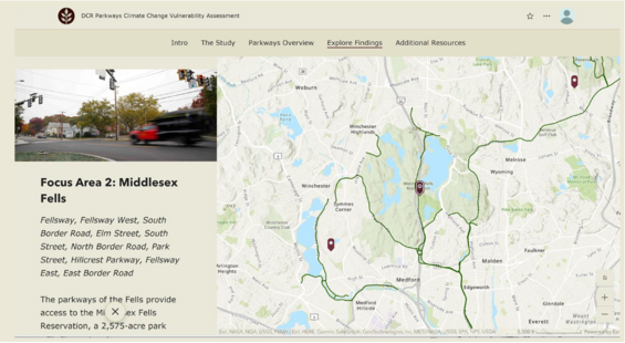
A StoryMap documenting the main study takeaways is under development. It will include a project overview section, methods, and main findings for each Focus Area. DCR will host a public meeting to update stakeholders of project outcomes and share this tool. Please see screenshot below to get an idea of what this resource will look like. A link to the final deliverable will be shared after internal review is completed.
Contributions to 2023 ResilientMass Plan
The Parkways CCVA addresses 2023 ResilientMass Plan and 2022 MA Climate Assessment Priority Impact: Damage to Roads and Loss of Road Service in the Infrastructure Sector, particularly Action 13: Complete climate change vulnerability assessment of DCR’s parkways system to support the DCR Parkways Master Plan. This project advances assessment, research, analysis, science, and mapping necessary to gain understanding of the level of vulnerability of our parkways system and the locations where interventions are most urgently needed to help prioritize spending and decision making.
The project also aligns with the following 2023 ResilientMass Plan goals:
- Science-based and Informed Decision-Making
- Implement Adaptation Actions for Communities and Ecosystems
- Climate mitigation
- Resilient and Equitable Infrastructure, Ecosystems, and Communities