Project Images - Final Condition

Image 1: Roundabout at Oxbow Road (looking west), October 2025

Image 2: Glenmere Road and Bay Path Road intersection at Route 20 (looking west), October 2025

Image 3: Route 20, west of the Route 20 and Route 12 intersection (looking west), October 2025

Image 4: Richardson Corner Road intersection at Route 20 (looking west), October 2025

Image 5: Route 56 intersection at Route 20 (looking west), October 2025

Image 6: Route 12 intersection at Route 20 (looking west), October 2025
Project Images - Construction
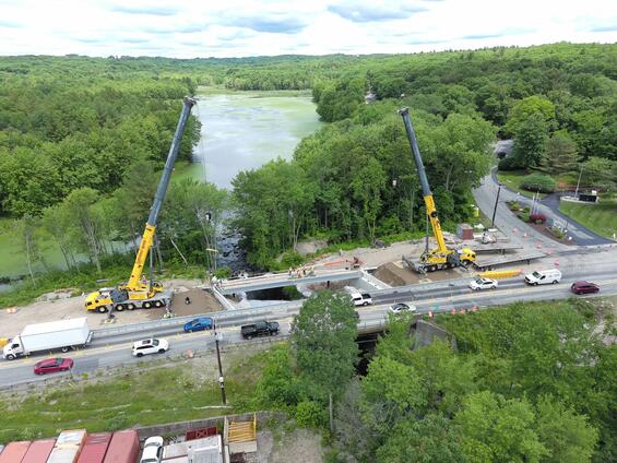
Image 7: Final preparations for a Pre-Fabricated Bridge Unit (PBU) into its permanent location at the French River Bridge in Oxford, MA
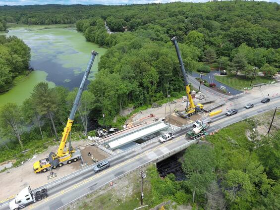
Image 8: Tandem cranes lifting a PBU over a traffic barrier and into its final position at the French River Bridge in Oxford, MA
Project Images - Design
The following proposed improvements and design elements are identified on each plan. The purpose of each element is explained in the legend as they relate to safety improvements, vehicular speed and other roadway updates:
- Intersection Improvements
- Intersection improvements at existing signals to include U-turn bulbs
- Allow drivers to make a U-turn at designated intersections
- Designated right and left turn lanes
- Pedestrian crossings
- Signalized intersections
- Improved operations
- Protected left turn provisions
- Intersection improvements at existing signals to include U-turn bulbs
- Raised median or barrier
- Reduce the severity of crashes
- Reduce the number of crashes
- Emergency pull off areas
- Designated areas for vehicles to safely pull over out of the roadway
- Provides areas for traffic enforcement
- Speed feedback signs
- Inform driver of vehicular speed
- Reinforce the posted speed limit
- Advisory speed signs
- Advise the driver that conditions ahead (curve) warrants a lower vehicular speed
- Lit chevron signs
- Alert drivers to roadway curves ahead
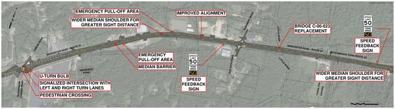
Image 9: Richardson Corner/Oxbow Road in Charlton, MA east to Oak Drive in Oxford, MA
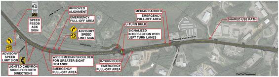
Image 10: Oak Drive to 550 feet west of Route 56 in Oxford, MA. This preliminary concept plan has been updated to replace the traffic signal at Oxbow Road with a roundabout, see Image 4 for the updated design.
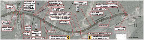
Image 11: Route 56 to Route 12 Intersection in Oxford, MA