Rumney Marshes ACEC Designation Document
Rumney Marshes ACEC Salt Marsh Restoration Plan
Approximate Acreage: 2800 acres
Watershed(s): North Coastal and Boston Harbor (Mystic)
Municipalities: Boston, Lynn, Revere, Saugus, and Winthrop
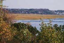
The Rumney Marshes ACEC has been characterized by the U.S. Fish and Wildlife Service as "one of the most biologically significant estuaries in Massachusetts north of Boston." The area includes approximately 1000 acres of highly productive saltmarsh, tidal flats, and shallow subtidal channels. The Belle Isle Marsh area is composed of 275 acres of salt marsh, salt meadow, and tidal flats. All of the Belle Isle Marsh and much of the Rumney Marsh are publicly owned by the Department of Conservation and Recreation or by the municipalities.
An extraordinary variety of birds use the area, and at least five species state-listed as endangered, threatened, or of special concern are recorded there. The saltmarshes are also vitally important to the surrounding human population in their capacity to prevent flood damage by providing flood water storage.
Water Bodies included (partially or entirely) in the ACEC
- Harbors, Sounds, Bays: none
- Rivers: Pines River (Revere, Saugus); Saugus River (Lynn, Revere, Saugus)
- Lakes, Ponds: none
- Brooks, Creeks: Bear Creek (Saugus); Belle Isle Creek (Boston, Winthrop); Diamond Creek (Revere); Sales Creek (Revere)
- Barrier Beaches included in ACEC: none
Maps
Rumney Marshes ACEC - Index Map
Maps are intended to be used with the written boundary description contained in the ACEC designation document. The mapped boundary is not to be used by itself for definitive ACEC boundary delineation or regulatory interpretation. For review of site-specific projects in or bordering the ACEC, determinations must be made in the field by a certified professional in consultation with the appropriate Conservation Commission(s) and ACEC Program Staff.