Overview
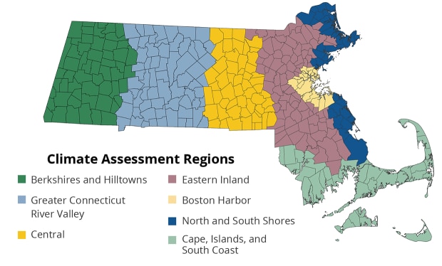
The Commonwealth is already experiencing climate change impacts. Region-specific priorities reflect the unique hazards, natural and built environments, and demographics of each part of the Commonwealth. The Climate Assessment evaluated risks across seven regions:
- Berkshires and Hilltowns Region
- Greater Connecticut River Valley Region
- Central Region
- Eastern Inland Region
- Boston Harbor Region
- North and South Shores Region
- Cape, Islands, and South Coast Region
Volume III of the Climate Assessment includes a summary and full report on each region.
Share These Findings
Share findings about the Eastern Inland region from the MA Climate Change Assessment with your community through the example social media content below:
Regional Context
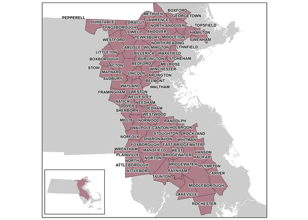
The Eastern Inland region’s 2.1 million people represent more than 30 percent of the state’s population. The region has a relatively low proportion (22 percent) of the state’s environmental justice block groups as designated by EEA. Because of its size, population, and proximity to the Greater Boston area, the region’s network of transportation infrastructure is extensive, with more than 27 percent of the state’s road mileage and 76 percent of the state’s rail mileage. Many residents make use of this transportation infrastructure to commute to neighboring cities and coastal areas for work, but the region also has a growing economy and features the largest number of commercial properties in the state.
The Eastern Inland region boundary used for this assessment overlaps the inland areas of the Municipal Vulnerability Preparedness (MVP) program’s Northeast, Greater Boston, and Southeast regions. Nearly all municipalities in the region are actively engaged in climate resilience planning and adaptation action through the MVP program.
The most important climate hazards for this region include changes to temperature extremes, changes in precipitation patterns, and consequent changes in the patterns of river flows that can lead to inland flooding. Fewer cold winter days could also increase the likelihood that more of the ticks which cause Lyme disease can successfully overwinter, increasing the chance of interactions with population of the Eastern Inland region.
Most Urgent Impacts - Human Sector
The largest region by population, with over 2 million residents, the Eastern Inland region is projected to experience large effects of climate change in the Human Sector. The most urgent impact is the Increase in Vector Borne Diseases Incidence and Bacterial Infections, which is projected to have an extreme magnitude of consequence and disproportionate exposure. One of the largest food distribution centers in Massachusetts is located in Everett and supplies consumers in the Eastern Inland region; it also sits in the 100-year floodplain of the Mystic River, where it may be vulnerable to flooding, potentially leading to interruption of food supply chains. This risk, combined with potentially lower agricultural production in the Commonwealth and beyond, and risks of spoilage and contamination due to power outages and high heat, makes this an urgent impact with disproportionate exposure.
Most Urgent Impacts - Infrastructure Sector
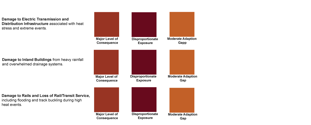
The priority impacts in the Eastern Inland region match those in the statewide assessment, primarily due to the large inventory of infrastructure in this region. Damage to Electric Transmission and Utility Distribution Infrastructure, from stressors such as extreme temperature, extreme rain, lightning, vegetation growth, wildfire activity, and coastal flooding in this region are considered extreme and are the highest among regions in the Commonwealth. The region also has a high risk for Damage to Inland Buildings when measured as a percentage of the total structure value in the region. The region is expected to experience the largest absolute annual economic impact of inland flooding in the Commonwealth by 2050 ($27 million annually). Finally, Damage to Rails and Loss of Rail/Transit Service is an important impact category in the region, particularly because of the role rail (both commuter line and the subway, or the “T”) play in connecting the region to Boston and the hub of economic activity. The cost of repairing tracks due to damage incurred as a result of extreme heat deforming rails for the Eastern Inland portion of commuter and freight rail lines are the largest among regions in the state.
*Due to tied scores in the urgency rankings, the Infrastructure sector has three most urgent impacts for this region.
Read more about infrastructure sector impacts in the report.
Most Urgent Impacts - Natural Environment Sector
Open space and natural environments in the region, particularly freshwater and forest habitats, are expected to face increased pressure from the stressors of climate change. Many of the freshwater resources in the region are currently listed on the states Impaired Waters list for waterbodies not meeting surface water quality standards. Intense precipitation events scour and erode stream channels, and increase nutrient and contaminant concentrations in freshwater bodies. This effect is magnified in watersheds with high levels of impervious surface coverage. The region is also home to over one million acres of forest. Climate change is expected to reduce the flow of ecosystem services from forests through changing composition (as species ranges shift with changing temperatures), increased pests, and more tree mortality during extreme storms.
Read more about natural environment sector impacts in the report.
Most Urgent Impacts - Governance Sector
The region could face significant costs as receivers of climate migrants from other areas of the Commonwealth (particularly from areas at risk of sea level rise) and beyond. Within Massachusetts, this outcome may be observed as movement from coastal regions of Massachusetts to nearby but inland regions, such as the medium-sized urban or suburban areas of the Eastern Inland region, which also maintain commuting access to the largest job centers in the state in the Boston Harbor region. The costs of climate migration could include specialized housing provision, both short-term and medium-term; social services; increased educational costs to school systems; and pressure on existing public infrastructure. Increase in Demand for State and Municipal Government Services is another impact with projected major consequences, with the potential for disproportionate exposure. For this region there could be increased needs for MassHealth, food security support, and emergency response as a result of climate change.
Most Urgent Impacts - Economy Sector
The most urgent impacts for the region in the Economy sector are the Reduced Ability to Work and the Reduction in the Availability of Affordably Priced Housing. Eastern Inland region workers in high-risk industries are projected to lose 34 hours per worker each year by 2050 and 127 hours per worker each year by 2090, nearly the highest in the Commonwealth by the end of the century. The high projected incidence of air pollution morbidity, vector-borne disease morbidity, and heat-related occupational inability to work combine uniquely in this region to make it most vulnerable to a reduced ability to work. Climate change could affect the availability of affordably priced housing in multiple ways, including through coastal and inland flood risks which can directly or indirectly affect both publicly owned housing and the market for affordably priced housing. The current need for affordably priced housing in the Eastern Inland region is exacerbated by relatively high housing prices overall in many parts of this region.
Featured Adaptation Effort
Traphole Brook Flood Prevention and Stream Restoration Project
The Town of Norwood partnered with the Neponset River Watershed Association to remove the Mill Pond Dam, which was at risk of failure during the kind of major storm events that are increasing due to climate change. Restoring the natural flow of the brook significantly reduces flood risk for abutters and improves aquatic habitat conditions.
Quick links
- ResilientMass Homepage
- ResilientMass Site Map
- Massachusetts Climate Change Assessment
- Massachusetts Climate Change Assessment – Berkshires and Hilltowns Region
- Massachusetts Climate Change Assessment – Greater Connecticut River Valley Region
- Massachusetts Climate Change Assessment – Central Region
- Massachusetts Climate Change Assessment – Boston Harbor Region
- Massachusetts Climate Change Assessment – North and South Shores Region
- Massachusetts Climate Change Assessment – Cape, Islands, and South Coast Region
- Massachusetts Climate Change Assessment – Regional Summary Volume III
- Massachusetts Climate Change Assessment – Regional Report Volume III


