Overview
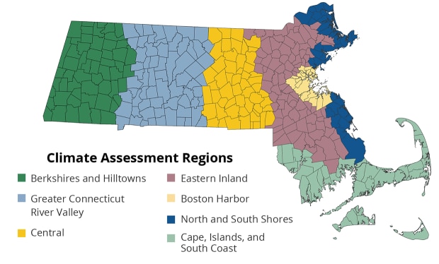
The Commonwealth is already experiencing climate change impacts. Region-specific priorities reflect the unique hazards, natural and built environments, and demographics of each part of the Commonwealth. The Climate Assessment evaluated risks across seven regions:
- Berkshires and Hilltowns Region
- Greater Connecticut River Valley Region
- Central Region
- Eastern Inland Region
- Boston Harbor Region
- North and South Shores Region
- Cape, Islands, and South Coast Region
Volume III of the Climate Assessment includes a summary and full report on each region.
Share These Findings
Share findings about the North and South Shores region from the MA Climate Change Assessment with your community through the example social media content below:
Regional Context
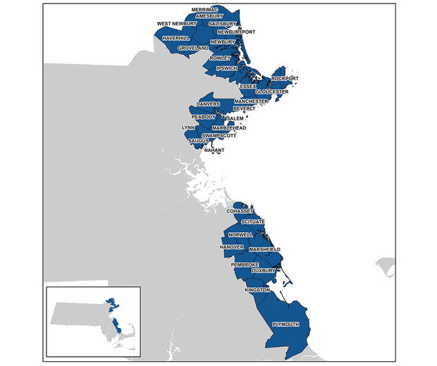
The North and South Shores region includes 32 coastal municipalities flanking the Greater Boston area. The two areas north and south of Boston are grouped together in this region because, although they each have distinct characteristics, the hazards faced and populations and resources exposed are similar. Around ten percent of the state population live in the region, which is made up of mostly mid-sized cities and towns. In total, the region has less than seven percent of the state’s environmental justice block groups. The blue economy (meaning economic activity around sustainable ocean resources use) plays a growing role in the region, though the main economic drivers continue to be healthcare, professional services, manufacturing, and finance.
The North and South Shores have more coastal wetland area than any other region, with nearly 24,000 acres of high and low marsh, and the region also features more than 38 miles of marine beach. These coastal areas and the marine ecosystems off the coast are key resources in the region, stimulating the regional economy, providing local food sources, protecting coastal people and infrastructure, and carrying significant cultural value. As of the FY2023 Municipal Vulnerability Preparedness (MVP) grant round, all the region’s municipalities are actively engaged in climate resilience planning and adaptation action through the MVP program.
The most important climate hazards for this region include changes to coastal hazards, including sea surface temperature changes, coastal flooding, and the potential for hurricane force winds from both tropical and extratropical storms; and flooding associated with high rainfall events. Coastal hazards can affect built infrastructure, marine fisheries productivity, emergency service response times and evacuation routes, and the incidence of injuries.
Most Urgent Impacts - Human Sector
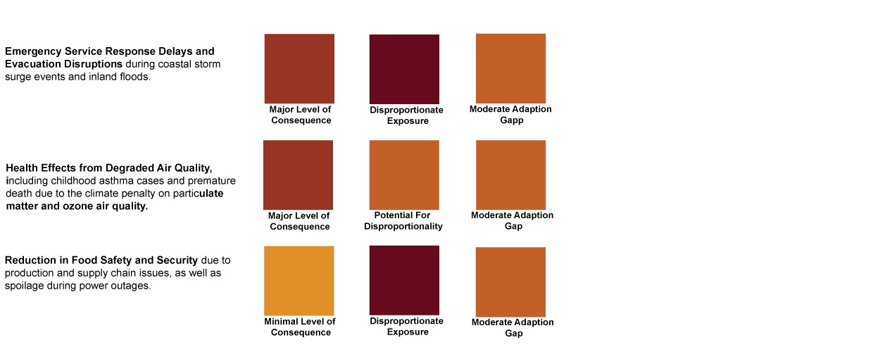
The North and South Shores regions are most at risk of Human sector impacts related to sea level rise flooding and the air quality effects of climate change. Over the next century, climate change is expected to increase coastal traffic delays due to roads becoming impassable during storm events due to the combined effects of sea level rise and storm surge events, which can lead to emergency service delays and evacuation disruptions. This issue is particularly concerning in areas of the North and South Shore region reliant on limited evacuation routes. Food distribution centers and transportation routes are particularly vulnerable to coastal flooding, and supply chain issues can result in unavailability of food. Food safety, particularly associated with spoilage and bacterial contamination, is also associated with high temperature events and risk of power outages. Air quality degradation is also a highly urgent impact in this region. Climate change worsens air quality via warmer temperatures increasing the rate of ground-level ozone formation, less frequent rain events reducing flushing of particulate matter, and increasing wildfire, both in Massachusetts and across North America.
*Due to tied scores in the urgency rankings, the Human sector has three most urgent impacts for this region.
Read more about human sector impacts in the report.
Most Urgent Impacts - Infrastructure Sector
The most urgent impacts in the Infrastructure sector in the North and South Shores region are primarily driven by coastal flooding and storms. This region has the second highest (behind Boston Harbor region) costs of repair for Damage to Electric Transmission and Utility Distribution Infrastructure among regions in the Commonwealth. Available estimates could grow to an additional $8 million in 2030; $13 million annually in 2050; $25 million in 2070; and $37 million annually by 2090. Damage to Coastal Buildings and Ports is the second most urgent impact. Current damages in this region from coastal floods on residential, commercial, and industrial properties are $25 million per year and are projected to grow an additional $15 million by 2030; $35 million by 2050; and $75 million by 2070.
Read more about infrastructure sector impacts in the report.
Most Urgent Impacts - Natural Environment Sector
With nearly 40 miles of beaches and nearly 24,000 acres of saltwater marsh, the North and South Shores region is defined by its marine and coastal natural resources. Impacts to marine ecosystems from increased temperatures, ocean acidification, and degradation of nearshore water quality are projected to have an extreme magnitude of consequence and have an extreme adaptation gap. The region is projected to experience near term gains in total salt marsh area (with regularly flooded marsh expanding at a faster rate than the projected loss of irregularly flooded marsh), though by the end of the century, the rate of irregularly flooded marsh loss accelerates, resulting in a net loss of about 63 percent of saltmarsh in the region by 2100. These impacts are foundational to many other impacts and sectors in the region including human health and wellbeing and economic activity.
Read more about natural environment sector impacts in the report.
Most Urgent Impacts - Governance Sector
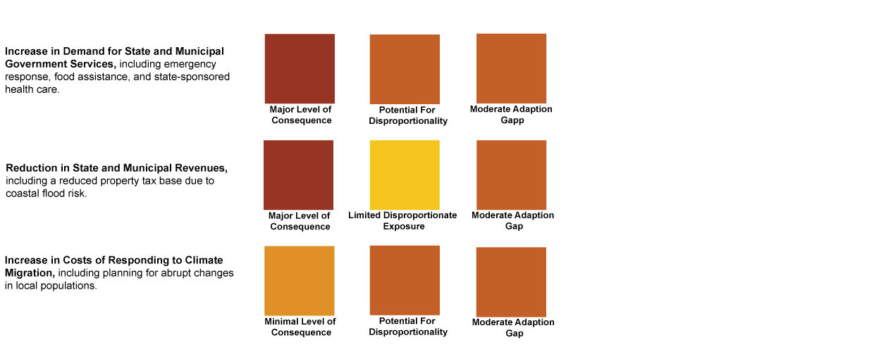
As noted in the Human and Infrastructure sector descriptions above, in the North and South Shores region there could be increased needs for statewide health services, food security support, and emergency response as a result of climate change particularly connected to impassable road during extreme coastal storm events or more routine “high-tide” or “sunny-day” flooding of critical road infrastructure. In addition, many of these impacts can be expected to be concentrated among those residing in low-income block groups. At the same time, state and municipal revenues could be reduced, primarily through decreases in property values and therefore property tax revenue, but also tax losses associated with business interruptions. Projected property tax revenue losses statewide top $100 million by mid-century, and although figures are not available specifically for the North and South Shores region, the region could experience a significant portion of those losses given its exposure to coastal hazards.
*Due to tied scores in the urgency rankings, the Governance sector has three most urgent impacts for this region.
Read more about governance sector impacts in the report.
Most Urgent Impacts - Economy Sector
Climate change is projected to affect the economy in this region primarily through a Reduction in the Availability of Affordably Priced Housing availability and a Reduced Ability to Work due to high heat days and commute delays. All of the most urgent impacts in this sector are expected to disproportionately affect people living in EJ block groups. The current need for affordably priced housing in the North and South Shores region is exacerbated by relatively high housing prices overall in many parts of this region. Workers in the region are projected to experience a loss in ability to work through road delays driven by high tide flooding, commuter rail (an important connection from the region to the economic activity in Boston) delays due to track buckling on high heat days, and reduction in hours for high-risk workers (i.e., those exposed to outdoor weather) during extreme heat.
Featured Adaptation Effort
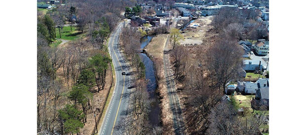
Peabody-Salem Resilient North River Corridor & Riverwalk Project
In Peabody and Salem, the North River Canal restoration project has installed and will continue to install elevated river walkways, rain gardens, and other recreational amenities. This work will improve flood resilience along this tidal river.
Quick links
- ResilientMass Homepage
- ResilientMass Site Map
- Massachusetts Climate Change Assessment
- Massachusetts Climate Change Assessment – Berkshires and Hilltowns Region
- Massachusetts Climate Change Assessment – Greater Connecticut River Valley Region
- Massachusetts Climate Change Assessment – Central Region
- Massachusetts Climate Change Assessment – Eastern Inland Region
- Massachusetts Climate Change Assessment – Boston Harbor Region
- Massachusetts Climate Change Assessment – Cape, Islands, and South Coast Region
- Massachusetts Climate Change Assessment – Regional Summary Volume III
- Massachusetts Climate Change Assessment – Regional Report Volume III
