Location listing filters
Map for Erving State Forest
Note for screen reader users, we suggest skip the following interactive map and go to the location listing for a better user experience.
Currently, the map is not accessible yet for a comprehensive experience.
skip to the location listing
Location Listing
Showing 1 - 4 of 4 results for Other locations related to Erving State Forest
-
Federated Women's Club State Forest
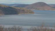
State Forest Road, Petersham, MA 01366 DirectionsExplore more than 1,000 acres of pine, maple, birch, and hemlock trees. Make your way along Fever Brook for great views of the Quabbin Reservoir. Other popular activities include fishing, hunting, and camping.Phone(978) 544-3939-
Sunrise to sunset
-
-
Lake Wyola State Park
- Wheelchair Accessible
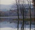
94 Lakeview Road, Shutesbury, MA 01072 DirectionsLake Wyola State Park, also known as the Carroll A. Holmes Recreation Area, is located in the quaint hill town of Shutesbury, just north of Amherst. This day-use area is located on the shores of Lake Wyola, a Native American word meaning “quiet waters.” Swim or fish, or use one of the charcoal grills in the picnic area.Phone(413) 367-0317-
Sunday - Saturday:9:00 am-7:30 pm
-

Mount Grace State Forest
78 Winchester Road, Warwick, MA 01378 DirectionsExplore a network of multi-use trails that traverse this scenic peak. Hike or horseback ride to its 1,621-foot summit, or during winter, break out your snowmobile or skis.Phone(978) 544-3939-
Sunrise to sunset
-
-

Wendell State Forest
- Wheelchair Accessible
392 Wendell Rd, Millers Falls, MA 01349 DirectionsWendell State Forest is 7,566 acres of rolling forested hills, streams, ponds, trails, a baseball diamond, and a picnic area. You can visit Wendell any time of year.Phone(413) 659-3797-
Sunrise to sunset