- Division of Ecological Restoration
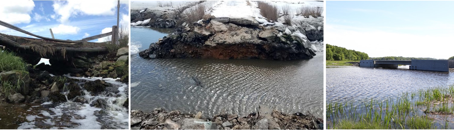
The Kent’s Island Salt Marsh Restoration project is located in Newbury, within the William Forward Wildlife Management Area. This project was completed in 2019 and included the replacement of a small, severely dilapidated bridge over tidal Kent’s Island Creek. With material from the bridge and banks filling in the creek, this structure had created a severe tidal restriction, preventing natural tidal flow. The restriction of tidal flow directly impacted the 47-acre saltmarsh located upstream of the bridge.
Working with MassWildlife and with additional funding from the US Fish and Wildlife Service’s North American Wetlands Conservation Act Grant Program, DER was able to replace this old and crumbling bridge with a new, larger-span structure that allows for natural tidal flow. By restoring the flow to this system, this project reduced flow velocity and associated scour and erosion, improved access for wildlife passage, and through the reconstruction of the bridge, allowed for safe access to the 70 acres of upland grassland and shrubland habitat managed by MassWildlife.
Following the completion of this project, DER staff continue to monitor the site. By collecting data on characteristics such as water level, salinity, and vegetation, DER can gather valuable information about exactly how this work benefits the ecosystem, both to help inform future restoration efforts in other locations as well as to make sure the Kent’s Island site is responding as anticipated.
The tidal monitoring conducted in summer 2021 confirmed that removal of the tidal restriction did restore upstream tidal flow to the salt marsh. Comparing 2008 (pre-restoration) to 2021 (post-restoration) data, we can see evidence of tidal flow restoration. See the graphs below for a visual representation of these data. In 2008, the water was able to flow upstream of the bridge on the incoming tide, but the old bridge caused a restriction that prevented water from fully draining from the upstream tidal creek with the outgoing tide. This is reflected in the tidal data measured in 2008 (see the graph below)—the upstream high water levels (high tide elevations) matched the downstream levels, but the upstream low water levels (low tide elevations) did not match the downstream lows. The 2021 tidal data shows that the upstream water movement is now almost identical to the downstream tidal changes, meaning that the bridge is no longer causing a restriction and is not having an impact on tidal flow. With restored tidal flow, the saltmarsh at this site can now thrive and provide lasting benefits to the system.
DER staff also conducted vegetation monitoring in September 2021 to monitor the post-construction recovery of salt marsh habitat near the bridge that had been temporarily disturbed during construction. Initial monitoring results show that the salt marsh and upland plant species have recolonized the slopes along the sides of the road, and that the majority of bushes planted after construction had survived two years and appeared healthy. DER and partners will continue to monitor these areas over the next few years to track the recovery of salt marsh vegetation.
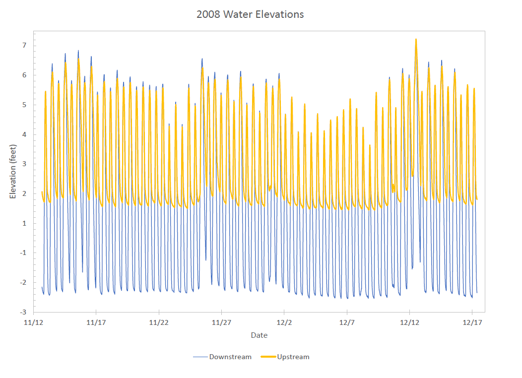
In this graph of data from 2008 (pre-restoration), you can see that the downstream tidal flow exhibited a full range of elevations from high to low tides, while the upstream tidal flow was restricted at low tides.
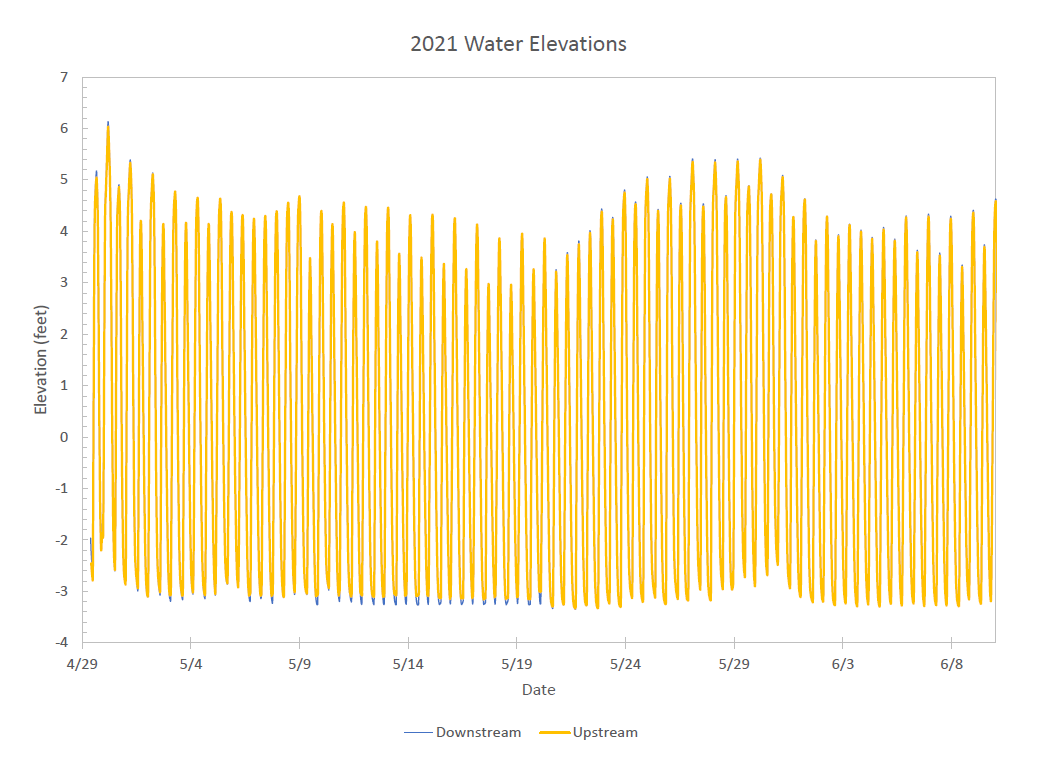
In this graph of data from 2021 (post-restoration), you can see that the upstream tidal range almost completely overlaps the downstream tidal range, meaning that the crossing at the bridge is not having an impact on tidal flow.