- Division of Marine Fisheries
Cox Ledge and the surrounding area of Southern New England waters have been slated for wind energy development starting in 2022. This area supports one of the remaining major spawning components of Atlantic cod. Cod use noise to communicate during the spawning season and an increasing body of literature demonstrates that construction noise and operations can disrupt spawning activity. However, there is relatively little information available to evaluate the habitat use and spawning dynamics of cod in the Cox Ledge region.
In order to provide fine-scale information needed to elucidate the potential overlap between offshore wind development and cod spawning activity in this area, DMF researchers are partnering with colleagues from UMass Dartmouth’s School for Marine Science & Technology, the National Oceanic and Atmospheric Administration, Woods Hole Oceanographic Institution, Rutgers University, and The Nature Conservancy to better understand the distribution and timing of cod spawning near Cox Ledge. The project team received funding from the Bureau of Ocean Energy Management to conduct this research.
The field work, which is just getting underway, will be carried out in collaboration with recreational and commercial fishermen in the region. Acoustic transmitters will be deployed on cod in the vicinity of Cox Ledge during two spawning seasons. The transmitters have an expected battery life of approximately 1600 days, enabling us to investigate multi-year residence and fidelity to the spawning site.
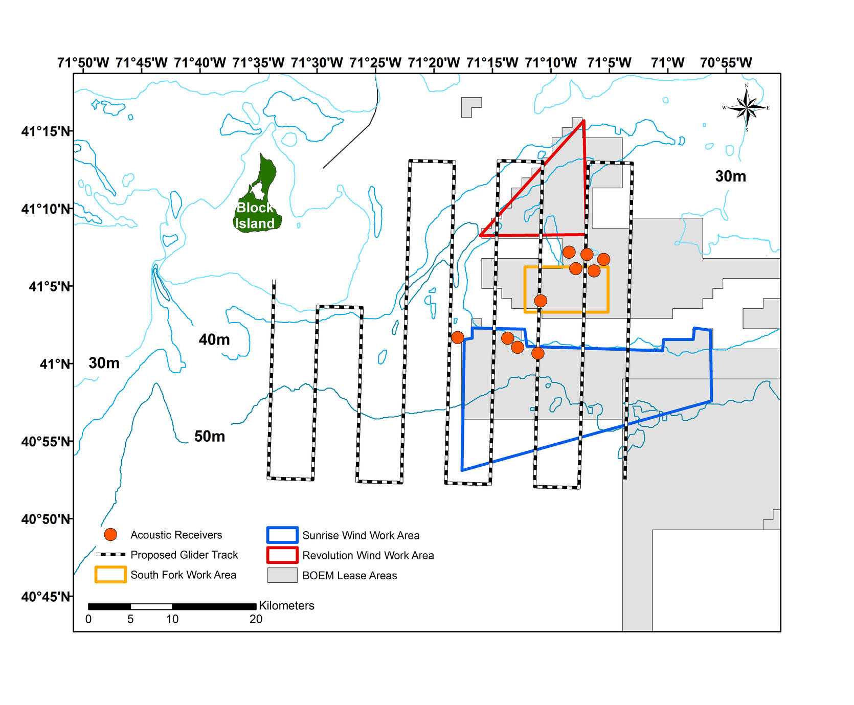
The distribution of cod tagged with acoustic receivers will be monitored over three spawning seasons using an acoustic receiver mounted on an autonomous glider. The glider will follow a pre-programmed route to survey the study area four times during each spawning season. Acoustic receivers moored in strategic locations will also be used to estimate residence, dispersal, thermal preferences, and habitat use of tagged cod. Ten acoustic receivers were deployed in November near Cox Ledge, and the array will be expanded to 25 receivers in 2020.
Conventional tags will be applied to sub-legal cod in order to investigate regional movement patterns from fishery recaptures. In addition, commercial and recreational fisheries will be sampled in southern New England to characterize cod demographics (e.g., sex, reproductive stages, fish length and age) and to inform regional investigations into cod stock structure.
Outcomes from the research will be a characterization of the spawning dynamics and thermal habitats of cod in Southern New England, and assessment of their connectivity with other cod populations. The anticipated benefits include an understanding of seasonal habitat usage to help evaluate the potential impacts of offshore wind development.
By Gregory DeCelles, PhD, Stock Assessment Specialist