Central Nashua River Valley ACEC Designation Document
Watershed(s): Nashua
Municipalities: Bolton, Harvard, Lancaster and Leominster
The Central Nashua River Valley ACEC is approximately 12,900 acres in size and is located in Bolton (700 acres), Harvard (1,850 acres), Lancaster (10,100 acres) and Leominster (250 acres).
The heart of the Central Nashua River Valley ACEC is the 20-mile riparian corridor of the North Nashua and Nashua Rivers situated south of Route 2 in Leominster, Lancaster, Bolton and Harvard. Associated with this corridor are extensive surface waters, wetlands, floodplains and aquifers, as well as interrelated riparian and upland wildlife and rare species habitat, forest, farmlands, and publicly and privately owned open space.
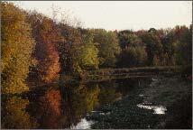
Portions of the ACEC are included in the statewide Scenic Landscape Inventory, and reflect the unique cultural history and natural beauty of this area, with its hills, farmlands and forests gently contrasting with the Nashua River and the adjacent floodplains, streams and wetlands.
An extensive network of publicly and privately owned open space is located within the ACEC. These lands include the Oxbow National Wildlife Refuge, Bolton Flats Wildlife Management Area, and over 1,000 acres of other state, municipal and privately owned conservation and recreation lands. The 4,830 acres of the South Post of Fort Devens provide additional open space resources (not open to the public). The total amount of open space within the ACEC is approximately 7,900 acres, or approximately 61% of the ACEC.
Further, the river valley provides significant linkages between important wildlife areas. At least 19 state-listed rare species occur within the ACEC. These figures do not include several federal or state-listed rare bird species that are known to utilize the area, but are not listed on the State's rare species database because they are not known to breed within the area. Rare species habitats cover approximately 4,975 acres, or 39% of the ACEC. The wetlands and tributaries are federally listed as priority wetlands, due to their importance to the Atlantic Flyway for migrating birds.
Water bodies included (partially or entirely) in the ACEC
- Rivers: North Nashua River (Lancaster, Leominster), Nashua River, (Bolton, Harvard, Lancaster), Still River (Bolton, Harvard), Dead River (Bolton, Harvard)
- Lakes, Ponds: Little Spectacle, Spectacle, Oak Hill, Slate Rock, Cranberry Ponds (Lancaster), several unnamed ponds, especially numerous oxbow ponds along the Nashua River
- Brooks, Creeks: Fall Brook (Leominster); McGovern, Spectacle, Ponakin, Slate Rock and Cranberry Brooks (Lancaster); several unnamed streams and brooks throughout the area
Maps
Central Nashua River Valley ACEC - Index Map
Central Nashua River Valley ACEC Map 4a
Central Nashua River Valley ACEC Map 4b
Central Nashua River Valley ACEC Map 4c
Central Nashua River Valley ACEC Map 4d
Central Nashua River Valley ACEC Map 4e
Central Nashua River Valley ACEC Map 4f
Central Nashua River Valley ACEC Map 4g
Central Nashua River Valley ACEC Map 4h
Central Nashua River Valley ACEC Map 4i
Central Nashua River Valley ACEC Map 4j
Maps are intended to be used with the written boundary description contained in the ACEC designation document. The mapped boundary is not to be used by itself for definitive ACEC boundary delineation or regulatory interpretation. For review of site-specific projects in or bordering the ACEC, determinations must be made in the field by a certified professional in consultation with the appropriate Conservation Commission(s) and ACEC Program Staff.