Water column mapping is the process of modeling and mapping physical water column parameters, such as temperature, current velocity, and salinity. Since 2010, CZM has been collecting benthic samples (sediment samples sieved to reveal the small, sediment-dwelling animals) and seafloor imagery to map the distribution, and in some instances the abundance and relationships, of flora and fauna in Massachusetts marine waters. This work is important to marine spatial planning activities ranging from identifying and classifying habitats to siting new ocean uses such as renewable energy.
Approach
In 2011, CZM recognized that a better understanding of the water column—the name oceanographers give to the region between the seafloor and the sea surface—would support its ocean planning efforts. Starting in 2011, CZM led a working group to oversee a University of Massachusetts-Dartmouth School for Marine Science and Technology (SMAST) project sponsored, in part, by SeaPlan to map specific features of the water column, including temperature, salinity, and currents.
SMAST used a powerful oceanographic model to create a hindcast (a projection of past events, as opposed to a forecast, which is a projection of future events) of surface and bottom temperature, salinity, stratification, and current velocity for 1978-2013. The Finite-Volume Community Ocean Model (PDF, 3 MB) (FVCOM) produces hourly estimates that can be binned to desired timescales (e.g., monthly, seasonally, annually). This work was overseen by an advisory committee composed of members from CZM, the U.S. Geological Survey (USGS), National Oceanic and Atmospheric Administration (NOAA), and the Woods Hole Oceanographic Institution (WHOI).
These data will be used to look for patterns and to help explain the observed distribution of sediments and/or biota in Massachusetts waters over time. For example, CZM and USGS are planning to develop maps that describe the frequency of disturbance of the Massachusetts seafloor using current velocity data combined with seafloor sediment type. These maps will help CZM and others evaluate the stability of various habitats, which can help determine what areas may be important to re-visit more frequently for mapping or characterization work and may help inform the review and siting of ocean projects. Likewise, water column data can be combined with bathymetry and sediment type to map potential habitat.
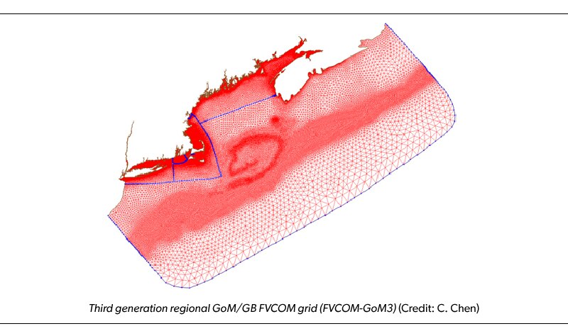
A map of the marine and coastal waters over which the UMass-Dartmouth School for Marine Science and Technology’s Finite-Volume Community Ocean Model produces hydrographic data for CZM. The model domain extends from New Jersey to Nova Scotia. Each red triangle is one cell in the model. The model has coarser resolution (i.e., larger triangles) farther from shore and much finer resolution along the shoreline and in embayments.