Ellisville Harbor ACEC Designation Document
Approximate Acreage: 600 acres
Watershed(s): South Coastal
Municipalities: Plymouth
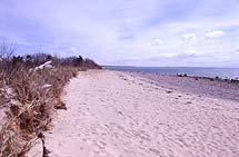
The Ellisville Harbor ACEC comprises approximately 600 acres of widely diverse habitats and vegetation including a sheltered harbor, sandy beaches, salt marsh, steep bluffs, kettle holes, a small sphagnum bog, and scenic, rural upland sites with woodland and meadow. Its ponds and marshes are feeding and breeding grounds for many aquatic birds, and the salt marsh supports shellfish and finfish. The barrier beach system, dunes, and salt marshes provide storm protection for the low-lying inland areas.
Archaeological records indicate at least two Native American sites within the ACEC. The open areas are a vestige of the extensive farmlands that once characterized the Massachusetts coast. The maintenance of high water quality, vulnerable because of the high water table, is important to the public health for water supply, and for shellfishing, fishing, and recreation.
The scenic qualities of the ACEC include both seaward and landward vistas of lobster boats in the harbor, Cape Cod in the distance, and upland farmland a unique feature within an hour's drive of Boston. Situated along the western shore of Cape Cod Bay, just five miles north of the Cape Cod Canal, the ACEC borders the Cape Cod Bay Ocean Sanctuary.
In 1991, DCR acquired nearly 100 acres at the heart of the ACEC, as the Ellisville Harbor State Park. A Master Plan was developed for the state park in 1993. Protection of resources is the first priority for management and only low-impact passive recreation is encouraged. The park offers outstanding scenic qualities through forested uplands, salt marsh, and beach access.
Water Bodies included (partially or entirely) in the ACEC
- Harbors, Sounds, Bays: Ellisville Harbor
- Rivers: none
- Lakes, Ponds: Black Pond, Center Hill Pond
- Brooks, Creeks: unnamed
- Barrier Beaches included in ACEC: beaches flanking harbor mouth (Pm-12), areas fronting Black Pond (Pm-11), and Center Hill Pond (Pm-10)
Maps
Ellisville Harbor ACEC - Index Map
Maps are intended to be used with the written boundary description contained in the ACEC designation document. The mapped boundary is not to be used by itself for definitive ACEC boundary delineation or regulatory interpretation. For review of site-specific projects in or bordering the ACEC, determinations must be made in the field by a certified professional in consultation with the appropriate Conservation Commission(s) and ACEC Program Staff.