Hinsdale Flats Watershed ACEC Designation Document
Approximate Acreage: 14,500 acres
Watershed(s): Housatonic and Westfield
Municipalities: Dalton, Hinsdale, Peru, and Washington
The Hinsdale Flats Watershed ACEC covers approximately 14,500 acres and is located at the headwaters of the East Branch of the Housatonic River in four communities in central Berkshire County. The ACEC is generally defined by several watershed subbasins that contribute to the northward-flowing headwaters of the East Branch of the Housatonic above the Old Grist Mill Dam in the town of Hinsdale.
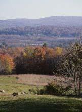
Beginning in the town of Washington, the East Branch flows through extensive wetlands and floodplains known as the Hinsdale Flats. Tributary streams flow into the Flats and East Branch from higher elevations and ridges to the east, west, and south. The Appalachian National Scenic Trail forms the western boundary of the ACEC. The unique topography and contrasting land forms provide scenic vistas of the lowlands of the Flats and the predominantly wooded uplands that surround it. Open fields and farmlands, extensive forestlands, and historic and archaeological resources are integral parts of the ACEC.
The excellent water quality of the East Branch and its tributaries, the wetlands and floodplains of the Hinsdale Flats, and the surrounding uplands support an outstanding variety of natural communities and wildlife, including six state-listed rare species. Several summer camps, vacation homes, and public recreation areas (including the Hinsdale Flats Wildlife Management Area, Ashmere Lake, and Plunket Reservoir) benefit from the natural beauty and resources of the area. Surface and ground water provide drinking water for residents of the area, and the headwaters contribute to important water supplies downstream. The unique environmental qualities of the area are important to the entire Berkshire region.
Water Bodies included (partially or entirely) in the ACEC
- Rivers: East Branch of Housatonic (Hinsdale, Washington)
- Lakes, Ponds: Ashmere Lake; Belmont, Fernwood, and Plunkett Reservoirs, Muddy Pond (Hinsdale); Tracy Pond (Peru); Muddy Pond (Washington)
- Brooks, Creeks: Bennett, Bilodeau, Cady (both), Frisell, Russo, Tracy, and Welch Brooks (Hinsdale); Bilodeau, Kilburn, and Tracy Brooks (Peru); Depot Brook (Washington)
Maps
Hinsdale Flats Watershed ACEC - Index Map
Hinsdale Flats Watershed ACEC Map 11a
Hinsdale Flats Watershed ACEC Map 11b
Hinsdale Flats Watershed ACEC Map 11c
Hinsdale Flats Watershed ACEC Map 11d
Hinsdale Flats Watershed ACEC Map 11e
Hinsdale Flats Watershed ACEC Map 11f
Hinsdale Flats Watershed ACEC Map 11g
Maps are intended to be used with the written boundary description contained in the ACEC designation document. The mapped boundary is not to be used by itself for definitive ACEC boundary delineation or regulatory interpretation. For review of site-specific projects in or bordering the ACEC, determinations must be made in the field by a certified professional in consultation with the appropriate Conservation Commission(s) and ACEC Program Staff.