Hockomock Swamp ACEC Designation Document
Approximate Acreage: 16,950 acres
Watershed(s): Taunton
Municipalities: Bridgewater, Easton, Norton, Raynham, Taunton, and West Bridgewater
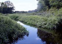
The Hockomock Swamp and associated wetlands and water bodies comprise the largest vegetated freshwater wetland system in Massachusetts. The boundaries of the Hockomock Swamp ACEC include approximately 16,950 acres in the southeastern part of the state. The wetlands act as a huge water reservoir and serve as the headwaters for the Town River, which flows into the Taunton River. The wetlands and floodplains are connected hydrologically with an extensive underlying system of medium- and high-yield aquifers. There are three public water supply wells located in the ACEC, and others are proposed.
The Hockomock Swamp is a vast natural and scenic area. Because of its size, it is a unique and irreplaceable wildlife habitat. It is also the location of at least 13 rare and endangered species. According to the Massachusetts Historical Commission, the archaeological sites in the vicinity of this wetland complex are known to span a period of 9000 years; the potential quality and significance of the archaeological resources are enormous. Productive agricultural lands are located on the uplands adjacent to the wetlands, brooks, and rivers.
The Division of Fisheries and Wildlife (DFW) owns approximately 5000 acres of the Hockomock Swamp, within all six communities. The Hockomock Swamp Wildlife Management Area provides public access to the swamp and to several recreational areas. Additional public and nonprofit lands are located within the ACEC. The area is popular for hunting, fishing, boating, canoeing, swimming, and for the observation and study of flora and fauna.
Water Bodies included (partially or entirely) in the ACEC
- Rivers: Hockomock River (Bridgewater, West Bridgewater); Snake River (Norton, Taunton); Town River (Bridgewater, West Bridgewater)
- Lakes, Ponds: Gushee Pond (Raynham); Hewitts Pond (Raynham); Lake Nippenicket (Bridgewater, Raynham); Nunkets Pond (Bridgewater, Raynham)
- Wetlands: Hockomock Swamp (Bridgewater, Easton, Norton, Raynham, Taunton, West Bridgewater); Dead Swamp (Raynham); Titicut Swamp (Bridgewater, Raynham); Little Cedar Swamp (Easton)
- Brooks, Creeks: Black Brook (Easton); Coweesset Brook, West Meadow Brook, Onemile Brook (West Bridgewater)
Maps
Hockomock Swamp ACEC - Index Map
Maps are intended to be used with the written boundary description contained in the ACEC designation document. The mapped boundary is not to be used by itself for definitive ACEC boundary delineation or regulatory interpretation. For review of site-specific projects in or bordering the ACEC, determinations must be made in the field by a certified professional in consultation with the appropriate Conservation Commission(s) and ACEC Program Staff.