BUAR classifies certain shipwrecks and other underwater archaeological resources as "Exempted Sites" for a variety of reasons, including (but not limited to): commonly known location, previous salvage, recreational value, educational value, or lack of significant archaeological or historical value. Recreational diving activities on these sites, including casual artifact collection, do not require a BUAR permit. However, any major disruption of the site is prohibited. The intent of creating an exempted shipwreck site is to preserve such sites for the continued enjoyment of the recreational diving community, who is encouraged to protect these sites for the continued enjoyment of all.
Note: All dives are conducted at your own risk. The Commonwealth of Massachusetts accepts no responsibility for loss of any kind, including personal injury or property damage. The Commonwealth of Massachusetts assumes no liability for inaccuracies in dive information contained in these pages including site locations and dive conditions.
Vessel Details
Description: Liberty Ship, steel.
Dimensions: length 417.7 ft., width 56.9 ft., depth 37.3 ft.
Tonnage: gross 7176, other displacement - 14245.
Propulsion: steam, single propeller.
Machinery: (1) 3 cylinder, triple expansion, Filer & Stowell Co. engine, indicated horsepower 2,500, cylinder diameters 24.5", 37", 70" with a stroke of 48"; (2) Combustion Engineering Co. Inc., oil fired, water tube boilers; solid bronze propeller; tail shaft fitted with a continuous liner.
The Shipwreck
Date Sunk: 1950.
Cause: grounded.
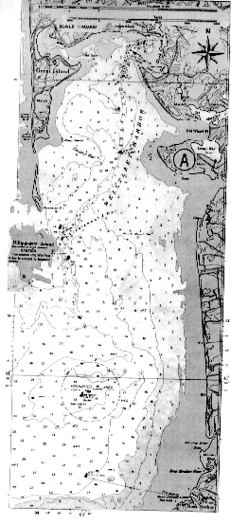
Location: Cape Cod Bay, off Eastham, inside of Billingsgate Shoal.
Coordinates: latitude 41° 49.7' N; longitude 70° 03.0' W.
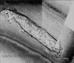
On October 26, 1943, gale force winds pushed the "Liberty Ship" James Longstreet onto the flats of Sandy Hook, New Jersey. It grounded on the flood tide so when the storm abated and the tide fell the steamer was high and dry. Badly damaged, the vessel wasn't refloated until November 23rd. Towed to New York for further repairs, it was found to be structurally unfit for sea. The Navy used her as a test ship until it was towed to Cape Cod Bay for use as a target. By 1973 when William Quinn wrote Shipwrecks Around Cape Cod, the steamer's remains were riddled with holes from bullets to bombs. It was likened to a "steel plated Swiss cheese." An aerial photograph taken by Quinn in 1978 shows that 30 odd years of bombing had obliterated the middle of the ship. Today little remains above the surface.
Dive Site Conditions
Depth in feet: 20-25'
Visibility in feet: average.
The waters surrounding the grave of the James Longstreet are listed as a restricted area on navigation charts due to the unexploded ordinance, which litters the site.
Historical Background
Constructed: in 1942, at Houston, Texas by builder Houston Shipbuilding Corp.
Construction details: metal arc welded steel construction; 2 decks, orlop deck forward; frames riveted; transverse framing; 7 watertight bulkheads to the freeboard deck, 1 watertight bulkhead to the second deck; 5 hatches, 35' X 20'; 5 Holds 72' 6"; 1834 tons of Fuel Oil.
Owners: U.S. Maritime Commission, Washington, D.C.
Home or Hailing Port: Houston, Texas.
Official number: 242396. Country: U.S.A.
Other Comments: Filer & Stowell Co. engine, manufactured November 1942; Combustion Engineering Co. Inc. boilers, manufactured November 1942; Listed as a "Constructive Total Loss" in the 1948 American Bureau of Shipping Register.
Salvage
NONE: U.S. Government Property.
Sources
Navy Vessels Lost off Massachusetts; NHC, July 19, 1994
Shipwrecks Around Cape Cod; Quinn, 1973
Shipwrecks Around New England; Quinn, 1979
The Record, "American Lloyds," American Bureau of Shipping; 1948
Wrecks Below; Luther, 1958