Karner Brook Watershed ACEC Designation Document
Approximate Acreage: 7000 acres
Watershed(s): Hudson and Housatonic
Municipalities: Egremont and Mount Washington
The Karner Brook Watershed ACEC is approximately 7000 acres in size and is located in the towns of Egremont and Mount Washington in southern Berkshire County. The ACEC is bordered by New York State to the west and the Schenob Brook Drainage Basin ACEC to the southeast.
The wildlife habitat resources of the ACEC are exceptional. This area contains over twenty state-listed rare species, three varieties of significant natural communities, including calcareous wetlands and acidic rocky summits, and critical fisheries habitat. The Karner Brook Watershed shares many of the same geological characteristics and habitat values as the adjacent Schenob Brook ACEC. In addition, Karner Brook is classified as a Class A, Outstanding Resource Water; Karner Brook is the sole source of high-quality drinking water for the South Egremont Water Company, which supplies water to residents and businesses in Egremont and Great Barrington.
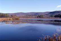
The Karner Brook Watershed ACEC contains some of the most scenic landscapes in the Commonwealth. It includes a rich diversity of wooded mountains, rolling hills, open fields, and streams, ponds, and wetlands. Hiking and scenic vistas are available from the South Taconic Trail and the Appalachian National Scenic Trail, both of which traverse the ACEC. Agricultural lands and historic and archaeological resources complement the natural beauty and resource qualities of the area.
Water Bodies included (partially or entirely) in the ACEC
- Rivers: none
- Lakes, Ponds: Marsh Pond, Mill (Smiley's) Pond (Egremont)
- Brooks, Creeks: Fenton Brook (Egremont); Karner Brook (Egremont, Mount Washington)
Maps
Karner Brook Watershed ACEC - Index Map
Karner Brook Watershed ACEC Map 15a
Karner Brook Watershed ACEC Map 15b
Karner Brook Watershed ACEC Map 15c
Karner Brook Watershed ACEC Map 15d
Maps are intended to be used with the written boundary description contained in the ACEC designation document. The mapped boundary is not to be used by itself for definitive ACEC boundary delineation or regulatory interpretation. For review of site-specific projects in or bordering the ACEC, determinations must be made in the field by a certified professional in consultation with the appropriate Conservation Commission(s) and ACEC Program Staff.