Neponset River Estuary ACEC Designation Document
Designation Amended: December 1, 1995
ACEC Resource Management Plan Approved: 5/15/96
Approximate Acreage: 1,300
Watershed(s): Boston Harbor (Neponset)
Municipalities: Boston, Milton, Quincy
The Neponset River Estuary ACEC is approximately 1,300 acres in size and is located in Boston (435 acres), Milton (355 acres) and Quincy (470 acres). The ACEC boundary is based upon the Wetlands Protection Act Regulations (wetlands resource areas and a 100-foot buffer) plus adjacent public open space and historic districts. The ACEC begins at the Lower Mills Dam in Milton and Dorchester, which separates the coastal estuary from the inland fresh water portion of the Neponset, and extends to the mouth of the river at Commercial Point in Boston and Squantum Point in Quincy.
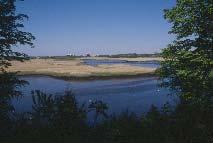
The central resource features of the Neponset River Estuary ACEC are the Neponset River and portions of its tributaries, the estuary, salt marshes, floodplains, fishery habitat, and diverse wildlife habitat. The predominant ecological and visual features of the ACEC are the Neponset River and the adjacent salt marshes. The combined acreage of open water, salt marsh, and other wetland resource areas totals approximately 830 acres, or two thirds of the ACEC. Floodplains cover approximately 1,005 acres or 80 per cent of the ACEC. The Neponset River supports valuable anadromous fishery habitat, including one of the largest smelt runs in Massachusetts Bay. Blue back herring spawn in the Neponset. Substantial soft-shell clam beds are located at the mouth of the river. Numerous other fish species are significant for commercial and recreational fishing. The Squantum Point area provides habitat for a tremendous diversity of bird species and is one of the most important wildlife habitats in the urbanized Boston area. Highly significant historical and archaeological resources (including the Dorchester and Milton Lower Mills Industrial District), recreational areas, and scenic and educational values within this area contribute to the overall significance of the ACEC to the people and communities of the region.
The Department of Conservation and Recreation (DCR, formerly Metropolitan District Commission) owns over 500 acres within the ACEC, providing a wide variety of public open space and recreational opportunities. The MDC Lower Neponset River Reservation Master Plan provides a vision for the long-term development of these properties.
Following the ACEC designation in March, 1995, Environmental Affairs Secretary Trudy Coxe directed EOEA agencies to develop a Resource Management Plan for the ACEC to guide the implementation of the ACEC designation. As part of this process, the ACEC was amended on December 1, 1995 to provide for a variety of publicly and environmentally beneficial projects. The final ACEC RMP was approved by the Secretary on May 15, 1996.
Water bodies included (partially or entirely) in the ACEC
- Rivers: Neponset River
- Brooks, Creeks: Gulliver Creek (Milton), Sagamore Creek (Quincy)
Maps
Neponset River Estuary ACEC - Index Map
Neponset River Estuary ACEC Map 17a
Neponset River Estuary ACEC Map 17b
Maps are intended to be used with the written boundary description contained in the ACEC designation document. The mapped boundary is not to be used by itself for definitive ACEC boundary delineation or regulatory interpretation. For review of site-specific projects in or bordering the ACEC, determinations must be made in the field by a certified professional in consultation with the appropriate Conservation Commission(s) and ACEC Program Staff.
Additional Resources
-
Open PDF file, 7.88 MB, Neponset River Estuary ACEC Resource Management Plan (English, PDF 7.88 MB)