Wellfleet Harbor ACEC Designation Document
Approximate acreage: 12,480 acres
Watershed/subwatershed: Cape Cod/Wellfleet Bay
Municipalities (% of ACEC): Eastham (5%), Truro (3%), and Wellfleet (92%)
The Wellfleet Harbor ACEC was nominated by the Conservation Commissions, Boards of Selectmen, and Planning Boards from the Towns of Eastham, Truro, and Wellfleet and was designated as an ACEC in 1989 because of the area’s extraordinary natural resources. The boundary for this ACEC extends from Ryder Beach in South Truro southward to Sunken Meadow Beach in Eastham and generally follows the 10-foot contour line on the landward side and the Cape Cod National Seashore boundary on the seaward side.
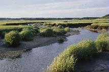
Portions of the area have been designated by the Department of Conservation and Recreation as containing visual landscapes and cultural resources that place it in the top 5% of all landscapes in the Commonwealth (1982 Massachusetts Scenic Landscape Inventory). Important habitats within the ACEC boundary include largely unaltered barrier beaches, islands, marsh systems, salt and fresh water ponds, rivers, bays, and tidal flats. These areas provide flood control, storm damage prevention, improved water quality, wildlife habitat, and recreation opportunities to surrounding communities
What coastal resources are included (partially or entirely) in the ACEC?
- Harbors, Sounds, Bays: Wellfleet Harbor, Loagy Bay, Drummer Cove, The Cove, Duck Harbor, Cape Cod Bay (Wellfleet)
- Rivers: Herring River (Wellfleet)
- Lakes, Ponds: Herring, Higgins, and Gull Ponds (Wellfleet)
- Brooks, Creeks: Hatches Creek (Eastham); Bound and Fresh Brooks, Blackfish, Duck, and Pole Dike Creeks, and Silver Spring (Wellfleet)
- Great Ponds (ponds > 10 acres): Herring, Higgins, and Gull Ponds (Wellfleet)
Outstanding Resource Waters (ORWs): Wellfleet Harbor, Duck Harbor, Cape Cod Bay, Herring River, Herring Pond, Higgins Pond, Gull Pond, Hatches Creek, Bound Brook, Fresh Brook, Blackfish Creek. (ORWs are waters, such as public water supplies and vernal pools that are protected by the most stringent standards because they constitute an outstanding resource as determined by their socio-economic, recreational, ecological, and/or aesthetic values).
Barrier Beaches included in ACEC (Massachusetts Barrier Beach Inventory, CZM, 1982): Sunken Meadow Spit (Eh-1) (Eastham); Bound Brook Beach (Tr-5) (Truro); Audubon Sanctuary (Wf-22), Blackfish Creek South Spit (Wf-14), Catboat Rd. Spit (Wf-21), Chipman Cove Spit (Wf-10), Cliff Ave. Bay Barrier (Wf-18), Duck Harbor Beach (Wf-1), Field Point (Wf-12), Great Island South Harbor Spit (Wf- 7), Great Island/Great Beach Hill Bay Barrier (Wf-3), Great Beach Hill South Harbor Spit (Wf- 5), Great Island East Spit (Wf-8), Great Beach Hill North Harbor Spit (Wf-6), The Gut (Wf-2), Hillside Ave. Spit (Wf-13), Indian Neck Tidal Inlet Barriers (Wf-11), Jeremy Point Barrier Spit (Wf-4), Lieutenant Island South Spit (Wf-19), Lieutenant Island South Marsh Barrier (Wf-20), Lieutenant Island/Loagy Bay Spit (Wf-17), Mayo Beach (Wf-9), Old Wharf Point South Spit (Wf-16), Old Wharf Point North Spit (Wf-15) (Wellfleet). (Massachusetts Barrier Beach Inventory, CZM, 1982).
Maps
Wellfleet Harbor ACEC - Index Map
Maps are intended to be used with the written boundary description contained in the ACEC designation document. The mapped boundary is not to be used by itself for definitive ACEC boundary delineation or regulatory interpretation. For review of site-specific projects in or bordering the ACEC, determinations must be made in the field by a certified professional in consultation with the appropriate Conservation Commission(s) and ACEC Program Staff.