
Project Overview
The Arborway is a nationally registered historic parkway originally designed by landscape architect Frederick Law Olmsted. Located in Jamaica Plain, it stretches from Circuit Drive at Forest Hills to Eliot Street by Jamaica Pond, where it connects to Jamaica Way, part of Boston's larger Emerald Necklace park system. Managed by the Department of Conservation and Recreation (DCR), the Arborway comprises several distinctive sections, including Murray and Kelley Circles, the Arborway and Upper Arborway adjacent to the Arnold Arboretum, and the eight-lane section between the two rotaries, which preserves Olmsted’s original parkway design. This project aims to enhance safety and accessibility for all users, provide a better balance among the various demands placed on the roadway, and create a welcoming environment that improves public access while honoring the natural and cultural history of the site.
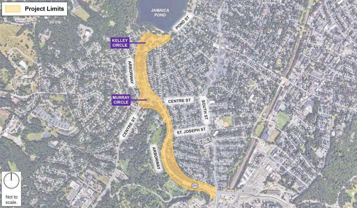
Project Limits
The project encompasses nearly the entire length of the Arborway. The northern limit extends to the southern side of Jamaica Pond, continuing south through Kelley and Murray Circles, and ending at the Forest Hills Gate, where the Casey Overpass project concluded. The scope includes both carriageways and the Upper Arborway.
The project limits are shown in yellow below.
Project Background and Development
Over the past two decades, DCR has conducted several safety and planning studies to improve the Arborway. In 2019, DCR conducted a Road Safety Audit (RSA) to assess the parkway’s existing conditions in a data-driven manner. Following a public presentation, DCR solicited proposals from design professionals to develop a plan addressing the identified issues, among other improvements.
In February 2020, DCR awarded the contract for engineering, landscape architecture, and public involvement services for the Arborway Improvement Project to Howard Stein Hudson and Halvorson Design Partnership (HSH/HDP).
HSH/HDP has developed several design alternatives, which were presented to the public and resulted in over 1,000 comments from hundreds of individuals. In 2023, DCR sought additional feedback through one-on-one meetings with community stakeholders and nearby residents, leading to further suggestions for design modifications.
Simultaneous with the development of design alternatives, HSH/HDP continued to evaluate and update the Traffic Report that was prepared during the early stages of project, which coincided with the COVID-19 Pandemic. As a result, updated Traffic Counts were conducted and analyzed in conjunction with the development of the design alternatives. (view summary of the Traffic Report)
Along with updating the Traffic Analysis, the Preferred Alternative has been refined to reflect both the updated traffic data, as well as, a number of suggested comments from the community and its stakeholders.
On January 14th, 2025, DCR hosted a virtual public meeting to present the preferred design alternative and gather feedback from the public. After reviewing the input received, DCR will use it to refine and move forward with the next phase of design, the 75% design stage. Once this stage is complete, DCR will return to the public to present the 75% design for further feedback.
Additional Resources
- Video Recording January 14, 2025 Meeting
- Arborway Improvement Project Preferred Design Alternative Public Meeting Notice 1/14/2025
- Arborway Improvement Project Preferred Design Alternative Meeting Presentation 1/14/2025
- Arborway Improvement Project Preferred Design Alternative Meeting Chat 1/14/2025
- Arborway Parkway Improvements Project – Winter/Spring 2025 Comment Summary and Responses
DCR welcomes questions on this material to mass.parks@mass.gov and the project team will do its best to promptly answer as many questions as we can.
Short Term Improvements
As the overall project design phase advances, DCR continues to plan for and execute Short Term Improvements to the Arborway to address a variety of measures, including but not limited to:

- Sidewalk and curb repairs around Murray and Kelley Circles - 2020
- Design and Establish Buffered Bike Lanes - 2021
- Gas Line Repairs – 2023 & 2024
- Revised Arborway Striping Plan – 2023
- Adding signage and striping adjacent to the Arboretum - 2024
