Project Overview
The General Services Administration (GSA) Site Improvements project encompasses the planning, design, and construction of site improvements for the former GSA property in Watertown, Massachusetts. This approximately 13-acre parcel, located between Arsenal Street and Greenough Boulevard near the Charles River, was previously used for federal programs, equipment storage, and waste burning operations. Following extensive environmental remediation completed by the U.S. Army Corps of Engineers in 2012, which included excavation and disposal of contaminated soils, mounding and capping of treated soils, and construction of compensatory wetlands, the site now operates under Activity and Use Limitations (AUL) that restrict its use to passive recreation. The site includes delineated wetlands and a small brook on the western boundary.
The Department of Conservation and Recreation (DCR) is working to transform this remediated site into a sustainable outdoor destination where visitors can enjoy passive recreation in nature while protecting the site’s ecological integrity. The project vision focuses on creating a network of universally accessible walking trails and establishing limited public access points that will protect wetland plantings and natural habitat while connecting the site to the broader DCR park and trail network along Greenough Boulevard and the Charles River. The design approach emphasizes landscape protection and restoration, climate resilience, and incorporation of the site's existing natural features and surrounding resources. All proposed improvements must comply with the Land Use Control Implementation Plan (LUCIP) requirements and support the U.S. Army Corps of Engineers' ongoing monitoring program for the remediated site.
Project Limits
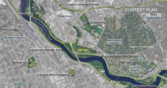
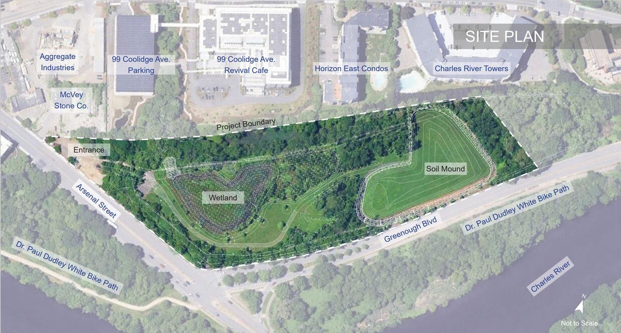
The GSA Site Improvements project covers approximately 13 acres in Watertown, Massachusetts. The site is located between Arsenal Street to the north and Greenough Boulevard to the south, near the Charles River.
All improvements will stay within the existing property boundaries. The project area includes a grassy mound in the center of the site, the wetlands that were created during the cleanup, drainage areas, and paths around the edges of the property. A "limit of work" will be established during design to protect sensitive areas and avoid disturbing the soil cap that covers the cleaned-up contaminated areas. The project will create trail connections to the surrounding DCR park system and the Charles River multi-use path along Greenough Boulevard.
The project limits are shown by the dashed line below:
Project Background and Development
Early Federal Use of the Property (1920-1967) The U.S. Army acquired this 13-acre property from the Commonwealth of Massachusetts in 1920 as part of the historic Watertown Arsenal. During the 1940s and 1950s, the Army used the site for landfilling, storing military equipment and vehicles, and managing salvage materials. Between 1961 and 1967, the Army operated a "burn box" area where depleted uranium metal chips from Arsenal machining operations were burned to make them chemically stable before being shipped off-site for proper disposal. In 1967, the property was transferred to the General Services Administration (GSA), which used it for storage and auction of excess federal property among other industrial uses.
Environmental Investigations and Cleanup (1990-2014) Beginning in 1990, environmental investigations discovered soil contamination, including PCBs (polychlorinated biphenyls), dioxin, and metals. The contamination likely came from oil used in the uranium burning process and other site operations. After years of studies and planning, the U.S. Army Corps of Engineers completed a major cleanup between 2012 and 2014. The cleanup involved removing highly contaminated soil and disposing of it off-site, creating a two-acre soil mound covered with 24 inches of clean soil to cap the remaining contamination, and building new wetlands to replace wetlands lost during construction. The site now operates under Activity and Use Limitations (AUL) that restrict its use to passive recreation only.
Current Status and Future Plans DCR manages the site and plans to transform it into a nature-focused park with walking trails and limited public access. The U.S. Army Corps of Engineers continues to monitor the site regularly to ensure the soil cap and wetlands are functioning properly. The GSA Site Improvements project will create accessible trails, protect the site's ecology, and connect it to the surrounding Charles River park system while respecting all environmental restrictions.
Contact
Online
Phone
Open M-F 9am-5pm