Downloads
(ESRI Shapefile)
Overview
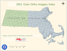
The polygon feature class, named COQ2021INDEX_POLY, is an index for the original GeoTiff images and the MassGIS-produced JPEG 2000 images. It stores the Web links for the JPEG 2000 free downloads. Each tile measures 1,500 m x 1,500 m.
Production
The GeoTiff/JPEG 2000 index polygons were delivered to MassGIS with the imagery from Quantum, one index for each of the two UTM Zones (18N and 19N) that cover Massachusetts. MassGIS projected each layer to the NAD 1983 Mass. State Plane Mainland Meters coordinate system and merged them into this one feature class, and added some attribute fields. Note that MassGIS did not project the imagery; all imagery was kept in the original UTM projections as delivered by the USGS.
Attributes
The COQ2021INDEX_POLY polygon attribute table contains the following fields:
| Field | Description |
|---|---|
| TILENAME | Unique 11-character ID for each 1,500m x 1,500m tile. Image names that begin with "18" are referenced to the UTM NAD 1983 (2011) Zone 18N coordinate system. Image names that begin with "19" are referenced to the UTM NAD 1983 (2011) Zone 19N coordinate system. |
| URL | Web link for downloading JPEG 2000 tiles |
| ZONE | UTM Zone |
Maintenance
MassGIS maintains this layer. No updates will be added.
| Date published: | January 31, 2022 |
|---|---|
| Last updated: | January 31, 2022 |