Downloads
.zip file contains an Excel spreadsheet, a point feature class shapefile, and three raster (image) datasets as described below, plus ArcGIS layer files (.lyr).
Overview
This dataset contains an Excel spreadsheet, one point feature class, and three raster (image) datasets.
The raster images are models that provide an estimate of the altitude of the bedrock surface and thickness of the overburden across Massachusetts at a resolution of 100 meters. The models are based on 678,836 data points including 61,467 bedrock wells or geophysical survey data points, 111,495 bedrock outcrop points, 492,120 shallow-to-bedrock area data points and 13,754 overburden wells. Each data point contains a bedrock altitude and depth along with a location. Accompanying the altitude and thickness rasters is an image that portrays the combined depth to bedrock measurement uncertainty and the kriging prediction standard error produced with the modeling.
The datasets include:
- A Data Set of Depth to Bedrock Described in Drill Holes and Geophysical Surveys for Massachusetts – Release 1 – This data set is a spreadsheet that contains drill hole and geophysical survey data compiled from 27 different sources. It contains 107,702 records. Each record contains location information and can be imported directly into ArcGIS. See a description of how the data were collected and processed.
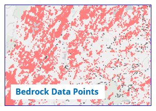
- A Data Set of Drill Hole, Bedrock Outcrops, Shallow to Bedrock Areas, and Selected Overburden Wells From Mainland Massachusetts Used to Model the Altitude of the Bedrock Surface and Depth to Bedrock (BEDROCK_DATA_POINTS) – This point feature class contains all the point data used in the models to generate the bedrock altitude and depth to bedrock rasters. There are a total of 678,836 records in this data set.
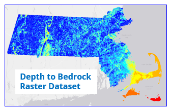
- Depth to Bedrock Determined from Subtracting Bedrock Altitude from Topography for Massachusetts at 100-meter Resolution (BEDROCK_DEPTH_IMG) – This raster shows the thickness of the overburden across Massachusetts at 100-meter resolution. This raster image is a model of the depth to bedrock at 100-meter resolution determined by subtracting an altitude model of the bedrock surface from topography; all at 100-meter resolution. The altitude model from which the depth to bedrock is estimated is based on the data points feature class.
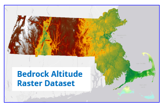
- Map of the Bedrock Altitude for Massachusetts at 100-meter Resolution (BEDROCK_ALTITUDE_IMG) – This raster is a model of the altitude of the bedrock surface at 100 meter resolution and was derived from the data points feature class. Bedrock altitudes range from a high of 1059 meters (above NAVD88) at Mount Greylock to a low of -512 meters on Nantucket.
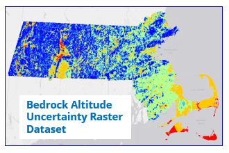
- Map of Combined Bedrock Altitude Kriging prediction standard errors and Measurement Uncertainties for Massachusetts at 100-meter Resolution (BEDROCK_UNCMODERR_IMG) – This raster portrays the combined kriging prediction standard errors and depth to bedrock measurement uncertainties at 100-meter resolution. The kriging prediction standard errors for each grid cell are produced as output from the empirical Bayesian kriging process. The measurement uncertainties are assigned to the data by the authors based on who acquired the depth to bedrock data, the specific source of the data, or the method of data acquisition (drill hole or geophysical method).
Production
Multiple agencies and individuals contributed to these data products. The work was done in cooperation with the Massachusetts Geological Survey, University of Massachusetts Department of Earth, Geographic, and Climate Sciences, GISmatters, Inc., and Tufts University Department of Civil and Environmental Engineering, with input from the U.S. Geological Survey. This work was funded by the Massachusetts Department of Transportation (Award Number INTF00X02021A0113776) and the Massachusetts Emergency Management Agency (Award Number ISACDAHM437905UM821A).
Input data for the models were collected from 27 different sources including field work conducted in the summer 2021 and 2022. Bedrock outcrop and shallow to bedrock data were extracted from the Surficial Materials of Massachusetts – A 1:24,000-Scale Geologic Map Database (Stone and others, 2019). Input data were modeled using a combination of empirical Bayesian kriging and co-kriging. Accompanying the altitude and thickness rasters is an image that portrays the combined depth to bedrock measurement uncertainty with kriging prediction standard errors produced with the modeling.
See complete documentation on how the data for this project were collected, processed and modeled.
Suggested Citation:
Mabee, S.B., C.C. Duncan, W.P. Clement, and M.A. Pontrelli, 2023, Massachusetts Depth to Bedrock Project. MassDOT Office of Transportation Planning, Research and Technology Transfer Section, Research Report, 173 p.
Related Data Layer
Also see the NEHRP Soil Classifications feature class.
Attributes
Fields in the BEDROCK_DATA_POINTS attribute table:
| Field name | Description |
|---|---|
| SITE_UID | Site unique identifier |
| DATASET | Name of the source data set defined in the DataSets sheet |
| NORTHING_M | Northing of the boring or subsurface measurement point given in the Massachusetts State Plane Coordinate System, meters |
| EASTING_M | Easting of the boring or subsurface measurement point given in the Massachusetts State Plane Coordinate System, meters |
| SURF_EL_M | Surface elevation of data point |
| UNCERT_M | Estimate of the uncertainty in the depth measurement in meters |
| BOR_FLAG | Flag that identifies whether the data point was a bedrock point or was an overburden point providing a minimum depth to bedrock or maximum altitude of bedrock |
| LIDAR_M | Surface elevation of data point obtained from the 1-meter resolution statewide Lidar DEM in meters |
| USE_ALT_M | Altitude of the bedrock or maximum altitude of the bedrock for overburden wells. Use this value when modeling bedrock altitude |
| USE_DTB_M | Depth to bedrock or minimum depth to bedrock for overburden wells in meters. Use this value when modeling depth to bedrock |
Maintenance
The Massachusetts Geological Survey (MGS) maintains the data. The depth to bedrock rasters are static products that do not require active maintenance or updates. Over the long term, these raster files may need to be depreciated and/or swapped out with new raster files if new depth to bedrock maps become available from the MGS.