Downloads
Overview
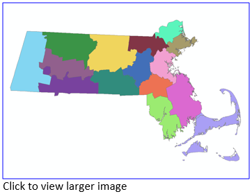
The MA State Fire Districts were established by Executive Order No. 221 on June 30, 1982 by Governor Edward King. They are organized and coordinated under the Executive Office of Public Safety and Security. Each State Fire District is responsible for working together internally with the member fire departments to provide mutual assistance to one another on a routine basis and externally with other State Fire Districts when an incident occurs that overwhelms a single district’s resources by activating the statewide fire mobilization plan. The district layer was created by coding each town with numbers 1-15 and then dissolving the town boundaries.
This layer is stored in ArcSDE and distributed as DFS_SFD_POLY.
Updated in August 2021 to be based on the Survey Towns Boundaries (previously based on the USGS-based town boundaries).
Attributes
The polygon attribute table contains the following fields:
| Field | Description |
|---|---|
| STATE_FIRE | Fire District Number |
| COUNT_SF | A count of the local fire departments and districts that make up each state fire district |
| FIRST_DEPT | First department in the district, alphabetically |
| LAST_DEPT | Last department in the district, alphabetically |
Maintenance
The Massachusetts Department of Fire Services will provide any updates to MassGIS.
Updated in April 2022 to reflect recent edits to the Municipalities layers.