Downloads
Overview

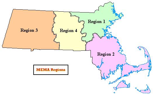
The MEMA Regions layer represents boundaries used by the Massachusetts Emergency Management Agency for planning and administrative purposes. The data layer is considered unclassified information and was developed to meet Homeland Security Infrastructure Program requirements. The coverage was joined to the MassGIS Towns layer on TOWN_ID by MEMA staff. MassGIS dissolved the layer on region name.
The ArcSDE layers and Data Viewer shapefiles are named REGMEMA_POLY and REGMEMA_ARC.
The polygon feature class was updated in August 2021 to be based on the Survey Towns Boundaries (previously based on the USGS-based town boundaries).
Attributes
The polygon attribute table contains the following items:
| Item | Description |
|---|---|
| NAME | Region Name |
| PHONE | Region Phone Number |
| POP2000 | Region Population, 2000 |
The arc attribute table contains the following items:
| Item | Description |
|---|---|
| OUTLINE | Boundary type: 9 = MEMA internal boundary 1 = State outline 4 = Coastline |
Related Database Table
The table REGMEMA_POLY_TOWNS identifies which towns fall within each MEMA region. Items include:
| Item | Description |
|---|---|
| TOWN_ID | Municipality ID, from Municipalities layer |
| NAME | Region Name (same as NAME item in polygon attribute table) |
Maintenance
MEMA will provide any updates to MassGIS.
Updated in April 2022 to reflect recent edits to the Municipalities layers.