Downloads
Download .zip file includes four shapefiles and ArcGIS layer file (.lyr)
Overview
As a response tool, the GRS allows quick decisions by providing detailed geographic information on shoreline types and sensitive cultural, economic, historical, and natural resources. This information, together with estimates of response equipment requirements, staging locations, and pre-identified deployment strategies for protecting sensitive environmental areas, provides a basis for local responders to develop a more effective and coordinated initial response. Geographic Response Strategies also provide important information to the oil spill incident management team in planning and implementing the environmental response to an oil spill. GRS are usually part of the Area Contingency Plan (ACP) that each USCG Sector is required to maintain to enhance preparedness and prevention activities for all coastal areas of the United States.
In support of the Massachusetts Geographic Response Strategies, MassDEP has provided oil spill response equipment and trailers to 71 coastal municipalities and two MassDEP regional offices.
The equipment to be used by local spill responders will provide the rapid response capability necessary to contain a spill at its source and to protect or prevent oiling of sensitive habitats and important resources. The equipment serves as an important response asset in the event of a localized spill as well as for a spill of regional scope.
Each coastal municipality in possession of a MassDEP oil spill response trailer has signed the Commonwealth Standard Contract forms that establish terms and conditions regarding the custody and use of the oil spill response equipment. These agreements allow municipalities to use the equipment for certain defined purposes. At the same time, the Commonwealth of Massachusetts retains ownership of the equipment as well as the responsibility to maintain and restock the trailer and equipment and may relocate oil spill trailers from one community to another as needed to address the resource management needs of an oil spill event.
MassDEP maintains a website to provide training and inventory information pertaining to this oil spill equipment, including locations and local points of contact at https://www.mass.gov/how-to/find-oil-spill-trailer-locations.
Methodology
In 2007 MassDEP contracted with Nuka Research to prepare GRS for all coastal areas. One of the deliverables was GIS data representing where boom should be employed, what tactics to use (and where), and the locations of other relevant points. GIS data was developed by onscreen digitizing with an orthophoto base map. These were delivered as four individual layers.
- The GRS_BOOMS_ARC layer contains line features demarking the planned deployment location and type of boom for intercepting and or absorbing oil.
- The GRS_TACTICS_PT layer contains point features depicting the tactic for containing or cleaning up oil to be employed at that location.
- The GRS_OTHER_PT layer contains points depicting a variety of other relevant features.
- The DEP_OSR_TRAILER_PT_ layer contains points of the approximate oil spill response equipment locations.
Organization of Geographic Response Strategies
GRS are developed for specifically identified sites based on their environmental, economic, historical or cultural sensitivities. There are 160 sites around Massachusetts with corresponding response strategies. These sites are grouped into areas. A GRS will typically contain booms, tactics, and probably other points. Three out of the four GRS layers share several fields regarding the site’s location and references to the GRS, of which a feature is a part.
Displaying These Data
The layer files provided by Nuka Research to MassDEP and distributed with the data by MassGIS were designed to closely mimic the symbology used in the GRS documents.
Attributes
Shared Attributes for GRS Layers
The GRS layers contain the following attribute elements:
| Field Name | Description |
|---|---|
| GRS_AREA_C | A code for the GRS Area of the state: NS = North Shore BH = Boston Harbor SS = South Shore BB = Buzzards Bay CI = Cape & Islands MHB = Mount Hope Bay |
| SITE_ID | Unique site identification number. These numbers are only unique within a GRS Area, not across the state. |
| SITE_NAME | The name of the site. |
| SITE_NUM | Unique site identification number |
| GRS_LINK | The URL for the GRS of which that feature is a part. This field can be used to create a hyperlink to the PDF document. |
Layer Specific Attributes for GRS Layers
GRS_BOOMS_ARC
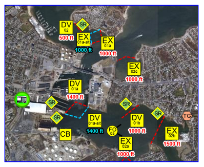
A collection of lines representing specific boom types such as open water boom and protected water boom or other recovery equipment and techniques such as beach berm and snare or sorbent boom. These lines are measured in feet, and sizes vary depending on the tactic.
| Field name | Description |
|---|---|
| TACTIC_TYP | A code for the tactic type: TG = Tide Gate BB = Beach Berm CB = Culvert Block DF = Deflection Booming DV = Diversion Booming EX = Exclusion Booming FO = Free Oil Recovery HB = Hurricane Barrier PR = Passive Recovery SR = Shoreside Recovery |
| TACTIC_NUM | Tactic number identifier |
| BOOM_TYPE | The type / purpose of the boom: OWB = Open Water Boom BB = Beach Berm Material PWB = Protective Water Boom Flood Tide PWBE = Protective Water Boom Ebb Tide PWBC = Protective Water Boom, Strategy developed by others SSB = Snare or Sorbent Boom |
| BOOM_LEN | Length of the boom leg in feet |
| TIDE | Tide in which the tactic is feasible |
| MAR_ANCH | Number of marine anchors needed for the tactic |
| SHORE_ANCH | Number of shoreline anchors needed for the tactic |
| COOP | Booming strategy developed by another agency |
GRS_TACTICS_PT
A cluster of points that symbolize the tactic strategies. Five different response strategies and four different recovery tactics are depicted in the data set.
| Field name | Description |
|---|---|
| TACTIC_TYP | A code for the tactic type: TG = Tide Gate BB = Beach Berm CB = Culvert Block DF = Deflection Booming DV = Diversion Booming EX = Exclusion Booming FO = Free Oil Recovery PR = Passive Recovery SR = Shoreside Recovery |
| TACTIC_NUM | A reference number used in the GRS for that tactic at that location |
| BOOM_LEN | Length of the boom leg in feet |
| TIDE | Tide in which the tactic is feasible |
| MAR_ANCH | Number of marine anchors needed for the tactic |
| SHORE_ANCH | Number of shoreline anchors needed for the tactic |
| BOOM_CONFI | Configuration of the boom legs: Single leg, cascade, or chevron |
| TEST_DATE | Date in which the specific tactic was tested |
| BOOM_TYP | The type / purpose of the boom: OWB = Open Water Boom BB = Beach Berm Material PWB = Protective Water Boom Flood Tide PWBE = Protective Water Boom Ebb Tide PWBC = Protective Water Boom, Strategy developed by others SSB = Snare or Sorbent Boom |
| COOP | Booming strategy developed by another agency |
| TESTED_Y_N | Y= Tactic has been tested. Refer to TEST_DATE for exact date. N= Tactic has not been tested |
GRS_OTHER_PT
An array of miscellaneous points important for situational awareness during a response. These points include but are not limited to boat ramps, access points, Coast Guard stations, hurricane barriers, I-beams, lighthouses, locks, mosquito ditches, permanent attachments, pump stations, response trailers, staging areas, tidal gates, wash over points, and water intakes.
| Field name | Description |
|---|---|
| P_TYPE | Description of the point type: AP = Access Point BR = Boat Ramp CG = Coast Guard Station HB = Hurricane Barrier IB = I-Beam L = Lock MD = Mosquito Ditch PA = Permanent Attachment PS = Pump Station RT = Response Trailer SA = Staging Area TG = Tidal Gate WI = Water Intake WO = Wash Over Point |
| POINT_DESC | Description of the point type |
DEP_OSR_TRAILERS_PT
| Field name | Description |
|---|---|
| SITE_NAME | A descriptive name for the trailer site. Typically, the name of the town in which the trailer resides. |
| REGION | The GRS regions are Boston Harbor, North Shore, South Shore, Cape and Islands, Buzzards Bay, and Mt. Hope Bay |
| FUNDING SO | Internal MassDEP funding source for trailer purchase |
| MANUFACTUR | Date when the trailer was built. This is reflected on the trailer’s metal manufacturing plate. |
| LATITUDE | Latitude to identify location of the site |
| LONGITUDE | Longitude to identify location of the site |
| TRAILER TY | A description of the trailer type such as 12, 16, or 20 feet. |
| PLATE NUM | Plate number registered to the trailer |
| VIN | Unique Vehicle Identification Number stamped on the manufacturer plate. |
| CUSTODIAN | Party responsible for the trailer |
| TELEPHONE | Phone number to contact the custodian responsible |
Maintenance
This data is currently maintained by Nuka Research and provided to the MassDEP Oil Spill Prevention and Response Program for public distribution through MassGIS.
Nuka Research was contracted in 2021 to modernize the GRS template and GIS project in collaboration with MassDEP. In addition to a new template, Nuka Research reviewed and updated each existing GRS. As a result, in addition to the three GRS layers previously provided to MassDEP, an additional layer, DEP_OSR_TRAILERS_PT, has been added to the geospatial data package.
In December 2022, the three GRS layers were updated with revised URLs in the GRS_LINK field.
The preparation and funding of these response strategies has been a major focus of MassDEP's efforts to enhance Massachusetts's overall coastal oil spill response and preparedness posture. Review GRS for Massachusetts coastal areas. Questions regarding this data should be referred to MassDEP’s Marine Oil Spill Prevention & Response Coordinator.
Contact Information:
Phone: 1-617-292-5500
Email: BWSC.information@mass.gov
These layers replace the older Geographic Response Plan (GRP) data.