Downloads
Overview
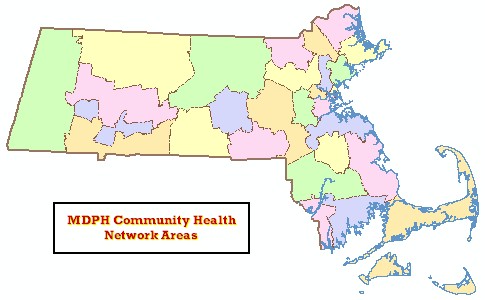
The MDPH Community Health Network Areas (CHNA) layer represents 27 administrative boundaries used by the Office of Healthy Communities (OHC), Massachusetts Department of Public Health (MDPH).
MDPH established the CHNA effort in 1992. Each CHNA is a coalition with broad-based membership from the public, non-profit and private sectors, such as local health and human service agencies, schools, consumers, faith-based communities, businesses and many other partners interested in working to enrich their community. The mission of the statewide network initiative is to enhance access to care, provide an opportunity for greater collaboration, and to create a client-centered, outcome-oriented health service delivery system in each community. CHNAs promote efficiency and enhance the effectiveness of community-based services by reducing duplication and gaps and by increasing health promotion and prevention services.
The source material for this datalayer was compiled by Cathy O'Conner, Director, OHC, MDPH. This GIS datalayer is derived from the Municipalities layer.
This polygon layer is stored at MassGIS as CHNA_POLY. A line layer is named CHNA_ARC.
Production
In Access 2000, the CHNA information was joined to the attribute table of the MassGIS Municipalities datalayer (TOWNSSURVEY_POLY) based on town name. In ArcMap (v9.0, build 560), a dissolve was performed on the new MassGIS Community Boundaries from Survey Points attribute table/datalayer based on CHNA name. The new feature class was renamed. In Access 2000, the CHNA_NUM field was manually inserted into the attribute table using the original CHNA information as a reference. Processing was completed by staff at MDPH, Center for Environmental Health.
Attributes
The CHNA_POLY attribute table contains the following fields:
| Item Name | Description |
|---|---|
| CHNA_NUM | Number that corresponds to 1 of 27 CHNAs. Note that CHNA number 19 is assigned to two polygons (Alliance for Community Health and Harbor Community Health Alliance). Both are considered parts of CHNA 19, but each is assigned to specific municipalities. |
| CHNA_NAME | Facility Name of CHNA |
The CHNA_ARC attribute table contains the following field:
| Item Name | Description |
|---|---|
| TYPE | Boundary type: 1 - CHNA 2 - State 4 - Coastline |
Maintenance
MDPH maintains the layer and will provide any updates to MassGIS. For more information on CHNAs visit the DPH website.