Downloads
Overview
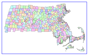
The function of the MSAG is twofold. Firstly, it is a tool to keep street names unique within a municipality in the Commonwealth. (The combination of street name and MSAG Community is unique in all cases but 23, 20 of which occur in one town.) The MSAG also is the repository for the official 911 spellings of street names. The MSAG includes three pieces of information relevant to the creation of the MSAG community boundaries: COMMUNITY, STREET NAME and their associated ADDRESS RANGES. The address range is composed of a high number, a low number and parity, which indicates whether the range is odd, even or both. In most cases an MSAG community matches the boundaries of the 351 official municipalities in the commonwealth. Some cities and towns are divided into more than one MSAG community. In total there are 381 MSAG communities in Massachusetts. The data layer is incorporated into MassGIS' Master Address Database (MAD) and is named MAD_MSAG_COMMUNITY_POLYM.
Production
The methodology for creating the MSAG community boundary layer can be summarized as follows: Where a town was composed of only one MSAG community the official town boundary from the Survey-based Massachusetts Communities data layer was used. In these cases the MSAG community is identical to that in TOWNSURVEY_POLYM. For towns with more than one MSAG community, parcel data available in 2008, when the layer was created, were used to help determine the boundaries. The process for creating communities within these multi-community towns was essentially a matching exercise between the MSAG and parcels. Street names were compared and parcels were selected where the street name matched and the parcel address was within the MSAG range. Areas of ambiguity, where the parcel address did not match an MSAG value exactly, were assigned a community based on rules that included values in the NAVTEQ streets layer, relative location of the parcel, proximity to streets, and the portion of the address value that did match the MSAG. The vintage of the parcel data used in creating MSAG boundaries varies and can be as old as 2004.
In all but one case the MSAG communities are nested within the Survey-based Massachusetts Communities data layer. The one exception is Devens. The MSAG community of Devens occurs in parts of three municipalities, Ayer, Harvard and Shirley and is split along those town boundaries. Therefore there are 383 MSAG community polygons in the state. Ten municipalities are further subdivided into more than one MSAG community. They are Barnstable, Boston, Deerfield, Dennis, Harvard, Nantucket, Northampton, Palmer, Shirley and Springfield. The spelling of MSAG communities does not always agree with the official spelling of the town name. For example the town of North Attleborough is associated with the MSAG community of North Attleboro. Where towns are subdivided into multiple MSAG communities they are not a representation of villages or ZIP Code areas. Although MSAG community values are often the same as village names they do not represent a comprehensive listing of the villages for that town nor are they the limits of villages where the names agree. The MSAG was based on keeping the combination of street names unique and only where there was ambiguity was a MSAG community created. The MSAG community layer also includes communities in surrounding states that border Massachusetts.
Attributes
The MSAG Community boundary datalayer layer contains the following fields:
| Field name | Description |
|---|---|
| COMMUNITY_ID | Numeric identifier for each MSAG community. Communities in Massachusetts are numbered 1-381; those out of state have 7-digit numbers. |
| COMMUNITY_NAME | MSAG community name. Communities outside Massachusetts have a suffix of the state abbreviation. |
| ADDRESS_TOWN_ID | The official Town ID (1-351) for Massachusetts municipalities. This field is null for out-of-state communities. |
| STATE | State abbreviation. |
The combination of the first three fields uniquely identifies an MSAG polygon.
Disclaimer
This data set, like all other cartographic products, may contain inherent aberrations in geography or thematic errors. The boundaries included in this data set were developed using accepted GIS methodology. Cartographic products can never truly represent real-world conditions because of several factors. These factors can include, but are not limited to: human error upon digitizing, computational tolerance of the computer, or the distortion of map symbology. Because of these factors MassGIS cannot be held legally responsible for personal or property damages resulting from any type of use of the data set. These boundaries are suitable for map display and planning purposes. They cannot be used as a substitute for the work of a professional land surveyor.
Maintenance
MassGIS maintains this data layer and will make any edits as needed. Also see the Emergency Service Zones data and learn about the Next Generation 911 Emergency Call System.