Downloads
Download these data -- Each download is a Windows compressed .zip file.
There are several download options for the data, depending on the software you plan on using to view the data:
Shapefiles (29 MB) – For those with GIS software from ESRI (ArcGIS), or other commercial or open-source GIS software. Includes ArcGIS 9.0/9.1 layer (.lyr) file and Chapter 91 Final Report.
Personal Geodatabase (CZM.mdb file) (30 MB) – original format provided by the contractor, compatible with ESRI's ArcGIS 9.1 and above. Includes ArcGIS 9.1 layer (.lyr) file and Chapter 91 Final Report.
ArcReader application with data (263 MB) – For those with no GIS software. ArcReader is free GIS-viewing software from ESRI. This option comes with the ArcReader software (zip file) and data (mdb file), installation / setup instructions and user guide, plus an ArcReader Tutorial and tutorial data. Includes the Chapter 91 Final Report.
Also: Two (Coastal & Inland) file geodatabases with georeferenced raster images of source Maps and Plans that were used in the development of the historic data may be downloaded here.
Overview

Documenting the extent of tidelands jurisdiction is important because of the public’s rights in tidelands, and their associated regulatory and legal implications. Under the Public Trust Doctrine the Commonwealth is charged with the protection of public interests in all tidelands. Together, Chapter 91 and the Waterways Regulations guide development in a manner that protects, promotes, and preserves the public’s interest in tidelands by establishing performance standards for projects in these areas.
The Waterways regulations, 310 CMR 9.02, define tidelands as “present and former submerged lands and tidal flats lying between the present or historical high water mark, whichever is farther landward, and the seaward limit of state jurisdiction.” The Tidelands Jurisdiction data include a set of contiguous line segments based on either the historic high water mark or the approximate current high water mark. Sites located seaward of the contiguous line are presumed to be in c. 91 jurisdiction. The data are intended to assist state regulatory agencies and the public with determinations of tidelands jurisdiction. They must be used together, since the jurisdiction consists of one or more of the data layers (see “Use of DataLayers” section below). In cases where the current mean high water mark defines the limit of jurisdiction, c. 91 jurisdiction cannot be precisely determined by using the data, and must be established by field inspection.
Data Development
The Massachusetts Office of Coastal Zone Management (CZM) contracted with The BSC Group, Inc. to map tidelands jurisdiction for use by MassDEP, pursuant to Chapter 91 and the Waterways Regulations (310 CMR 9.00). The project used a comprehensive methodology to map the landward extent of Chapter 91 jurisdiction, whether based on historic or contemporary high water lines.
Contemporary high water and other contemporary data were developed from several sources, and in all cases must be field-verified for c. 91 licensing purposes:
- Visual interpretation: The limits of contemporary shoreline were interpreted as the wet/dry interface on the digital orthoimagery and manually digitized.
- LIDAR: The National Oceanic and Atmospheric Administration (NOAA) provides access to LIDAR (LIght Detection And Ranging) data through its LIDAR data retrieval website for much of the Massachusetts coastline. Where available, datum-referenced LIDAR data was the preferred method of depicting the contemporary coastline.
- NOAA high and medium resolution shorelines: NOAA has made available contemporary shoreline data using geo-referenced versions of current nautical charts.
The historic high water data was developed using maps and plans from the mid-1800s to the present, with the following steps:
- Research to locate maps and plans (digital and paper) containing information relevant to mapping tidelands jurisdiction
- Evaluation of maps and plans to determine which plans to use to derive one or more of the nine component data layers
- Scanning and registration of plans
- Converting or extracting the desired data from maps and plans
Full details of the development of the Tidelands Jurisdiction data can be found in Massachusetts Chapter 91 Mapping Project, Final Report and in the detailed metadata of the individual data layers (see below).
Attributes
The layer's arc attribute table has the following items:
| Field Name | Comments |
|---|---|
| Boundary | Numeric code matching feature type |
| Feature | Federal/State boundary definition |
What MassDEP Provides
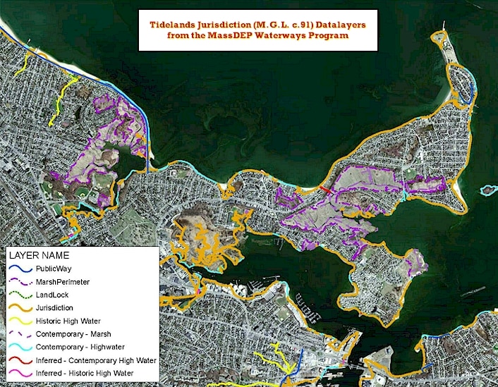
The data cover the entire Massachusetts coast including Cape Cod, Martha’s Vineyard, and Nantucket. They do not include Provincetown, which was mapped in 1995, and the Elizabeth Islands. The following nine datalayers comprise the Tidelands Jurisdiction data set (layer names appear in parentheses after the description).
Historic High Water
The historic high water lines were derived from various historical plans, and depict the most reliable landward shorelines prior to filling activities. The historic high water lines were established to determine presumptive lines of Chapter 91 tidelands jurisdiction. (CZM_HISTORIC_HIGHWATER)
Contemporary High Water
The contemporary high water layer represents the approximate present day high water lines as derived from a visual interpretation and manual digitization of digital orthoimagery, and from LIDAR (LIght Detection And Ranging) data as obtained from the National Oceanographic and Aeronautical Administration (NOAA). (CZM_CONTEMP_HIGHWATER)
Inferred Historic High Water
Straight lines digitized across the base of historic wharves, bridges, roads, and other coastal structures depicted on historic plans in locations where no reconstructed shoreline could be identified. (CZM_INFERRED_HISTORIC)
Inferred Contemporary High Water
In the areas where contemporary high water was not visible from the orthoimagery because of existing wharves, building overhangs, or bridges that obscured shoreline location, a line was constructed at the landward base of the structure. (CZM_INFERRED_CONTEMP)
Marsh Boundary – Landward
The approximate landward or back edges of contemporary marsh as depicted on the Commonwealth of Massachusetts DEP's as provided by MassGIS. (CZM_MARSHPERIMETER)
Marsh Boundary – Seaward
The approximate seaward boundaries of present day marsh areas as derived from a visual interpretation and manual digitization of digital orthoimagery. (CZM_CONTEMP_MARSH)
Landlocked Tidelands
Landlocked tidelands are those portions of filled tidelands that lie landward of a line located 250 feet from contemporary high water boundaries, or the seaward limit of the first public way (in existence prior to January 1, 1984) encountered inland from contemporary high water, whichever is farther from contemporary high water. (CZM_LANDLOCK)
Jurisdiction
The portion of the historic high water line that is not landlocked in accordance with the definition of that term in 310 CMR 9.02. (CZM_JURISDICTION)
Public Way
The approximate centerline of roadways as derived from a visual interpretation and manual digitization of digital orthoimagery. The public way lines were used to help determine the limits of jurisdiction and the locations of landlocked areas. Not all public ways were verified to have met the definition of public way at 310 CMR 9.02, therefore public ways must be verified. (CZM_PUBLICWAY)
Use of Datalayers to Determine C.91 Jurisdiction
With the exception of present-day marsh areas, a continuous line of approximate c. 91 jurisdiction can be obtained by using a combination of the “Jurisdiction,” “Contemporary High Water,” “Inferred Contemporary High Water,” “Inferred Historic High Water,” and “Landlocked Tidelands” datalayers. The “Historic High Water” and “Landlocked Tidelands” lines form the approximate landward and seaward boundaries of landlocked tidelands, which are not regulated by DEP.
Related Files
Also included with these data are the following:
- ArcReader application (includes free copy of ArcReader 9.3 program) – contains the set of 9 related data layers, plus some base data
- Chapter 91 Mapping Project Final Report, BSC Group
- ArcGIS layer (.lyr) files
Data Limitations
The historic high water line is intended to represent the presumptive MassDEP jurisdictional line on filled tidelands. In the absence of additional information, DEP will consider the line to represent the historic high water mark. All other layers are considered to be approximate and subject to verification on a site by site basis.
Maintenance & Updates
The MassDEP GIS Program will maintain these data in cooperation with the MassDEP Waterways Program. The Tidelands Jurisdiction data layers will be updated on an ‘as needed’ basis. For questions on these data please contact the MassDEP Waterways Program at 617-292-5929 or DEP.Waterways@mass.gov