Downloads
Overview
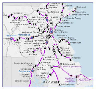
The layer includes active passenger, freight, and MBTA Commuter Rail and Rapid Transit railways, along with abandoned rail lines and railroad beds now used as rail trails. In many instances there is more than one track per rail line, and rail yards and spurs are included.
The Central Transportation Planning Staff updated and enhanced railroad linework distributed by the United States Geological Survey (USGS) as 1:100,000 Digital Line Graphs (DLGs). The original 1:100,000 DLG data were conflated to the orthophoto-derived 1:5,000 Centerline linework now used in this layer. CTPS added several attributes pertaining to type of service, MBTA Commuter Rail status, rail line ownership, and freight and passenger operation.
The statewide layers are named TRAINS_ARC (rail lines), TRAINS_NODE (named station locations) and TRAINS_RTE_TRAIN (MBTA Commuter Rail Routes (a dissolved subset of TRAINS_ARC). In addition, the MBTA Rapid Transit data are stored in separate layers (subway, trolley, Silver Line railways and T stops).
Production

CTPS transferred the attributes from the old trains data layer and has added many more. CTPS used track charts, railroad timetables, old maps, University of New Hampshire website, railroad websites, books, rail experts and field work for sources of information.
The lines and branches in the arc layer represent the most current name for the rail line while the route feature class has more names for same line. One line may be named differently and have different beginning and ending points because of historic changes or because of passenger operations and freight operations on the line. The route system contains routes based on several sources. The route source item identifies its source. The karr_rt is the numbering system depicted in "The Rail Lines of Southern New England" by Ronald Karr. The 189 routes include the Amtrak Downeaster, Amtrak Northeast Corridor, the MBTA Commuter Rail lines, and others.
Segments of rail trails that are in the railroad right-of-way have been added. Track numbers were coded where track charts were available to delineate them.
The node layer contains station names and links to the Federal Railroad Administration's Crossing database (crossing), the National Bridge Inventory (bin, alt-bin) and MassHighway Road Inventory data layer (csn).
MassGIS received data from CTPS and converted the route and node layers directly to ArcSDE format. The arc feature class was dissolved on all fields to remove pseudo-nodes before being imported to SDE. MassGIS also performed some quality assurance on the data.
Attributes
The TRAINS_ARC attribute table includes the following fields:
| Item Name | Width/Type | Description |
|---|---|---|
| TYPE | 2 / I | Type of service. See TABLE 1 below |
| SOURCE | 5 / C | See TABLE 2 below |
| COMMRAIL | 1 / C | Commuter Rail status. See TABLE 3 below |
| OWNERSHIP | 10 / C | See TABLE 4 below |
| FREIGHT_OP | 10 / C | See TABLE 5 below |
| PASS_OP | 11 / C | See TABLE 6 below |
| COMM_LINE | 40 / C | Names of Commuter Rail lines. See TABLE 7 below |
| LINE_BRNCH | 20 / C | Line branch |
| VALPLANNUM | 6 / C | RR line no. & map no. ref. |
| VALPLANOWN | 10 / C | See TABLE 8 below |
| TRACK | 10 / I | Track no. in track chart |
| KARR_RT | 6 / C | RR rt. in Karr's book |
| YARD | 30 / C | Name of rail yard |
| FREIGHT_ML | 1 / C | B&M’s Freight Mainline |
| STATE | 2 / C | 2-character U.S. state abbreviation |
| LINE_CODE | 10 / I | Trk no. in “takings” doc |
| RAIL_TRL | 25 / C | Rail trail-(rr row prt only) |
| SPUR | 25 / C | Short side track connecting to main line |
| RT_CLASS | 5 / I | Rapid Transit rail class. See TABLE 9 below |
| RT_LINE | 20 / C | Abbreviated name for Rapid Transit line |
| RT_STATUS | 1 / C | Status of Rapid Transit line (Y = active; P = proposed) |
| MAP_ONE | 1 / C | Singles out one arc on multiple track lines for display purposes |
| DATE_ABAND | 5 / I | Year line was abandoned |
| ASSET | 10 / I | Name of tunnel (for Rapid Transit lines) |
| ASSET_ID | 25 / C | ASSET identifier |
The TRAINS_NODE attribute table includes the following fields:
| Item Name | Width/Type | Description |
|---|---|---|
| STATION | 25 / C | Station name |
| C_RAILSTAT | 1 / C | MBTA Commuter Rail station status (See TABLE 3 below) |
| AMTRAK | 1 / C | AMTRAK station ("Y" if yes) |
| MAP_STA | 1 / C | Singles out one station point ("Y") for display purposes |
| LINE_BRNCH | 50 / C | Commuter Rail line or other line/branch name on which the station is located |
| STATE | 2 / C | State in which the train station is located |
The TRAINS_RTE_TRAIN attribute table includes the following fields:
| Item Name | Width/Type | Description |
|---|---|---|
| COMM_LINE | 30 / C | Name of MBTA Commuter line |
| COMMRAIL | 1 / C | MBTA Commuter Rail line status (See TABLE 3 below) |
The following tables detail code descriptions (for TRAINS_ARC unless otherwise specified):
TABLE 1 - TYPE
| Code | Description |
|---|---|
| 1 | Active rail service |
| 2 | Multiple use i.e. active and recreation |
| 3 | Abandoned rail service |
| 4 | Abandoned rail service ROW in public ownership |
| 5 | Unknown status |
| 6 | Out of service |
| 7 | Right-of-way (ROW) used for hiking and biking |
| 8 | Other ROW (once used for trolleys, or never built or used for rail) |
| 9 | MBTA Rapid Transit |
TABLE 2 - SOURCE
These codes refer to the source of the attribute information. In addition to the coded sources, CTPS relied heavily on the University New Hampshire's website of scanned maps and the personal resources and expertise of CTPS staff person Tom Humphrey.
| Code | Description |
|---|---|
| 1890 | 1890 Topographical maps of Massachusetts (MA publisher). |
| 1938 | 1938 General Highway Maps (MA DPW publisher). |
| ASSES | Municipal assessors |
| BTS | Bureau of Transportation Statistics |
| CTPS | CTPS staff |
| KARR | Karr |
| MACOA | Mass. Coastal |
| MBTA | Massachusetts Bay Transportation Authority |
| P&W | Providence and Worcester Railroad |
| TOWN | Municipal data |
| vpmap | Valuation Section Maps of 1917 of NY, NH, &H and Central NE Lines and 1970's Boston & Main Valuation Section Map. |
TABLE 3 - COMMRAIL (arcs) and C_RAILSTAT (nodes)
| Code | Description |
|---|---|
| Y | Active MBTA Commuter Rail line or station |
| S | Special Commuter Rail service to Gillette Stadium (in Foxborough) |
| P | Proposed Commuter Rail line or station |
TABLE 4 - OWNERSHIP
| Code | Description |
|---|---|
| AMTRAK | AMTRAK |
| BCLR | Bay Colony Railroad |
| CSO | Connecticut Southern Railroad |
| CSX | CSX Transportation |
| CT STATE F | Connecticut |
| DCR | MA Department of Conservation and Recreation |
| EOT | MA Executive Office of Transportation |
| FEDERAL | United States Departments--DOD and Parks |
| G&U | Grafton & Upton |
| HOUSATONIC | Houstonic Railroad |
| LOCAL | City or town |
| MASSPORT | Massachusetts Port Authority |
| MBTA | Massachusetts Bay Transportation Authority |
| MTA | Massachusetts Turnpike Authority |
| MWRA | Massachusetts Water Resources Authority |
| NECR | New England Central Railroad |
| P&W | Providence and Worcester Railroad |
| PANAM | Pan Am Railways |
| PI | Private Industry |
| PRIVATE | Private owner |
| PV | Pioneer Valley Railroad |
| UTILITY | Utility |
TABLE 5 - FREIGHT_OP (Freight Operation)
| Code | Description |
|---|---|
| BCLR | Bay Colony Railroad (OoS indicates out of state) |
| CSO | Connecticut Southern Railroad |
| CSX | CSX Transportation |
| FLETCHER | Fletcher Granite Quarry |
| FORE | Fore River Railroad |
| G&U | Grafton & Upton Railroad |
| HOUSATONIC | Housatonic Railroad |
| KARR | Karr |
| MASSCOASTAL | Massachusetts Coastal Railways |
| MBTA | Massachusetts Bay Transportation Authority |
| MCER | Massachusetts Central Railroad |
| NECR | New England Central Railroad |
| P&W | Providence & Worcester Railroad |
| PANAM | Pan Am Railways |
| PV | Pioneer Valley Railroad |
| SEAVIEW | Seaview Railroad |
TABLE 6 - PASS_OP (Passenger Operation)
| Code | Description |
|---|---|
| AMTRAK | AMTRAK |
| AMTRAK/MBTA | AMTRAK and MBTA operate on the line |
| BERK SCENIC | Recreational "dinner ride" in Berkshires |
| CC DN | Recreational "dinner ride" to Cape Cod |
| FOX | Foxborough special event line |
| MBTA | Massachusetts Bay Transportation Authority |
TABLE 7 - COMM_LINE (MBTA Commuter Rail Lines)
| Code | Description |
|---|---|
| CFLYR | Cape Flyer |
| FAIR | Fairmount Line |
| FITCH | Fitchburg/South Acton Line |
| FRANK | Franklin Line |
| GB | Greenbush Line |
| HAV | Haverhill/Reading Line |
| LOW | Lowell Line |
| MID-LAKE | Middleborough/Lakeville Line |
| NEE | Needham Line |
| NEW-ROC | Newburyport/Rockport Line |
| OC | Old Colony |
| PLY-KING | Plymouth/Kingston Line |
| PROV-STO | Providence-Stoughton Line |
| SC | South Coastal Line |
| WOR | Worcester Line |
Lines that share the same track are separated with a +.
TABLE 8 - VALPLANOWN (Valuation Plan Owner at the time of 1917 valuation)
| Code | Description |
|---|---|
| B&A | Boston & Albany |
| B&M | Boston & Maine |
| CHATHAM RR | Chatham Railroad |
| CV | Central Vermont |
| G&U | Grafton & Upton |
| HAMPDEN RR | Hampden Railroad |
| HT&W | Hoosac Tunnel & Wilmington |
| LRR | Lancaster Railroad |
| N&W | Norwich & Worcester |
| NYNH&H | New York, New Haven & Hartford |
| P&W | Providence & Worcester |
| SALEM & LA | Salem & Lawrence |
| SNE | Southern New England Railway |
| UNION FREI | Union Freight |
TABLE 9 - RT_CLASS (MBTA Rapid Transit rail class)
| Code | Description |
|---|---|
| 1 | Above Ground, Private ROW |
| 2 | Light Rail with Reservation in Street |
| 3 | Light Rail in Street with Traffic |
| 4 | Elevated |
| 6 | Open Cut |
| 7 | Underground Subway |
Maintenance
The Central Transportation Planning Staff will update the datalayer as needed and provide data files to MassGIS for distribution.
In the July 2014 release the SERV_TYPE and DES_HSPDC fields were added to TRAINS_ARC, the fields LINE_BRNCH and STATE were added to TRAINS_NODE, and the status of some Commuter Rail lines and stations were updated to reflect the latest MBTA map.
In April 2015 MassGIS moved the point for the Brockton Commuter Rail station to its correct location.
In December 2021 MassGIS made the following changes to the Trains points layer: 'Blue Hill Avenue' and 'Wachusett' stations now open (changed C_RAILSTAT from 'P' (Proposed) to 'Y' (Active)); 'Yawkey' station renamed 'Lansdowne'; changed 'Natick' station name to 'Natick Center'; 'Newtonville' station point moved due east to platform and 'Wellesley Farms' station point moved south to platform; added the 'Boston Landing' stop; removed 'Kingston, RI' station (per contact from RIDOT). Changes to linework included: removed section of rail south of the 'Wickford Junction' stop on the Providence line; coded the section from 'Fitchburg' to 'Wachusett' as Active.
In April 2022 MassGIS moved the point for the Montello Commuter Rail station to its correct location
In October 2023 MassGIS moved the points for the Manchester Commuter Rail station to their correct location.
In November 2023 MassGIS: removed the points for the closed Commuter Rail stations Plymouth, Plimptonville, Silver Hill, Hastings, Prides Crossing and Mishawum; removed the Plymouth spur on the Kingston Commuter Rail line; added points for the Oak Grove and Pawtucket/Central Falls Commuter Rail stations.
In October 2025 MassGIS updated the Commuter Rail (lines and stops) data to reflect the opening of the South Coast Rail routes and made additional spatial and attribute edits.
| Last updated: | October 31, 2025 |
|---|