Downloads
Overview
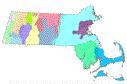
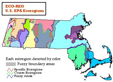
The U.S. Environmental Protection Agency has construed, from geology, hydrology, climate, and the distribution of species, a set of 13 "ecoregions" in Massachusetts. Ecoregions denote areas within which ecosystems (the type, quality, and quantity of environmental resources) are generally similar; they are designed to serve as a spatial framework for environmental resource management. The layer is stored in ArcSDE as two layers named ECOREGIONS_POLY and ECOREGIONS_ARC. MassGIS modified the original EPA-produced layer by replacing its generalized coastline with the MassGIS 1:100,000 coast. The 13 regions (with ID numbers and names) are as follows:
Northeastern Highlands
- 581 - Taconic Mountains: An area of high hills and low mountains that contain the highest point in the state, Mt. Greylock. Streams are high gradient and lakes and ponds are rare. Vegetation is generally northern hardwoods with some spruce-fir at higher elevations.
- 582 - Western New England Marble Valleys/Berkshire Valley/Houstonic and Hoosic Valleys: This area is drained by the Hoosic and Housatonic Rivers. This area harbors farms, evergreen forests, transition and northern hardwood forests, and calcareous fens. The limestone in the area creates alkaline lakes and streams.
- 583 - Berkshire Highlands/Southern Green Mountains: The Deerfield, upper Westfield, Hoosic, and Housatonic Rivers drain this area. Lakes and ponds are relatively abundant. This area has deep soils that support northern hardwoods and spruce-fir forests.
- 584 - Lower Berkshire Hills: Similar to the Berkshire Highlands with its common northern hardwoods, but lacks spruce-fir and harbors transition hardwoods. Lakes and ponds are relatively abundant.
- 585 - Berkshire Transition: Forests are transition hardwoods and northern hardwoods. This area drains to the Westfield and Connecticut River basins.
- 586 - Vermont Piedmont: Forests are transition hardwoods and northern hardwoods. Hills are sometimes quite steep. Surface waters are highly alkaline. This area drains to the Deerfield and Connecticut River basins.
- 587 - Worcester Plateau: This area includes the most hilly areas of the central upland with a few high monadnocks and mountains. Forests are transition hardwoods and some northern hardwoods. Forested wetlands are common. Surface waters are acidic. Many major rivers drain this area.
Northeastern Coastal Zone
- 591 - Connecticut River Valley: The borders of this region are easily defined by the bedrock geology. It has rich soils, a mild climate and low rolling topography. The valley floor is primarily cropland and built land. Central hardwoods and transition hardwood forests cover the ridges.
- 592 - Lower Worcester Plateau: Comprises of open hills and transition hardwood and central hardwood forests. Most parts drain to the Chicopee and Quinebaug Rivers.
- 593 - Southern New England Coastal Plains and Hills: Comprises plains with a few low hills. Forests are mainly central hardwoods with some transition hardwoods and some elm-ash-red maple and red and white pine. Many major rivers drain this area.
- 594 - Boston Basin: Low hills and outlying hilly suburban towns mark this area's rim. The basin itself has low rolling topography and numerous urban reservoirs, lakes, and ponds. The flat areas were once tilled, but are now almost exclusively urban and suburban developments.
- 595 - Bristol Lowland/Narragansett Lowland: This region has flat gently rolling plains. Forests are mostly central hardwoods and some elm-ash-red maple and red and white pine. There are numerous wetlands, some cropland/pasture, and many cranberry bogs. Many rivers drain this area.
- 596 - Cape Cod and Islands: This region was formed by three advances and retreats of the Wisconsin Ice Sheet. The resulting terminal moraines. outwash plains, and coastal deposits characterize the area with their sandy beaches, grassy dunes, bays, marshes, and scrubby oak-pine forests. There are numerous kettle hole ponds, swamps, and bogs. Much of the surface water is highly acidic.
Attributes
The ECOREGIONS_POLY attribute table contains the following items:
| Field name | Description |
|---|---|
| ECOID | Ecoregion ID number (as listed above) |
| ECONAME | Ecoregion descriptive name (item added by MassGIS) |
| FUZZY | Transition areas for which the ecoregion characteristics match both adjacent ecoregions. |
The ECOREGIONS_ARC attribute table contains the following item:
| Field name | Description |
|---|---|
| LINE | Line Type: 0 - State Outline 111 - Specific Ecoregion 222 - Coarse Ecoregion 999 - Transitional "fuzzy" area |
Maintenance
MassGIS is maintaining the datalayer, however no updates are planned.