Downloads
ESRI Shapefile (4.3 MB)
Includes ESRI Shapefile, with ArcGIS 8.3 LYR and ArcView 3.x AVL
Overview
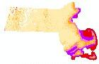
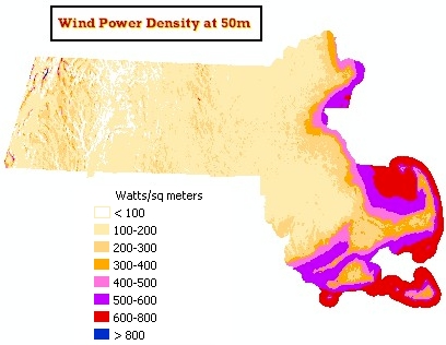
This data layer is a vector version of the AWS Truewind, LLC, Massachusetts Technology Collaborative 50 meter elevation wind power density raster layer. The raster layer work was jointly funded by the Connecticut Clean Energy Fund (now Connecticut Green Bank), the Massachusetts Technological Collaborative, and Northeast Utilities System.
The raster data were re-classified (AWS_CLASS) in accordance with the 8 classes used by Mass. Tech et al. The data were then converted from raster to polygon using the GRIDPOLY command. The PWRDENSITY field was created to show the power density range (watts/sq. meters) for each class. The data were then transformed from WGS1984 to NAD83 SPC using NAD1983toWGS1984 transform 5 (United States) and clipped to the extent of the WINDSPEEDGRID_POLY layer created by MassGIS and AWS Truewind, LLC. Processing of this polygon layer was completed by the Massachusetts Water Resources Authority (MWRA) GIS program and provided to MassGIS for distribution.
The layer is named WINDPOWERGRID50_POLY.
Attributes
The layer's polygon attribute table contains the following items:
| Field name | Description |
|---|---|
| AWS_CLASS | Power density class (as defined by AWS Truewind) |
| PWRDENSITY | Power density range, in Watts per square meters: AWS Class Power density range (watts/sq meters) -1 <100 1 100-200 2 200-300 3 300-400 4 400-500 5 500-600 6 600-800 7 >800 |
Maintenance
This data is not being maintained.