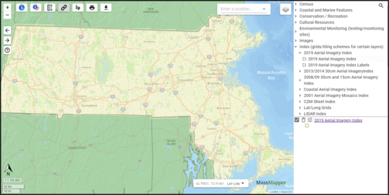
Step 1: Open the MassMapper Interactive Map
All metadata pages that require a MassMapper downloader have a link to a MassMapper, which is loaded with the appropriate tile index. The Download box/link will open MassMapper with the selector index layers showing, similar to below (in this example we are using the 2019 Aerial Images, your index name will be for your data.)
Step 2: Zoom to your area of interest
Use any of these methods to get to your area of interest (AOI).
Most users would start with the "Enter a location" search box by entering an address or city/town. Then fine tune the AOI by using the + - tools or holding the shift key while dragging a box.

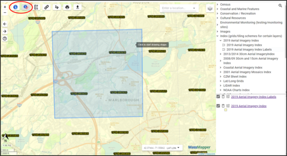
Step 3: Select the files you want to download
Use the single identify tool or the select by drawing a shape tool to select the tiles of interest.
Step 4: Accessing the links
After single clicking one tile or drawing a shape around the tiles of interest and double clicking to close the shape, a popup will appear as seen in the diagram below.

Step 5: Using 3rd party software to automatically download many files
After you have saved the CSV or Excel file, open it and select the cells with the links (e.g., only column D from row 2 to the end, excluding the header row) and copy those to Notepad or another text editing software. Save the list of URLs as a .txt file.
Download the free Persepolis Download Manager or Free Download Manager software and follow their instructions using your saved .txt file as the input file. In Persepolis, we've found the best approach is to add a new queue and choose File > Import links from text file and add them to the new queue and hit the 'Start this queue' button.
Once the zipped files are downloaded, extract the contents of each .zip file and add the data to your GIS software.
| Date published: | November 10, 2021 |
|---|---|
| Last updated: | June 17, 2025 |