A vertical datum is a reference system used by surveyors, engineers, and mapping professionals to measure and relate elevations to the Earth's surface. Using a fixed reference point as a baseline (i.e., a zero elevation point), elevation values can be consistently measured and compared among various maps and surveys. The North American Vertical Datum of 1988 (NAVD 88) is the official vertical datum of the United States, having superseded the older National Geodetic Vertical Datum of 1929 (NGVD 29). Both NAVD 88 and NGVD 29 are geodetic datums, a reference surface of zero elevation to which heights are referred to over a large geographic extent.
A tidal datum is a standard elevation framework used to track local water levels as measured by a tidal gauging station. Some examples of tidal datums include Mean Lower Low Water (the base for National Oceanic and Atmospheric Administration [NOAA] nautical charts and tide charts), Mean Low Water (MLW), Mean Sea Level, Mean High Water (MHW), and Mean Higher High Water (MHHW). (See the NOAA Tidal Datums web page for definitions of these examples.) Tidal datums are often the reference for shoreline or coastal property boundaries where an elevation related to local sea level is needed.
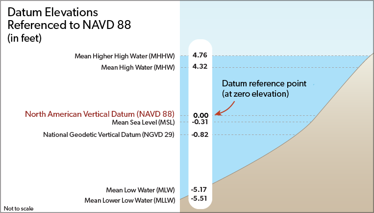
Elevation values from maps using different vertical datums (e.g., NGVD 29, NAVD 88, MLLW, and MHHW) are not directly comparable because they are based on different frameworks and starting (or zero) points. For a depiction of various vertical datums and their elevation differences at the Boston station, see the figure below. For various tidal datum elevations along the entire coast of Massachusetts, see the Buzzards Bay National Estuary Program’s Interactive Tidal Datum Viewer page (where you can zoom in and click on a point to see a table of elevations, such as local mean sea level, NAVD 88, and tidal datums). Tools such as those found on the NOAA National Geodetic Survey and the Office of Coast Survey websites can also be used to convert elevation values between datums. For additional information, see NOAA’s National Geodetic Survey Vertical Datums web page.