Petapawag ACEC Designation Document
Approximate Acreage: 25,630 acres
Watershed(s): Nashua River and Merrimack River
Municipalities (acres; % of ACEC): Ayer (1,960; 8%), Dunstable (6,610; 26%), Groton (14,950; 58%), Pepperell (2,040; 8%), Tyngsborough (70; <1%)
The Petapawag ACEC is located along and to the east of the Nashua River, from the Town of Ayer north to New Hampshire. Petapawag is adjacent to the 37,450-acre Squannassit ACEC, which is located along and to the west of the Nashua River. The Petapawag and Squannassit ACECs share the Nashua River corridor and its associated physical, biological and cultural resources and history. Although the two areas were nominated and designated as separate ACECs, it is important to recognize that the Nashua River corridor is a central resource feature of both of these ACECs.
Sixteen state-listed rare species are known to occur within the boundaries of the Petapawag ACEC. According to the 2001 State BioMap project, approximately 54% of the Petapawag ACEC is BioMap Core Habitat, and approximately 15% of the ACEC is designated as Supporting Natural Landscape. There are 15 State-Certified Vernal Pools within the ACEC, as well as 332 Potential Vernal Pools as identified through photointerpretation by the 2001 Massachusetts Aerial Survey of Potential Vernal Pools. There are also important community drinking water resources present within the ACEC.
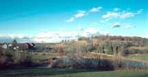
The area contains unique and highly significant archaeological and historical resources, as well as scenic landscapes of statewide significance. There are three state-listed Historic Districts located in Groton. These Historic Districts are part of or are surrounded by scenic landscapes included in the 1982 Massachusetts Scenic Landscape Inventory prepared by the Department of Environmental Management (now the Department of Conservation and Recreation). Several clusters of drumlins, mostly located in a north-south line through the central portion of Groton, are additional unique and distinctive features of the ACEC. Nearly 30% of the ACEC is comprised of protected open space and land under Chapter 61, 61A and 61B tax classification status.
Water bodies included (partially or entirely) in the ACEC
- Lakes, Ponds: Flannagan Pond, pond south of Long Pond, Ayer; Lower Massapoag Pond, pond north of Hound Meadow Hill, Dunstable; Upper Massapoag and Wattles Ponds, pond at Burntmeadow, Groton; Pepperell Pond, Groton/Pepperell
- * Great Ponds: Sandy/Sand Pond, Ayer; Long Pond, Ayer/Groton; Massapoag Pond, Dunstable/Groton/Tyngsborough; Knops Pond/Lost Lake, Whitney/Cow Pond, Martins and Baddacook Ponds, Groton
- Rivers, Streams, Brooks, Creeks: Nashua River, Ayer/Dunstable/Groton/Pepperell; Nissitisset River, Pepperell; James Brook, Ayer/Groton; Black, Camp, Hauk, Horse Hill, Joint Grass and Short Brooks, Dunstable; Baddacook Pond, Blood, Cold Spring, Cow Pond, Martins Pond, NEFF, Nod, Naumox, Oxbow, Swamp and Tuity Brooks, Groton; Reedy Meadow and Unkety Books, Groton/Pepperell; Gardner, Greens, Kemp, Straight and Varnum Books, Pepperell; and several unnamed brooks.
* Boundary Note: The final boundary includes Great Ponds and navigable rivers and streams as determined by the Massachusetts Waterways (or Chapter 91) Regulations (310 CMR 9.00), administered by the state Department of Environmental Protection (DEP). These Great Ponds and waterways will be included within the boundary of the Petapawag ACEC, but the effective date for these areas will be within a period of up to five years following the date of this ACEC designation. Further study and resource management planning for these water bodies is needed before they can be included within the boundary of the ACEC.
Maps
Maps are intended to be used with the written boundary description contained in the ACEC designation document. The mapped boundary is not to be used by itself for definitive ACEC boundary delineation or regulatory interpretation. For review of site-specific projects in or bordering the ACEC, determinations must be made in the field by a certified professional in consultation with the appropriate Conservation Commission(s) and ACEC Program Staff.