Habitat description
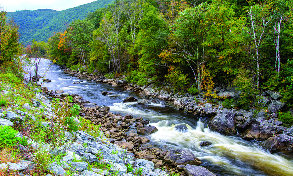
Large, steep, cold rivers characterized by a mix of riffles, pools, and runs (stream order >4, slopes> 2%, summer water temperatures <20°C). These systems are often found in the elevational transition zone between mountain headwater streams and larger valley-bottom mainstem rivers. Substrate in these rivers is composed of bedrock, large boulders, cobbles, and gravels. The large substrate size is a function of high energy systems with fast-moving water, which carries finer sediment downstream to lower gradient reaches. The spaces between the larger substrates are suitable for a variety of environmentally sensitive invertebrate species which in turn support some of Massachusetts’ most charismatic coldwater fish species, including several trout species. Heavily shaded smaller tributaries and groundwater seeps are vital sources of coldwater to maintain habitats for state-listed species like longnose sucker (Catostomus catostomus).
Characteristic communities and species
Because of their location in the watershed and the heterogeneity of mesohabitats, fish communities in large, coldwater rivers often contain coldwater, coolwater and warmwater species within the same reaches. For example, fish communities in the Deerfield River are comprised of eastern brook trout, rainbow trout, and brown trout, all coldwater species; alongside white sucker, longnose dace, creek chub (coolwater species); and brown bullhead, pumpkinseed and chain pickerel (warmwater species). In Massachusetts, coldwater rivers and streams are identified as those where at least one of 11 coldwater fish species are found. Learn more about coldwater fish.
View a complete list of Species of Greatest Conservation Need associated with this habitat.
Associated habitats
Ecological processes
These habitats rely on high-energy storm and flooding events to maintain their ecological form and function. Gravity and discharge combine to keep the substrate moving and provide habitat for many sensitive species. Beaver in these streams build dams, lodges, and food caches that are washed away by high floods in winter and spring. The result is an increase in habitat complexity when nutrients and large wood move downstream.
Threats
- Climate change: Increases in temperatures and changes in precipitation associated with climate change are already shifting ecosystem composition and degrading habitats at different rates. Climate change will continue to threaten biota and human infrastructure in these systems by extending periods of warm dry weather in summer and fall and increasing the magnitude of high flows in winter and spring. Droughts and warm weather will likely shrink or warm existing coldwater habitats making less able to support coldwater species.
- Stormwater: Increasingly high flooding events can dismantle habitat structure by straightening channels and increasing entrenchment. Erosion resulting from heavy rain events can change the composition of stream substrates. These systems are particularly vulnerable to upstream urban development and dams. The lack of appropriate riparian buffers and inputs from reservoirs and wastewater treatment plants can result in warm water inputs that alter the characteristics of these systems. Similarly, water withdrawal can reduce the volume of cold groundwater inputs sustaining habitats.
Conservation actions
- Proactive habitat protection: Protect buffers adjacent to steep cold rivers, control stormwater inputs, and minimize siltation and erosion. Protect mature steep cold rivers and other associated, interconnected habitats to maintain healthy and resilient landscapes for people and biodiversity conservation. Prioritize sites supporting SGCN, as well as other protection priorities identified in BioMap and other conservation planning tools.
- Habitat restoration and management: See recommendations below.
- Law and policy: Regulate and limit the impacts of shoreline development, pollutants, and water withdrawals on these waters. Improve the regulatory protections for coldwater refugia. These streams will need a watershed approach to achieve protection and restoration which will include collaboration among state agencies, partners, and municipalities. Incentivize the protection and maintenance of steep cold rivers on private and public lands. Regulate and limit the impacts of development and consider innovative approaches to incentivizing compatible development, and farm and forest preservation where applicable. Some mature forests make excellent candidates for forest reserves.
Conservation planning: Include steep cold rivers in conservation planning efforts at multiple spatial scales. (See BioMap as an example.)
Surveys, monitoring, and research: Monitor the health and trends of SGCN populations, plant communities, and other wildlife. Monitor the effectiveness of habitat management efforts and conduct targeted research to improve habitat and population management.
Public outreach and education: Educate state residents about the ecological nature of steep cold rivers including climate change impacts. Educate and inform the public about the values of steep cold rivers for biodiversity and water resource conservation through agency publications and other public outreach.
Restoration & management recommendations
The location and scale of relevant management efforts will depend on the attribute being restored. For instance, removal of dams located upstream of other dams are unlikely to open much new habitat to migratory species. However, protection of large tributaries may provide the major source of coldwater to rivers downstream. While smaller projects like these can have significant positive impacts at the local scale, they should be considered within the context of land and water use patterns throughout the watershed.
- Floodplain restoration: Protection and restoration of floodplains throughout the watershed will provide benefits to both the river and proximate infrastructure (e.g., roads). Floodplains that are connected to rivers provide nutrients that support food chains and store waters that are slowly released back to the river channel as flows recede. In some cases, restoration of the floodplain may include setting back impervious surfaces or replacing hard surfaces like riprap, parking lots etc. with soft surfaces like settling ponds or rain gardens.
- Water quality restoration: Because large coldwater rivers are often found at lower elevations, protection of upstream coldwater sources and mitigation of warmwater inputs are imperative to maintaining functioning systems. Protection of upstream coldwater sources may include protection of coldwater tributaries, protection of groundwater aquifers, and instream flows. Mitigation of warmwater inputs may include rerouting of wastewater and road drainage.
- Dam removal: Large coldwater rivers are rare in Massachusetts and yet they are some of the most heavily impacted systems. Large rivers, in general, are often the target of hydropower-generating dams and reservoirs. Dam removal offers the longest-lasting benefit to both the aquatic environment and existing infrastructure. When dam removal is not feasible, passage structures that allow movement for all migratory and resident species
- Water quantity restoration: Management of flows through dams that mimic a natural hydrologic regime will bring the function of dammed large rivers closer to a natural state. Impacts from surface and groundwater withdrawals should be kept at a minimum.
- Channel and shoreline restoration: Channel and shoreline restoration along rivers can take several forms and is closely tied to floodplain restoration. Specific actions include removal of hard structures from streambanks (e.g., riprap, concrete), removal of dikes and berms that constrict channel movement, revegetation of riparian buffers, and contouring of stream banks to lower their elevation. Cold rivers benefit greatly from intact vegetated buffers of widths greater than 200 ft (and up to 3000 ft) to protect water quality (esp. cold temperature) and nutrient cycling.
Examples
Examples of large, high gradient coldwater rivers in Massachusetts include steep mainstem sections of the Deerfield (pictured above) and Westfield (upstream the Town of Huntington) Rivers.
Additional resources
Deerfield River Watershed Association