Habitat description
Rivers with large drainage areas, steep slopes, and average summer water temperatures ranging between 18-22°C (stream order >4, slopes >2%). Generally found in areas with wide floodplains at mid-elevations and upstream of larger warmwater rivers. Substrates in these systems are dominated by boulders, cobbles, and gravel.
Characteristic communities and species
Fish communities include fallfish, common shiner, longnose dace, tesselated darter and creek chub, although not all species may be found at all sites. Popular game fishes also found in coolwater rivers include rock bass and smallmouth bass.
View a complete list of Species of Greatest Conservation Need associated with this habitat.
Associated habitats
Ecological processes
As smaller tributaries come together to form larger rivers, stream channels get deeper and wider. The cooling effect from groundwater and shaded banks weakens, resulting in warmer water temperatures, although colder pockets of water may exist. Large trees falling into the channel continue to be important for the creation of habitat complexity but primary productivity begins to shift away from dependent on riparian vegetation to being supported by within channel components such as algae. At mid-elevations, coolwater river floodplains are set further back from the stream channel than upstream and meanders begin to form. High gradient steams of this scale can experience significant scouring after large storms so changes in channel structure is common.
Threats
- Climate change: Changes in precipitation patterns from climate change are likely to strengthen the impact of peak flows and droughts. Channel scouring will likely become more significant in winter and spring. Water depth is likely to decrease significantly in summer and fall, and some reaches may go dry. Shallower depths combined with warmer summer and fall temperatures may tip coolwater reaches into warmwater habitats at least seasonally.
- Invasive species: Invasive nuisance species have changed the community composition of fishes in some rivers. For example, cutlip minnow, native to more southerly states, is now the most abundant species surveyed in the West Branch Farmington River.
- Dams and urbanization: Dammed reservoirs, road drainage and wastewater can become inputs of warmwater. Dams can become barriers to species migrations, alter streamflow regimes, and disrupt sediment and nutrient cycles. Sand from roads can cement substrates. Land and vegetation alteration in the floodplain and larger watersheds is also a threat.
Conservation actions
- Proactive habitat protection: Protect buffers adjacent to steep cool rivers, control stormwater inputs, and minimize siltation and erosion. Protect mature steep cool rivers and other associated, interconnected habitats to maintain healthy and resilient landscapes for people and biodiversity conservation. Prioritize sites supporting SGCN, as well as other protection priorities identified in BioMap and other conservation planning tools.
- Habitat restoration and management: See recommendations below.
- Law and policy: Regulate and limit the impacts of shoreline development, pollutants, and water withdrawals on these waters. These streams will need a watershed approach in order to achieve protection and restoration involving collaboration among state agencies, partners, and municipalities. Incentivize the protection and maintenance of steep cool rivers on private and public lands. Regulate and limit the impacts of development and consider innovative approaches to incentivizing compatible development.
- Conservation planning: Include steep cool rivers in conservation planning efforts at multiple spatial scales. (See BioMap as an example.)
- Surveys, monitoring, and research: Monitor the health and trends of SGCN populations, plant communities, and other wildlife. Monitor the effectiveness of habitat management efforts and conduct targeted research to improve habitat and population management.
- Public outreach and education: Educate state residents about the ecological nature of steep cool rivers including climate change impacts. Educate and inform the public about the values of steep cool rivers for biodiversity and water resource conservation through agency publications and other public outreach.
Restoration & management recommendations
Improvements to channel function can be made at local scales, for instance through building of instream structures, treatment of wastewater, and limited use of road sand. However, restoration of hydrologic and morphological processes is only relevant within the context of the upstream watershed. Coordinated, comprehensive restoration efforts will benefit from watershed-scale conservation planning.
- Dam removal: Dams affect all large coolwater rivers in the state, both directly when located in river or indirectly when located in tributaries. Dams homogenize both macroinvertebrate and fish communities by altering habitats to favor more tolerant (to increases in temperature and pollutants) and generalist species. For example, reaches once dominated by species like Fallfish and White Sucker shift to favor Largemouth Bass and Bluegill where reservoirs exist. Reaches downstream of the dam become armored (brick-like arrangement of cobbles) because fines like sand and silt are now retained behind dams. Changes to the substrate make it harder for lithophilic species (those needing loose gravel and cobble to spawn and rear) to persist. Reaches downstream of dams in Massachusetts can also be warmer and have lower oxygen concentrations than those upstream. For all these reasons, dam removal is one of the best restoration actions in coolwater rivers which would also increase climate resiliency and protect water quality and quantity. In cases where dam removal is not feasible, passage structures can allow some exchange of species, sediments, and nutrients between upstream and downstream habitats even while not fully restoring river processes.
- Invasive species management:Prevention is the best management strategy for reducing the introduction of invasive species into large coolwater rivers.
- Floodplain restoration: Conditions in large, coolwater rivers benefit from connections to their floodplains. Floodplain restoration actions may includereplacement of paved surfaces with permeable materials, removal of invasive species, and restoring tree and shrub cover. Road surfaces whenever possible should be allowed to infiltrate into the ground rather than divert directly to stream channels.
- Water quantity restoration: Instream flow protection that promotes healthy rivers, particularly under changing climatic conditions, should be at the forefront of water withdrawal management efforts.
- Channel and shoreline restoration: Channel and shoreline restoration along cool rivers can take several forms and is closely tied to floodplain restoration. Specific actions include removal of hard structures from streambanks (e.g., riprap, concrete), “daylighting” of tributaries in urban areas, removal of dikes and berms that constrict channel movement, revegetation of riparian buffers, and contouring of stream banks to lower their elevation.
- Water quality restoration: One of the biggest threats to steep cool rivers is from fine sediments. Large amounts of fine sediment can increase turbidities to a point where fish feeding and movements are restricted. Most fishes are visual feeders so need clear water to find food. Fishes within highly turbid rivers have been found to stop migrations, probably to avoid gill abrasion. Floodplain and watershed restoration that reduce paved surfaces and curtail artificial inputs of water (e.g., storm and wastewater) will promote high water quality.
Examples
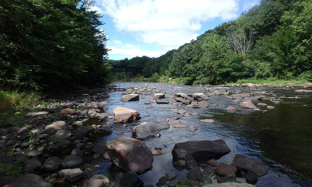
Examples of large high-gradient coolwater rivers in Massachusetts include the Westfield (between Huntington and Russell), Millers (between West Orange and mouth) and West Branch Farmington Rivers (between Roosterville and the Connecticut state border; pictured above).
Additional resources
Westfield River Strategic Plan
Farmington River Watershed Association
Millers River Watershed Council
Wild and Scenic Westfield River Committee
Stop Aquatic Hitchhikers Handout