Between January of 2011 and June 2013, MassGIS completed statewide standardization of assessor parcel mapping for all communities across the Commonwealth. Parcels provided an excellent start on mapping address locations; these locations were needed as part of developing the mapping to support 9-1-1 call routing in the Next Generation 911 System (launched in December of 2017). At the time Boston parcels were not included because of the cost and because the existing Boston data was suitable for the NG911 project’s needs. Since the original standardization, MassGIS funded all municipalities requesting enhancements to the standardized mapping so it met their needs and they could maintain standardization.
The content and links on this page should be used as a resource for maintaining the parcel data to the MassGIS Standard in compliance with requirements from the State 911 Department.
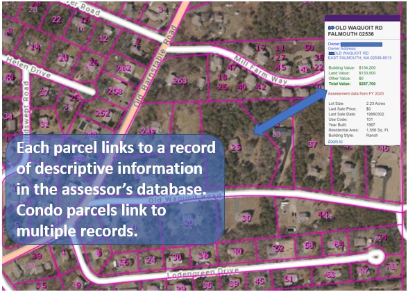
Open Interactive Map to see every parcel in the Commonwealth and selected assessing information.
Open LA3 interactive map to view the prior fiscal year's statewide property sales from the Bureau of Local Services.
More information on Standardized Mapping and its Advantages
What does "standardized parcel mapping" mean?
Standardized parcel mapping refers to creating versions of each community’s assessor mapping that comply with the MassGIS Standard for Digital Parcels and Related Data Sets.
Standardization includes requirements for the
- quality of representing parcel boundaries
- content of a standard extract from the assessing database, and
- the percentage of assessing records that link to a property parcel and vice-versa.
All the companies selling computer assisted mass appraisal (CAMA) software in Massachusetts have developed a “MassGIS Extract” based on the state standard.
What are the advantages of using and maintaining standardized parcel mapping?
- The MAAO endorses the MassGIS Standard as a best practice. (See below)
- In many communities the standardized data provides better quality mapping
- It ensures a very high match rate between maps and assessing data and vice versa; this is important for tasks such as abutter identification.
- It provides seamless integration with parcel data from adjacent communities, whether for supporting emergency response, complete abutter notifications, planning, or development review.
- The MassGIS standard serves as a specification for a map maintenance consultant
- It lowers software application costs because consultants don’t have to customize their application to use your parcel mapping
- It enables tight integration between parcel data and other land records (for example, permit records and registry records)
- It enables state or regional level on-line viewing of parcel data
- It is consistent with the Department of Revenue’s current LA-3 and LA13 reporting requirements and with assessor recertification guidelines.
MAAO
In September 2014, the Executive Board of the MAAO voted unanimously to issue the Statement on Standardized Assessor Tax Mapping (below). The MAAO is dedicated to providing assistance and advice, along with strong educational programs, to aid the local assessor in the performance of their professional duties. The Executive Board of the MAAO feels strongly that standardized tax mapping will help to provide the tools necessary to assist local assessing jurisdictions in providing the taxpayers of their community the type of service that they expect and deserve.
Additional Resources
What are LOC_IDs?
The standardized parcel mapping includes not just mapping but also a subset of information from the assessor’s database. Each parcel on the map is linked to its subset of assessor information. That link is possible because both each parcel and its associated assessing information are “tagged” with the same unique identifier. That identifier is the “locational ID” (referred to as the LOC_ID).
The LOC_ID it is based on the location of a point inside each parcel in the standardized parcel mapping; each LOC_ID is unique statewide.
Why Maintain the LOC_ID in your CAMA database?
The LOC_ID enables tighter and more consistent integration between municipal assessing records and property parcels on the standardized mapping. Trying to link records based on the mapping parcel identifier in assessing records is very inefficient.
This is because the map parcel IDs consist of information about the map, the block, and the parcel lot number (sometimes just map and lot number); these numbers are typically each stored in their own location in the assessing database. When that parcel ID information is exported in a CAMA extract, it must be merged to create a version of that ID that matches what’s found on the assessor parcel map.
For example, an assessor record shows that the property is on map 12, block 2, lot 2A. The map might have that ID as 12-02-2A. For computer mapping software to link the assessing record to the correct parcel, the assessing record must be tagged with a parcel ID in the exact same format as on the map: 12-02-2A.
Further complicating matters, there are multiple ways this is done in every city and town and in every assessing database. The LOC_ID eliminates this problem.
Once they are in the CAMA database, how do I keep LOC_IDs up to date?
LOC_IDs for new or reconfigured lots are created by whoever maintains your parcel maps. So, whenever your maps are updated, your maintenance provider must provide you with LOC_IDs for new or changed parcels (a “LOC_ID change list”). The change list will typically consist of a spreadsheet with map/block/lot information in one column and the corresponding LOC_ID in another column. MassGIS has produced video tutorials showing how to update LOC_IDs using information from a change list.