The worst hurricanes to hit Massachusetts from 1900-2000, in reverse date order, are: Hurricane Bob in 1991; "the twins" from 1954, Hurricanes Carol and Edna; and last but not least, the Great New England Hurricane of 1938.
Hurricane Bob
Developing in the central Bahamas on August 16, 1991, Hurricane Bob intensified and accelerated north-northeastward, paralleling the East Coast, and barreling into Block Island, Rhode Island, and later Massachusetts on August 19. Although this Category 2 hurricane was not among the worst in terms of wind speed or storm surge, the property damage totals alone secured a top-three spot for Hurricane Bob. The Category 3 storms from earlier in the century packed more of a punch, but the extensive coastal development in the second half of the 20th Century left many more homes and other structures in the path of Bob's fury. Overall, New England experienced $680 million in damage, $39 million in Massachusetts alone. Most of southeast Massachusetts faced hurricane-force winds, with coastal communities in these areas seeing sustained winds of 75 to 100 mph. Brewster and North Truro experienced gusts of 125 mph, with North Truro enduring sustained winds of 100 mph. Trees and utility poles were routinely damaged, and 60 percent of the residents of southeastern Massachusetts lost power. The storm surge in Buzzards Bay was 10 to 15 feet, ripping boats from their moorings, destroying homes, and eroding large sections of coastline. Onset, Bourne, Mashpee, and Wareham saw the worst surge, 12 to 15 feet. Mattapoisett was also hit hard, with 29 of 37 homes destroyed on Cove Street and 32 of 35 homes destroyed on Angelica Point. Southern-facing shorelines experienced significant erosion, with some spots along Martha's Vineyard and Nantucket losing up to 50 feet of shoreline.
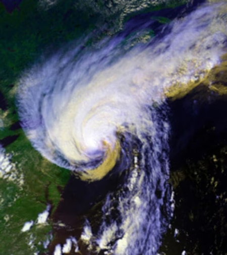
1954 - Hurricanes Carol and Edna
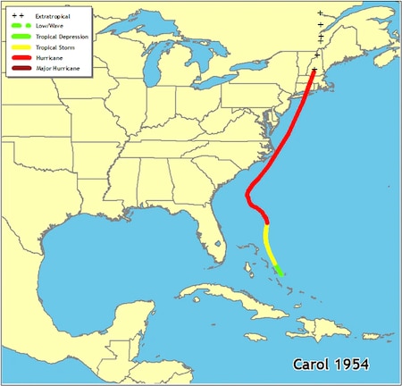
In this year, not one but two Category 3 hurricanes hit New England, Carol and Edna. This double-whammy began at the end of August when Carol formed in the Bahamas. After several days of slow northward progress, Carol accelerated rapidly the evening of August 30, passing just to the east of Cape Hatteras, North Carolina, and continuing toward eastern Long Island and southeastern Connecticut for an August 31 landfall. Most of eastern Massachusetts saw sustained winds of 80 to 100 mph, toppling trees and miles of power lines. Strong winds caused devastation from eastern Connecticut to Cape Cod, ruining 40 percent of apple, corn, peach, and tomato crops. Making landfall just after high tide, Carol's storm surge caused massive flooding, with the Somerset and New Bedford areas receiving the worst of it in Massachusetts. New Bedford's storm surge was over 14 feet. Rainfall of 2 to 5 inches spread across the region, and peaked in north central Massachusetts at 6 inches. Throughout New England, 4,000 homes, 3,500 cars, and 3,000 boats succumbed to Carol, and most of eastern Massachusetts lost phone service and power. And if that wasn't enough . . .
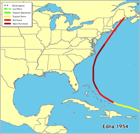
Following a track slightly to the east of Carol, Hurricane Edna barreled up the East Coast, passing over Martha's Vineyard and Nantucket on September 11. All of eastern Massachusetts faced winds of 75-95 mph, with peak gusts on Martha's Vineyard of 120 mph. Portions of eastern Massachusetts and nearly all of Cape Cod and the Islands lost power. The 6-foot storm surge coupled with a rising tide caused severe flooding on Martha's Vineyard, Nantucket, and Cape Cod, and many boats were lost in this region as well. Because Carol had so heavily eroded beaches just days before, these areas were more vulnerable to this second storm. (See The Art and Science of Identifying Flood Zones on page 26 of the 2002 Coastlines [PDF, 4 MB] for more on how cumulative impacts and a lack of recovery time can compound the destructiveness of a storm.) Also, with the storm passing to the east, a heavy rainfall of 3 to 6 inches covered most of Massachusetts, with northeastern parts of the state receiving 7 inches. Still saturated from the rains of Carol, the area experienced extensive urban and stream flooding, with street washouts common, especially in northeast Massachusetts where rivers rose several feet above flood stage. Overall, 21 people died throughout New England as a result of this storm.
Storms are unpredictable, and "100-year" events can happen in rapid succession. (See 100 Year Floods Don't Come on Schedule on page 15 of the 2002 Coastlines [PDF, 4 MB]). Less than a year after Carol and Edna, Connie and Diane brought more destruction to the region. Both storms started as hurricanes, but came ashore in North Carolina, weakened, and moved northward bringing colossal amounts of rain. Together, they dumped almost 25 inches of rain in parts of Massachusetts, causing unprecedented flooding, with 40 percent of downtown Worcester submerged. More than 100 homes were lost in New England, another 1,500 damaged, and 90 people were killed.
Great New England Hurricane of 1938
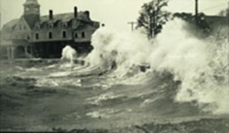
Undoubtedly, the Massachusetts hurricane of the century was the Great New England Hurricane of 1938. Developing off the Cape Verde Islands on September 4, this storm took an unusual track over the Gulf Stream, maintaining its strength over these warm waters until it crashed into Long Island on September 21. The winds were devastating, with the Blue Hill Observatory recording the strongest winds ever for the region, 121 mph sustained winds and gusts of 186 mph. Roofs, trees, and crops were extensively damaged and power outages were widespread, lasting for weeks in some areas. The storm surge was substantial, causing 18 to 25 foot tides from New London east to Cape Cod. Downtown Providence was covered with 20 feet of storm tide and sections of Falmouth and New Bedford were buried under 8 feet of water. Western Massachusetts saw 3 to 6 inches of rain. In Springfield, the Connecticut River rose 6 to 10 feet above flood stage. Overall, 8,900 buildings were destroyed in New England, and another 15,000 were damaged. Coastal communities were decimated; 2,600 boats were destroyed and another 3,300 damaged, and fishing fleets suffered terribly, with 2,605 vessels destroyed and 3,369 damaged. A total of 564 people were killed and another 1,700 injured in southern New England.
Additional Information on Hurricanes
For in-depth information on hurricanes in Massachusetts, see this CZM publication: Coastlines 2002. Links to other information are provided below.
Hurricane Names
Wondering what this year's hurricane names are? Check out this National Hurricane Center page.
Hurricane Categories
The table below gives wind speeds for the different categories of hurricanes.
Saffir/Simpson Hurricane Scale
| Category | Wind Speed |
|---|---|
| One Two Three Four Five | 74-95 mph 96-110 mph 111-130 mph 131-155 mph >155 mph |
For more on the wind scale, see the National Hurricane Center website.
Tracking Chart
Track the course of hurricanes using the Atlantic Basin Hurricane Tracking Chart (PDF, 906 KB) from the National Hurricane Center website.
Photo/image credits for this page: National Oceanic and Atmospheric Administration