Downloads
Tile downloads:
Download from a spreadsheet of links
Download an index shapefile with links
View interactive map download instructions
Overview

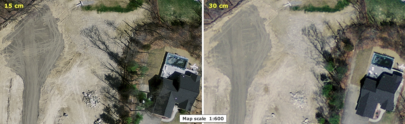
In spring 2008, the U.S. Geological Survey, as part of its Boston 133 Cities Urban Area mapping program, contracted for true-color imagery covering the metropolitan Boston area and beyond. Image type for the entire region (more than 1.7 million acres) is 24-bit, 3-band (red, green, blue) natural color. Each band has pixel values ranging 0-255. Pixel resolution is 30 cm., or approximately one foot.

Additionally, 30 municipalities participated in the Boston Upgrade of the USGS project; these cities and towns contributed funding for separate flights to produce 4-band (red, green, blue, near-infrared) imagery. Pixel resolution for these images is 15 centimeters (approximately 6 inches).
In spring 2009, USGS continued the project and 4-band 30cm imagery was obtained for the remainder of the state. Additionally, 14 municipalities provided funding for 4-band 15cm imagery to cover their communities.
This digital orthoimagery can serve a variety of purposes, from general planning, to field reference for spatial analysis, to a tool for data development and revision of vector maps. It can also serve as a reference layer or basemap for myriad applications inside geographic information system (GIS) software.
MassGIS stores the 2008 portion of the 30cm imagery in ArcSDE as a single raster dataset named IMGCOQ2008_30CM.
Production

Aerial Acquisition
Fugro Earthdata, Inc. acquired the aerial imagery from April 10-18, 2008, flying north-south to support the creation of digital orthophotography with a 15cm pixel (Boston Upgrade areas) and a 30cm pixel (entire Boston UA133 region).
The 15cm imagery was acquired in seven flights, at approximately 4,800 feet above mean terrain (AMT). There were 120 flight lines. The 30cm imagery was acquired in six flights, at approximately 9,440 feet AMT. There were 52 flight lines. All imagery was collected using a Leica ADS40 digital pushbroom sensor. Source imagery was cloud-free. Photography was flown during leaf-off in deciduous vegetation regions. In downtown Boston a "true ortho" method was used to reduce the effects of tall building lean.
The aerial photography used to create the 2009 digital images was acquired by Fugro Earthdata, Inc. between March 24 to April 26, 2009. The orthophotography was created for use by the USGS, The National Geospatial-Intelligence Agency, and MassGIS. There were eleven sorties and 225 flight lines. All imagery was collected using the Leica ADS40-52 digital pushbroom sensor.
Orthorectification
For both years' imagery, Fugro EarthData used ISTAR to process a digital surface model (DSM) for orthorectification of the imagery. ISTAR digital surface modeling is based on an auto correlated pixel-matching system within the ISTAR software. The auto correlated DSM surface represents the initial surface model. The following is the process used:
- Using the DSM, a technician performed a visual inspection of the data to verify that the flight lines met correctly. The technician also verified that there were no voids, and that the data covered the project limits. The technician then selected a series of areas from the dataset and inspected them where adjacent flight lines met.
- This DSM surface is used in the rectification of the orthoimagery.

Ground Control
Dewberry and Davis LLC was contracted by the USGS to acquire photo identifiable ground control points (50 in 2008 and 109 in 2009) during the acquisition of aerial imagery. The ground control points were established using GPS for vertical (NAVD 88 Meters) and horizontal (NAD83(NSRS2007) coordinate values (UTM Zone 19N in 2008, Massachusetts Stateplane Mainland US Survey Meters in 2009).
Spatial Data Quality - Horizontal Positional Accuracy
The 15cm orthophotos were created to be fully compliant with a horizontal positional accuracy not to exceed 0.6 meters Root Mean Squared Error (RMSE). Error XY does not exceed 0.424 meter RMSE in X or Y. The 30cm orthophotos were created to be fully compliant with a horizontal positional accuracy not to exceed 3 meters RMSE. Error XY does not exceed 2.12 meter RMSE in X or Y. Detailed accuracy reports were delivered to MassGIS.
Twenty-one points acquired by the MassHighway Survey Section were used to test the horizontal accuracy of the 15cm imagery. The surveyed coordinates were compared with coordinate values read for the corresponding image in the ortho product. The diagonal RMSE (XY) was 0.21m (NSSDA statistic was 0.36m). This fell within the 0.6m tolerance defined in the Statement of Work.
Forty-nine points also acquired by the MassHighway Survey Section were used to test the horizontal accuracy of the 30cm imagery. The surveyed coordinates for the points were compared with coordinate values read for the corresponding image in the ortho product. The diagonal RMSE (XY) was 0.44m (NSSDA statistic was 0.75m). This fell well within the 3.0m tolerance defined in the Statement of Work.

Processing
Fugro Earthdata, Inc. acquired the aerial imagery from April 10-18, 2008, flying north-south to support the creation of digital orthophotography with a 15cm pixel (Boston Upgrade areas) and a 30cm pixel (entire Boston UA133 region). The 15cm imagery was acquired in seven flights, at approximately 4,800 feet above mean terrain (AMT). There were 120 flight lines. The 30cm imagery was acquired in six flights, at approximately 9,440 feet AMT. There were 52 flight lines. All imagery was collected using a Leica ADS40 digital pushbroom sensor. Source imagery was cloud-free. Photography was flown during leaf-off in deciduous vegetation regions. In downtown Boston a "true ortho" method was used to reduce the effects of tall building lean.
The aerial photography used to create the 2009 digital images was acquired by Fugro Earthdata, Inc. between March 24 to April 26, 2009. The orthophotography was created for use by the USGS, The National Geospatial-Intelligence Agency, and MassGIS. There were eleven sorties and 225 flight lines. All imagery was collected using the Leica ADS40-52 digital pushbroom sensor.
The final digital ortho product delivered to MassGIS was a set of GeoTIFF files in the UTM Zone 19N (in 2008) and NAD83(NSRS2007) Massachusetts Stateplane Mainland meters (in 2009) coordinate systems. Images were non-overlapping tiles covering a 1,500-meter by 1,500-meter block on the ground.
As requested by the Mass. Executive Office of Public Safety, MassGIS "deresolved" the imagery in a few areas for security reasons.
Using ArcGIS Desktop 9.2, MassGIS then merged the 2008 UTM files into large blocks and reprojected the data into the Massachusetts State Plane Mainland NAD83 Meters coordinate system. The projection process resulted in a slight offset of large bands of pixels, most noticeable in linear features (like tennis court lines) when viewed at close scales. Tiles were clipped out into new 1,500-meter by 1,500-meter blocks; each image name is based on the first four digits of the X and Y coordinates of the center of the tile in NAD83 Mass. State Plane meters.
MassGIS' quality assurance included extensive visual examination for errors, anomalies, spatial accuracy and completeness of the imagery. Because the 2009 30cm imagery was delivered in the NAD83(NSRS2007) Massachusetts Stateplane Mainland coordinate system, the mosaic-and-clip methodology used on the 2008 data was not required. However, the NSRS2007 adjustment to the NAD83 coordinate system was not supported by most GIS software, so MassGIS simply "redefined" the spatial reference of each image to the earlier Massachusetts State Plane Mainland NAD83 Meters coordinate system. This final step did not shift the images or result in any loss of horizontal accuracy.
The 2009 15cm imagery was delivered to MassGIS in the Mass. State Plane Feet coordinate system at 6-inch pixel resolution. These image tiles were merged into a single file geodatabase raster dataset, projected to Mass. State Plane Meters at 15cm resolution, and clipped out according to the 2008/2009 ortho index.
Distribution and Download
Because of the large size of the GeoTIFFs, MassGIS is making these images available in the compressed MrSID format (15:1 lossy compression ratio, 3 bands (RGB)). Options include images tiled by the 2008/2009 state plane orthophoto index as well as large regional mosaics. All the 2008/2009 image data distributed by MassGIS are referenced to the Mass. State Plane Mainland NAD83 Meters coordinate system.
The downloads are stored in 1.5km × 1.5km tiles (based on the 2008/2009 Aerial Image Index [PDF] tiling scheme). For the data layers used in the creation of the PDF index map, see the 2008/2009 Aerial Image Index datalayer page.
Displaying the images
Image Catalogs
A file-based image catalog is available for download for use with the MrSID files. Users can load the following image catalog file into some GIS software (including ESRI's ArcMap instead of loading in each individual image; as you pan around and zoom in and and out, the catalog will automatically retrieve and display the image(s) for the current geographic extent. Simply place the image catalog in the same folder on disk with the image files.
- IMGCAT_COQ2008_2009SID_15CM.dbf (15cm MrSID tiles)
- IMGCAT_COQ2008_2009SID_30CM.dbf (30cm MrSID tiles)
Maintenance
The datalayer is maintained by MassGIS. Additional information concerning the technical details of the project may be available upon request.