Downloads
(ESRI Shapefile)
Overview

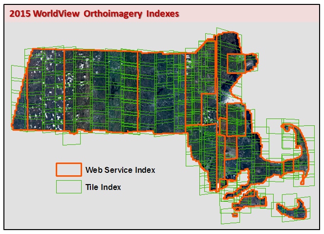
MassGIS has created two polygon data layers to index the 2015 Satellite Imagery:
- The Web Service Index stores information on which imagery was used in the final Web service tile cache, including date of imagery and which satellite (WorldView 2 or WorldView 3) was used to capture the image data. This dataset was created by MassGIS based on strip and tile shapefile provided to MassGIS with the imagery from DigitalGlobe. The statewide Web service is available for use by the general public. This index layer is named COQ2015WVWEBSRVINDEX_POLY. The Web Service Index Map uses this layer.
- Each polygon in the Image Tile Index represents the extent of the individual image files as delivered to MassGIS and contains information such as date of photography, off-nadir angle, sun azimuth and the name of the satellite that captured the data. MassGIS created the index by combining shapefiles provided by DigitalGlobe with the imagery. This index layer is named COQ2015WVTILEINDEX_POLY.
For both layers, the Projection (Spatial Reference) is Geographic (Latitude/Longitude); Datum is WGS 84. Units are decimal degrees. This spatial reference matches that of the imagery.
Attributes
The Web Service Index contains the following fields:
| Field Name | Description |
|---|---|
| PHOTODATE | Date of photography |
| SATELLITE | Name of the satellite (WorldView2 or WorldView3) that captured the imagery |
The Image Tile Index contains the following fields:
| Field Name | Description |
|---|---|
| TILENAME | Code used by DigitalGlobe during production |
| FILENAME | Name of image file as delivered by DigitalGlobe |
| PRODDESC | Code used by DigitalGlobe during production |
| VOLNUM | Code used by DigitalGlobe during production |
| PHOTODATE | Date of photography in YYYYMMDD format |
| SATELLITE | The name of the satellite (WorldView2 or WorldView3) that captured the imagery |
| STRIPDESC | Name of the strip (north-south pass of satellite) of imagery |
| SUNAZIMUTH | Azimuth, in degrees, of the sun at the time the photo was taken |
| OFFNADIR | The angle away from the sensor's nadir (the point directly beneath a scanner's detectors) |
| ACQ_DATE | Photo acquisition date and time |
Maintenance
MassGIS maintains this layer. No updates will be added.