Geography - Census Boundary Areas
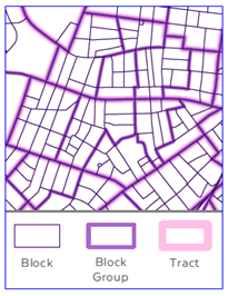
Census geographic areas are used by the Census Bureau to collect, tabulate, and aggregate decennial census data, and are also used in more frequent demographics reports like the annual American Community Survey (ACS). Three levels of areal geography are available from MassGIS (with layer name in parentheses): Blocks, Block Groups, and Tracts. Also see Census Towns data.
Blocks
(CENSUS2020BLOCKS_POLY) Blocks are statistical areas bounded on all sides by visible features, such as streets, roads, streams, and railroad tracks, and by non-visible boundaries such as city, town, township, and county limits, and short line-of-sight extensions of streets and roads. Census blocks cover all territory in the United States, Puerto Rico, and the Island areas. Blocks do not cross the boundaries of any entity for which the Census Bureau tabulates data. Often the size of a city block in urban areas, their size varies in other parts of the state. Census blocks are numbered uniquely within the boundaries of each state, county, and census tract with a 4-character census block number. The first character of the tabulation block number identifies the block group. A block number can only be unique by using the decennial census state (STATEFP<YR>), county (COUNTYFP<YR>), census tract (TRACTCE<YR>), and block (BLOCKCE<YR>) attributes; this concatenated value is recorded in the GEOID20 field. There is no consistency in block numbers from one decennial census to another.
Attributes
| Field | Type | Description |
|---|---|---|
| STATEFP20 | String | 2020 Census state FIPS code |
| COUNTYFP20 | String | 2020 Census county FIPS code |
| TRACTCE20 | String | 2020 Census tract code |
| BLOCKCE20 | String | 2020 Census tabulation block number |
| GEOID20 | String | Census block identifier: a concatenation of 2020 Census state FIPS code, 2020 Census county FIPS code, 2020 Census tract code, and 2020 Census block number |
| NAME20 | String | 2020 Census tabulation block name; a concatenation of ‘Block’ and the tabulation block number |
| MTFCC20 | String | MAF/TIGER Feature Class Code (G5040) |
| ALAND20 | Double | 2020 Census land area in square meters |
| AWATER20 | Double | 2020 Census water area in square meters |
| INTPTLAT20 | String | 2020 Census latitude of the internal point |
| INTPTLON20 | String | 2020 Census longitude of the internal point |
| HOUSING20 | Integer | 2020 Census count of housing units as determined by PL94-171 demographics report for redistricting |
| POP20 | Integer | 2020 Census count of population as determined by PL94-171 demographics report for redistricting |
| AREA_SQFT | Double | Area of the block calculated in square feet |
| AREA_ACRES | Double | Area of the block calculated in acres |
| Shape_Length | Double | Perimeter of the block in meters |
| Shape_Area | Double | Area of the block in square meters |
| TOWN | String | Official name of the city/town the block exists within. Populated via overlay with Census county subdivisions (Towns) and validated via lookup to Census Faces attributes. |
| TOWN_ID | Integer | The town ID assigned to the official town name |
| BLKGRP20 | String | GEOID of the 2020 Census block group that block exists within |
| TRACT20 | String | GEOID of the 2020 Census tract that block exists within |
| COUSUBFP | String | 5-digit FIPS code of the city/town block exists within. Populated via lookup to Census Faces attributes. |
Block Groups
(CENSUS2020BLOCKGROUPS_POLY) - Block groups are clusters of blocks within the same census tract that have the same first digit of their 4-digit census block number; that first digit is the block group number. Block group numbers have a valid range of zero (0) through nine (9). Block groups beginning with a zero generally are in coastal and Great Lakes water and territorial seas. A block group usually covers a contiguous area. Each census tract contains one or more block groups and block groups have unique numbers within a census tract. Within the standard census geographic hierarchy, block groups never cross county or census tract boundaries, but may cross the boundaries of county subdivisions, places, urban areas, voting districts, congressional districts, and AIANNH areas. Block groups delineated for the 2020 Census generally contain 600 to 3,000 people.
Attributes
| Field | Type | Description |
|---|---|---|
| STATEFP20 | String | 2020 Census state FIPS code |
| COUNTYFP20 | String | 2020 Census county FIPS code |
| TRACTCE20 | String | 2020 Census tract code |
| BLKGRPCE20 | String | 2020 Census block group number |
| GEOID20 | String | Census block group identifier: a concatenation of 2020 Census state FIPS code, 2020 Census county FIPS code, 2020 Census tract code, and 2020 Census block group number |
| NAMELSAD20 | String | Translated legal/statistical area description and the 2020 Census block group name |
| MTFCC20 | String | MAF/TIGER Feature Class Code (G5030) |
| ALAND20 | Double | 2020 Census land area in square meters |
| AWATER20 | Double | 2020 Census water area in square meters |
| INTPTLAT20 | String | 2020 Census latitude of the internal point |
| INTPTLON20 | String | 2020 Census longitude of the internal point |
| AREA_SQFT | Double | Area of the block group calculated in square feet |
| AREA_ACRES | Double | Area of the block group calculated in acres |
| Shape_Length | Double | Perimeter of the block group in meters |
| Shape_Area | Double | Area of the block group in square meters |
| TRACT20 | String | 2020 Census tract that block group exists within |
| HOUSING20 | Integer | 2020 Census count of housing units as determined by PL94-171 demographics report for redistricting, aggregated from blocks |
| POP20 | Integer | 2020 Census count of population as determined by PL94-171 demographics report for redistricting, aggregated from blocks |
| BLK20_CNT | Integer | Number of 2020 Census tabulation blocks inside the block group |
Tracts
(CENSUS2020TRACTS_POLY) - Tracts are small, relatively permanent statistical subdivisions of a county or equivalent entity and are reviewed and updated by local participants prior to each decennial census as part of the Census Bureau’s Participant Statistical Areas Program (PSAP). The primary purpose of census tracts is to provide a stable set of geographic units for the presentation of decennial census data. Census tracts generally have a total population size between 1,200 and 8,000 people with an optimum size of 4,000 people. The spatial size of census tracts varies widely depending on the density of settlement. Ideally, census tract boundaries remain stable over time to facilitate statistical comparisons from census to census. However, physical changes in street patterns caused by highway construction, new development, and so forth, may require boundary revisions. In addition, significant changes in population may result in splitting or combining census tracts. Tracts do not cross state and county boundaries in the standard census geographic hierarchy, but tracts can cross the same kinds of boundaries that block groups can. Census tract numbers have up to a 4-character basic number and may have an optional 2-character suffix. The census tract numbers (used as names) eliminate any leading zeroes and append a suffix only if required. The 6-digit census tract codes, however, include leading zeroes and have an implied decimal point for the suffix. Census tract codes (000100 to 998999) are unique within a county or equivalent area.
Attributes
| Field | Type | Description |
|---|---|---|
| STATEFP20 | String | 2020 Census state FIPS code |
| COUNTYFP20 | String | 2020 Census county FIPS code |
| TRACTCE20 | String | 2020 Census tract code |
| GEOID20 | String | 2020 Census tract identifier; a concatenation of 2020 state FIPS code, county FIPS code, and census tract code |
| NAME20 | String | 2020 census tract name, this is the census tract code converted to an integer or integer with 2- decimals if the last two characters of the code are not both zeros. |
| NAMELSAD20 | String | Translated legal/statistical area description and the 2020 Census tract name |
| MTFCC20 | String | MAF/TIGER Feature Class Code (G5020) |
| ALAND20 | Double | 2020 Census land area in square meters |
| AWATER20 | Double | 2020 Census water area in square meters |
| INTPTLAT20 | String | 2020 Census latitude of the internal point |
| INTPTLON20 | String | 2020 Census longitude of the internal point |
| AREA_SQFT | Double | Area of the tract calculated in square feet |
| AREA_ACRES | Double | Area of the tract calculated in acres |
| Shape_Length | Double | Perimeter of the tract in meters |
| Shape_Area | Double | Area of the tract in square meters |
| HOUSING20 | Integer | 2020 Census count of housing units as determined by PL94-171 demographics report for redistricting, aggregated from blocks |
| POP20 | Integer | 2020 Census count of population as determined by PL94-171 demographics report for redistricting, aggregated from blocks |
| BLK20_CNT | Integer | Number of 2020 Census tabulation blocks inside the tract |
Processing
MassGIS downloaded Census 2020 geographic data from the Census Bureau’s website using the following links:
(Get a full set of TIGER/Line shapefiles and relationship files available for download from the Census Bureau). Each of these statewide shapefiles was extracted from the zip files and projected into the standard MassGIS data library spatial reference (Massachusetts State Plane NAD 1983 Mainland, Meters).
The downloaded Census geography files for Massachusetts included areas that extend into coastal waters. MassGIS incorporated a generalized coastline into the three layers (and the Census Towns layer) by removing areas flagged as water along the coast (using the LWFLAG attribute in the Census Faces data), interactively reviewing and editing select locations that remained visually incongruous with the 2021 aerial imagery, and re-adding a small number of modified areas identified as being entirely water but containing a non-zero population (indicative of “transient units” like house boats).


MassGIS reviewed attributes for function and utility; nearly all native attributes were retained. UR20, UACE20, and UATYPE20 were deleted from the Census 2020 tabulation blocks because 2020 Urban Areas had not yet been defined and they had no values in any record. FUNCSTAT was deleted from the blocks, block groups, and tracts because every geographic feature had the same value of “S” assigned. Additional attributes were added to each geography file as appropriate to facilitate anticipated user needs.
Use limitations
As stated in section 1.1 of the technical documentation… “No warranty, expressed or implied, is made with regard to the accuracy of the data in the TIGER/Line Shapefiles, and no liability is assumed by the United States Government in general, or the Census Bureau specifically, as to the positional or attribute accuracy of the data. The boundary information in the TIGER/Line Shapefiles is for statistical data collection and tabulation purposes only. Their depiction and designation for statistical purposes does not constitute a determination of jurisdictional authority or rights of ownership or entitlement and are not legal land descriptions. TIGER/Line® is a registered trademark of the Census Bureau. TIGER/Line cannot be used as or within the proprietary product names of any commercial product including or otherwise relevant to Census Bureau data and may only be used to refer to the nature of such a product.”
If there are any questions about these geographic layers not answered by the Census Bureau 2020 TIGER/Line shapefiles documentation, please direct them to daniel.marrier@mass.gov.