Downloads
Overview

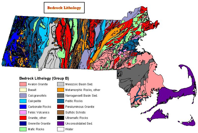
Lithology is the science of the mineral composition and classification of rocks, and their mode of occurrence in nature. This polygon data layer shows the dominant lithology and geochemical, termed lithogeochemical, character of near-surface bedrock in Massachusetts. The bedrock units in the map are generalized into groups based on their lithological composition and, for granites, geochemistry.
Obtained from the U.S. Geological Survey (USGS), the data set provides digital geologic information that may be applied to the analysis of water-quality characteristics of surface water and shallow ground water, and soil and stream sediment characteristics based on bedrock lithogeochemistry. The geologic characterization provided in this classification is intended to portray significant bedrock geologic features that influence stream sediment and soil chemistry and water quality. The source geologic map scales range from 1:100,000 to 1:500,000. The spatial accuracy of the layer is estimated as 1.5 km. For more details, please see the complete FGDC-style metadata produced by the USGS.
The layer is stored in ArcSDE and distributed as BEDROCKLITHOLOGY_POLY.
Production
The Department of Environmental Protection GIS Group obtained the digital data files from the USGS and projected the layer into the Massachusetts State Plane NAD83 Meters Mainland coordinate system. The layer, which originally included data for all of New England, was then clipped using MassGIS' 1:100,000 State Outline layer.
Attributes
The polygon attribute table contains the following items:
| Item | Type/Width | Description |
|---|---|---|
| STATE | C / 8 | Most "MA" for Massachusetts. Some slivers remain along state boundary due to slight discrepancies between the MassGIS 100k OUTLINE coverage and the boundary used by USGS. |
| HYDRO_BSN | C /25 | Drainage basin |
| G_PROVINCE | C /25 | Geologic provinces. The map units in each province group share common features of lithology, age of formation, geologic setting, and tectonic history. |
| G_PROV_ID | C /15 | A one- or two-letter abbreviation for the geologic provinces |
| ROCK_GPA | C /24 | A broad categorization of lithogeochemical units. Each category under these headings shares similarities in overall geochemistry and lithology. |
| ROCK_GPB | C /24 | Further subdivision of the broad categories of lithgeochemical units defined by ROCK_GPA |
| R_GPB_ID | C /12 | Numerical code for ROCK_GPB values |
| LITHO_CODE | N /18 | Lithogeochemical classification code, developed for this data set |
| LITH_MOD | C /10 | Lithogeochemical classification code, developed for this data set that further subdivides the lithogeochemial groups based on the presence of carbonate and(or) sulfide mineral or on the relative age of the bedrock unit. |
| BEDROCK_1 | C /30 | Bedrock Unit label appearing on the state geologic map used as the source for the lithogeochemical categorization |
| BEDROCK_2 | C /30 | Bedrock unit codes characterized by state and including value for water bodies. Except for surface waters, this field is the same as BEDROCK_1. |
Maintenance
MassGIS is managing this datalayer. No updates are anticipated.