Downloads
Overview
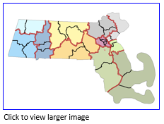
At the highest level DCR properties are organized into two management 'Divisions': Mass Parks and the Division of Water Supply Protection (DWSP). Mass Parks properties are organized into Regions. Each region is divided into Districts, which in turn are divided into Complexes. This layer delineates these breakdowns.
The two feature classes - polygon and arc - are stored in ArcSDE as REGDCR_POLY and REGDCR_ARC.
Production
This layer was created by DCR and then was processed and stored by MassGIS.
Attributes
The polygon attribute table contains the following fields:
| Field | Description |
|---|---|
| REGION | Within the DCR Mass Parks division, this is the broadest level of management. Each Mass Parks 'Region' is broken up into 'Districts,' then 'Complexes'. |
| DISTRICT | The second level of management down from 'Region': each Mass Parks District belongs to a 'Region' and is divided into 'Complexes'. Complexes are included in the arc attribute table. |
| DIVISION | All are coded "Mass Parks" |
| SYMBOLOGY | A single field for symbology or labeling that concatenates the REGION and DISTRICT values |
The arc attribute table contains the following items:
| Field | Description |
|---|---|
| TYPE | Boundary type: Complex District Golf Course Complex MA Coast State Border |
Maintenance
DCR will provide any updates to MassGIS.